Maps

Term Path Alias

/sub-categories/maps

Visualizing the Vrishabhavathi river to keep it alive
In an effort to inform the general public, especially citizen activists, policymakers, researchers, and students, about the current status of the Vrishabhavathi river, Paani.Earth has created the necessary maps, data, analysis, and information to drive conservation awareness and action around the river. Posted on 06 Oct, 2022 05:55 PM

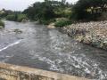
A river or a cesspool of waste?

Vrishabhavathi river (Image Source: Paani.Earth)
Rivers of Bengaluru: A map-infographic reflects the rivers’ state
In an attempt to present a perspective on how rivers are used and abused, a map of the Bengaluru rivers illustrate how waste flows through natural river corridors, polluting the rivers and altering their status. Posted on 05 Sep, 2022 12:56 PM

Bengaluru rivers illustrated in a simple yet spatial way

Vrishabhavathi river flow at Thagachguppe Bridge, Kumbalgodu (Image Source: Paani.Earth)
Let’s buck up and deal with deluge
Massive floods have made a comeback this year. What can we do to be better prepared for this new normal? Posted on 12 Sep, 2017 06:00 AM

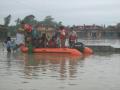
It was supposed to be a normal monsoon as Indian Meteorological Department had predicted. But barring the central plateau, the rest of India may be forgiven for thinking that the Biblical deluge has come a second time.

Members of the national disaster response force evacuate residents of a flooded village in Bihar. (Source: NDRF)
Farakka faces a barrage of criticism
The Farakka barrage is an ageing symbol of our need to control rivers and our inability to do so. Can we do away with it? Posted on 27 Aug, 2016 08:25 AM

The chief minister of Bihar, Nitish Kumar, called for the decommissioning of the Farakka barrage recently.

The lower Ganga, just upstream of Farakka, displays bank-cutting and erosion.
Rejuvenating traditional water system in Maharashtra
Caught between Malguzaars and the state government, the Malguzari tanks were left to die many years ago. A lone man spearheaded their revival in 2008. Posted on 02 Aug, 2016 09:44 AM

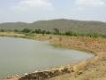
Malguzari tanks were ponds made for water harvesting by the Malguzaars, who were zamindars or tenants in eastern Vidarbha, Maharashtra two centuries ago.These tanks provided water for irrigation and also increased the availability of fish for local consumption.

Janbhora Malguzari tank in Bhandara
The challenged coasts of India: A report
The report highlights how degradation of the coastal environment has reached alarming proportions, closely reflecting the urban population explosion and rapid and unplanned urbanisation. Posted on 05 Dec, 2014 10:18 AM

Aims of the report:

Fishing, an important coastal activity
NadiSutra: A 2000 km canoe ride to tell a river's story
A father-son team will follow the river Mahakali, which is proposed to be the longest and most radical link, to see and experience the effects of interlinking on the entire river system, and beyond. Posted on 01 Dec, 2014 01:19 PM

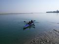
2000 km on a kayak to follow 'their' river, to see and experience firsthand the progressions from the glaciers to the ocean, and to bear witness, both through images and the written word, to the radical changes being wrought on the entire river system, and beyond.

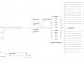
A long, winding and confusing path

Theo and Zanskar set off on their canoe
Urban water supply maps
Our experiences of building a visual map of water supply to Chennai from available data sets on water quality and water related infrastructure by NEERI are noted in this article. Posted on 07 Apr, 2014 06:43 AM

Cleaning, analysis and contextualizing the available data

Chennai water supply map (summer)
Mapping Bangalore's water supply
The experience of building a visual water supply map of Bangalore city from available data sets by NEERI is noted in this article. Posted on 07 Apr, 2014 06:14 AM

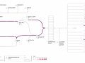
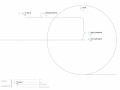
The construction of a visual map of water supply to Bangalore city from available data sets on water quality and water related infrastructure by NEERI as a part of the data project started by India Water Portal, Arghyam was a challenging task.

The visualisation process

Bangalore water supply base map
Mapping Mumbai's water supply
Our experience in building a visual water supply map of mumbai city from available data sets by NEERI is noted in this articles. Posted on 07 Apr, 2014 06:09 AM

The construction of a visual map of water supply to Mumbai city from available data sets on water quality and water related infrastructure by NEERI as a part of the data project started by India Water Portal, Arghyam was a challenging task.

The visualisation process

Mumbai water supply base map
×