Term Path Alias
/sub-categories/maps
/sub-categories/maps
Author: K.M.Seenivasan
This publication by the Central Water Commission (CWC) and Regional Remote Sensing Centre – West, Indian Space Research Organisation (ISRO) presents the status of water resources development in each of the river basins as per CWC classification. It was launched on November 1, 2012 by Minister of Water Resources Shri. Harish Rawat in a function organized at CWC, New Delhi.
This comprehensive publication gives detailed information of major water resources projects along with the location of all hydrological observation sites including major dams, barrages etc. in all the river basins of India.
This "River basin atlas of India", an outcome of joint project “Generation of Database and implementation of web enabled Water Resources Information System (India-WRIS) in the country”, is a publication by the Central Water Commission (CWC) and Regional Remote Sensing Centre – West, Indian Space Research Organisation (ISRO) that presents the status of water resources development in each of the river basins as per CWC classification. It was launched on November 1, 2012 by Minister of Water Resources Shri. Harish Rawat in a function organized at CWC, New Delhi.
This comprehensive publication gives detailed information of major water resources projects along with the location of all hydrological observation sites including major dams, barrages etc. in all the river basins of India. All these features have been portrayed on the maps with river network, major cities and terrain in background. The hydrological and Flood Forecasting observation sites of Central Water Commissions are also marked in the basin maps.
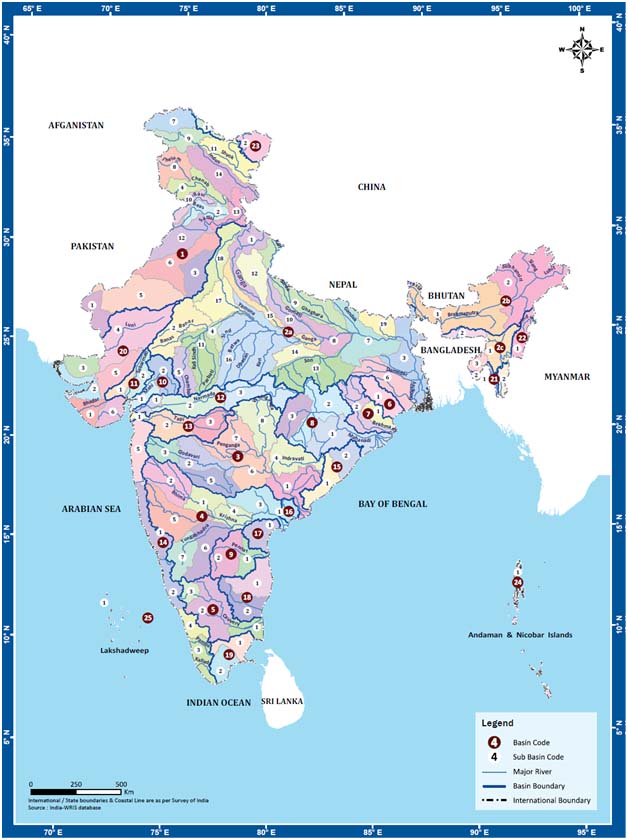
India-WRIS Sub-basins, Source: River basin atlas of India, CWC and ISRO, 2012
This report presents information about the status of landslides in Sikkim. It was commissioned by the Department of Science and Technology and authored by the Wadia Institute of Geology. It draws upon several archives including that of the Directorate of Geology and Mining, Government of Sikkim. The report also presents recommendations for preparing an action plan for undertaking landslide studies.
It is therefore crucial that we look after this resource and ensure that it is managed properly.Over reliance on groundwater for both domestic and commercial purposes has led to over-exploitation and contamination of groundwater. In order to make groundwater sustainable, there is a need to understand the aquifer characteristics as well as its overall geological setting.
The Environmental Information System Centre, Department of Environment has prepared groundwater quality maps of Tamil Nadu. Water is considered to be hard when it contains high level of dissolved minerals. This may be of natural occurrence or due to human activities such as industrialisation leading to water pollution.
This atlas on water resources in Andhra Pradesh by International Water Management Institute (IWMI), IWMI-Tata Water Policy Program (ITP), Visual Information Systems for Action (VIStA) and
Past studies have found associations between land and poverty, however these studies are usually focused on small areas using ground based studies.
Dear India Water Portal readers,
Article Courtesy : Resources Centre for Sustainable Development
The interactive GIS mapping of wetlands and MUS intervention sites is one of the outputs of the project.
Interactive layers are present on the left panel of the pdf file.
The Geological Survey of India (GSI) has been preparing state geology and mineral maps as a part of its Miscellaneous Publications series from time to time. During the span of three and a half decades since the first edition was published, enormous knowledge has been added in the sphere of geology of the areas necessitating revisions. The entire modified and updated series published at various points of time is available here.