/sub-categories/maps
Maps
Impact assessment of urbanization in Indian city of Ranchi – A report in Geospatial World
Posted on 02 Apr, 2011 07:49 AMPatterns of spatial and temporal urban changes have been analysed efficiently using spatial and temporal technologies such as Geographical Information Systems (GIS) and Remote Sensing (RS) along with collateral data such as Survey of India (SOI) maps, etc.
Understand water conflicts around India with the help of Google Maps - Water Conflicts Forum
Posted on 14 Feb, 2011 12:42 PMWe are beginning this effort with the conflicts that we have already documented by the Forum. You could also contribute to this effort by sending in abstracts of conflict cases that you know.
Watershed prioritisation atlas for Maharashtra
Posted on 09 Feb, 2011 07:34 AMThis document by the Maharashtra Remote Sensing Applications Centre (MRSAC) presents the “Atlas on Watershed Prioritisation” using resources database on 1:2,50,000 scale adopting a
Conference on values and practices that promote food sovereignty in the context of climate change, Pipal Tree, 16 - 19 February 2011, Bangalore
Posted on 21 Jan, 2011 05:22 PM Organizer: Pipal Tree
Venue: Fireflies Inter-religious Ashram, Bangalore, India
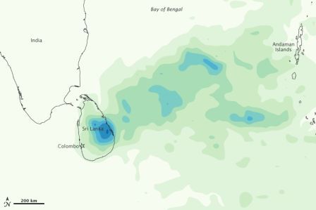
Heavy Rains in Sri Lanka - Update from Earth Observatory
Posted on 20 Jan, 2011 01:48 PMSri Lanka’s government stated that the death toll from flooding had risen to 13, and officials were arranging food drops to hardest-hit areas in the east.

![]()
India s groundwater challenges and the way forward
Posted on 18 Jan, 2011 11:42 PMIndia’s Groundwater Challenge and the Way Forward
P S Vijay Shankar , Himanshu Kulkarni , Sunderrajan Krishnan
The groundwater crisis is acquiring alarming proportions in many parts of the country. Strategies to respond to groundwater overuse and deteriorating water quality must be based on a new approach involving typologising the resource problems and redefining the institutional structure governing groundwater. This approach is based on the notion of groundwater as common property.
Damming North East India - Juggernaut of hydropower projects threatens social and environmental security of region
Posted on 28 Dec, 2010 07:49 PM This report by Kalpavriksh, Aaranyak and ActionAid India deals with the large dams’ juggernaut, which happens to be the biggest ‘development’ intervention in this ecologically and geologically fragile, seismically active and culturally sensitive region in the coming days. With the Northeast identified as India’s ‘future powerhouse’ and at least 168 large hydroelectric projects set to majorly alter the riverscape, large dams are emerging as a major issue of conflict in the region.
Although the current scale of dam-related developments far outstrips anything which took place in the past, the region has been no stranger to dam-related conflicts. For example, the Kaptai dam, built in the Chittagong Hill Tracts of East Pakistan (now Bangladesh) in the 1960s, submerged the traditional homelands of the Hajong and Chakma indigenous communities, and forced them to migrate into parts of Northeast India.
High altitude wetland protected areas in western Arunachal Pradesh - Identification and demarcation using GIS
Posted on 27 Dec, 2010 11:15 PMGuest Post by Shashank Srinivasan
High altitude wetlands in the Indian Himalayas are crucial to the water security of downstream communities. They buffer the flow of glacial meltwater to sustain river flow in the dry season, ensuring that human settlements have access to water when they need it most.
High altitude wetlands are also reservoirs of biodiversity and contribute local livelihood opportunities. Identifying these wetlands and demarcating areas for their protection is thus crucial to any wetland management plan.
In this poster, a method of using topographic data obtained by remote sensing techniques, to identify the catchment areas of these wetlands has been described.
The author suggests that the protection of these catchment areas will ensure the survival of these wetlands, as well as of the communities that depend on them.
Geospatial World Forum 201, GIS Development, Hyderabad
Posted on 07 Dec, 2010 11:40 AMGeospatial World Forum 2011
Theme: Dimensions and Directions of Geospatial Industry
Ecological Sanitation locations in India
Posted on 01 Dec, 2010 04:55 PMEcological Sanitation is a new approaching sanitation where there is minimal water use and where human waste can be used as fertilizer. It is a truly sustainable approach.