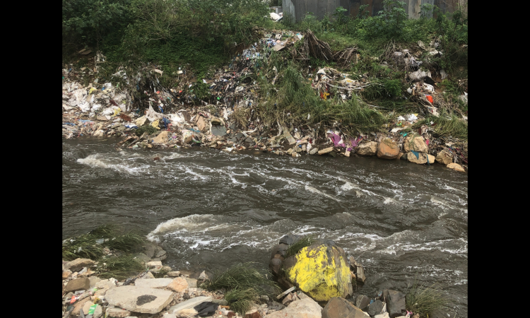
A river or a cesspool of waste?
The 69-Km long Vrishabhavathi is the urban-industrial river of Bengaluru- India’s silicon valley. Heavily modified and egregiously polluted, Vrishabhavathi does not exist in her natural form. Not even close. She is an open sewer for a toxic mix of human waste, industrial effluents, and solid waste. Because of this, she is often called Visha-bhavathi (Visha meaning poison in the Kannada Language).
Understanding the river through its map
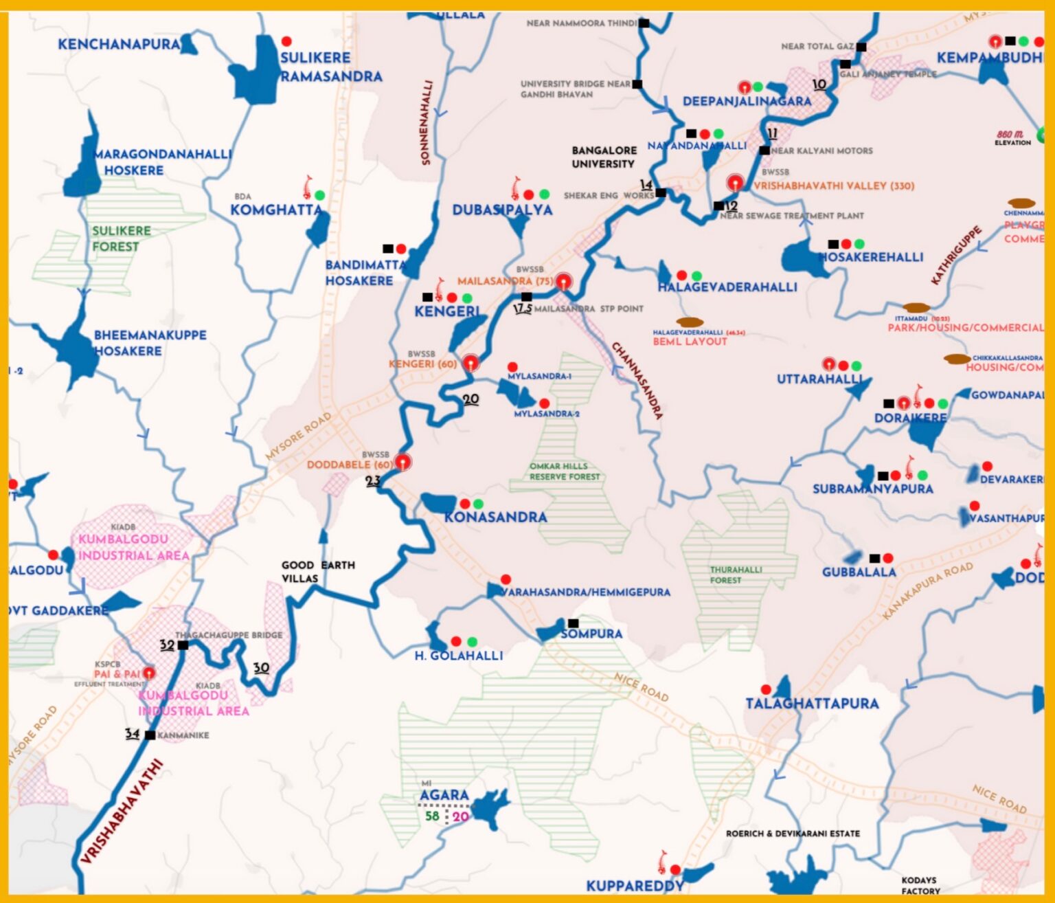
Vrishabhavathi river is most talked-about among the citizens, media, academia, private researchers, and various government bodies for its alarming levels of toxic pollution. There are many public interest litigations in high court to get the river cleaned up. Despite this, a basic river basin map does not exist. However, Paani.Earth has produced the Vrishabhavathi river map to fill this gap. It is an interactive map, where you can click on lake names to reach the Google Earth location of the lake.
The Vrishabhavathi river map is a colorful and slightly complex map, that plots a wide range of human activities affecting the river: industrial clusters, sewage treatment plants, industrial effluent treatment plants, hazardous waste landfills, urban centers, open-pit quarries, hydropower plants, etc. It also provides details of lakes in the basin along with drainage and flow direction. Also, check out the list of of 25 useful data points given on the map.
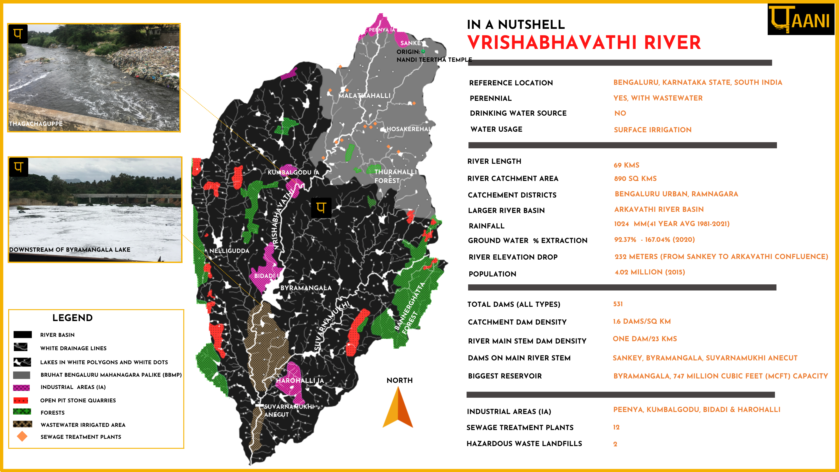
Vrishabhavathi river - In a nutshell
Here is a handy snapshot of the comprehensive Vrishabhavathi river basin map. The nutshell spatially represents drainage, lakes, tributaries, industrial areas, quarries, sewage treatment plants and protected areas along with a tabular representation of river basin data.
Origin of the river and its confluence
Vrishabhavathi river origin has not been easy to find. And what we have found cannot be conclusively said to be the river origin. The Bangalore district gazetteer documents the birthplace as Basavanagudi. A report by the Indian Institute of Science (2017), first says the river originates at Bull temple, a small hillock next to Dodda Ganapathi Temple in Basavanagudi. Then it goes on to say that the river originates near Sankey tank, Sadashivanagara. Then again, for the third time, the Indian Institute of Science report says the river originates at Nandi temple in Basavanagudi, creating immense confusion.
According to the, the Central Pollution Control Board report (2019), the river originates in the suburbs of Yeshwanthpura, Peenya while an article by The New Indian Express suggests Nandi Teertha temple opposite Kadu Malleshwara temple in Malleswaram may be the origin. However, there is no proof, as the article itself admits.
The natural topography of the Malleswaram area, analyzed using geospatial tools and field investigations, showed that the stream overflowing from the Sankey Tank flows around the temple area. We couldn’t find the headwater streams, as they are all covered, concretized, and converted into wastewater drains. Just a few meters from the temple, we spotted the concretized open river channel carrying wastewater. (It had just rained and thus clear waters in the image below).
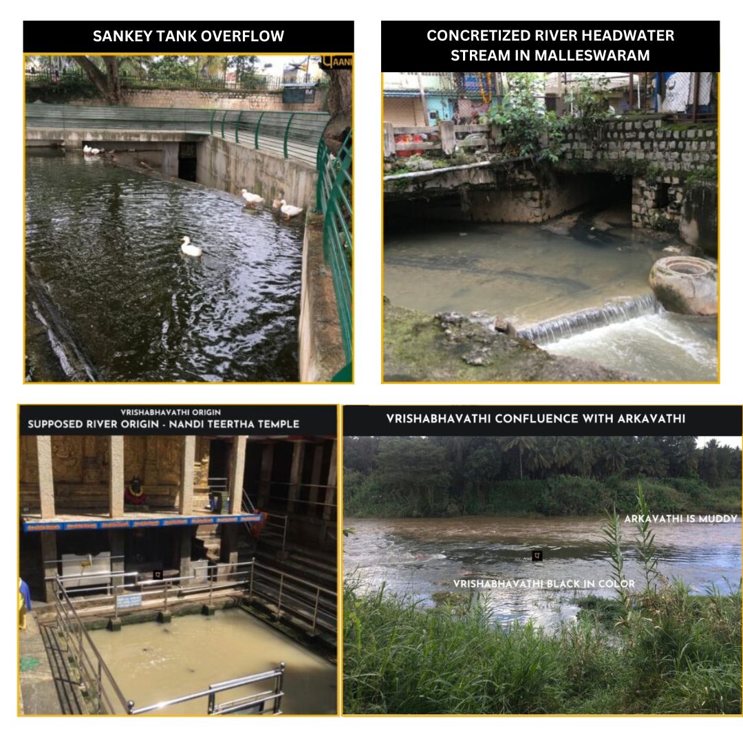
Based on these observations in Malleswaram area, we have marked the Nandi Teertha temple as the supposed river origin. The altitude at the origin is 906 m. Vrishabhavathi river elevation drops by 278 meters as she flows from origin to her confluence point with Arkavathi.
The main tributary of the Arkavathi, the Vrishabhavathi river runs through the south-western parts of Bengaluru and Ramanagara district for about 69 kms (as measured from Sankey tank) before joining Arkavathi near Ganalu village close to Kanakapura town. The image above shows the black waters of Vrishabhavathi merging with the muddy waters of Arkavathi.
Administrative boundaries of the river
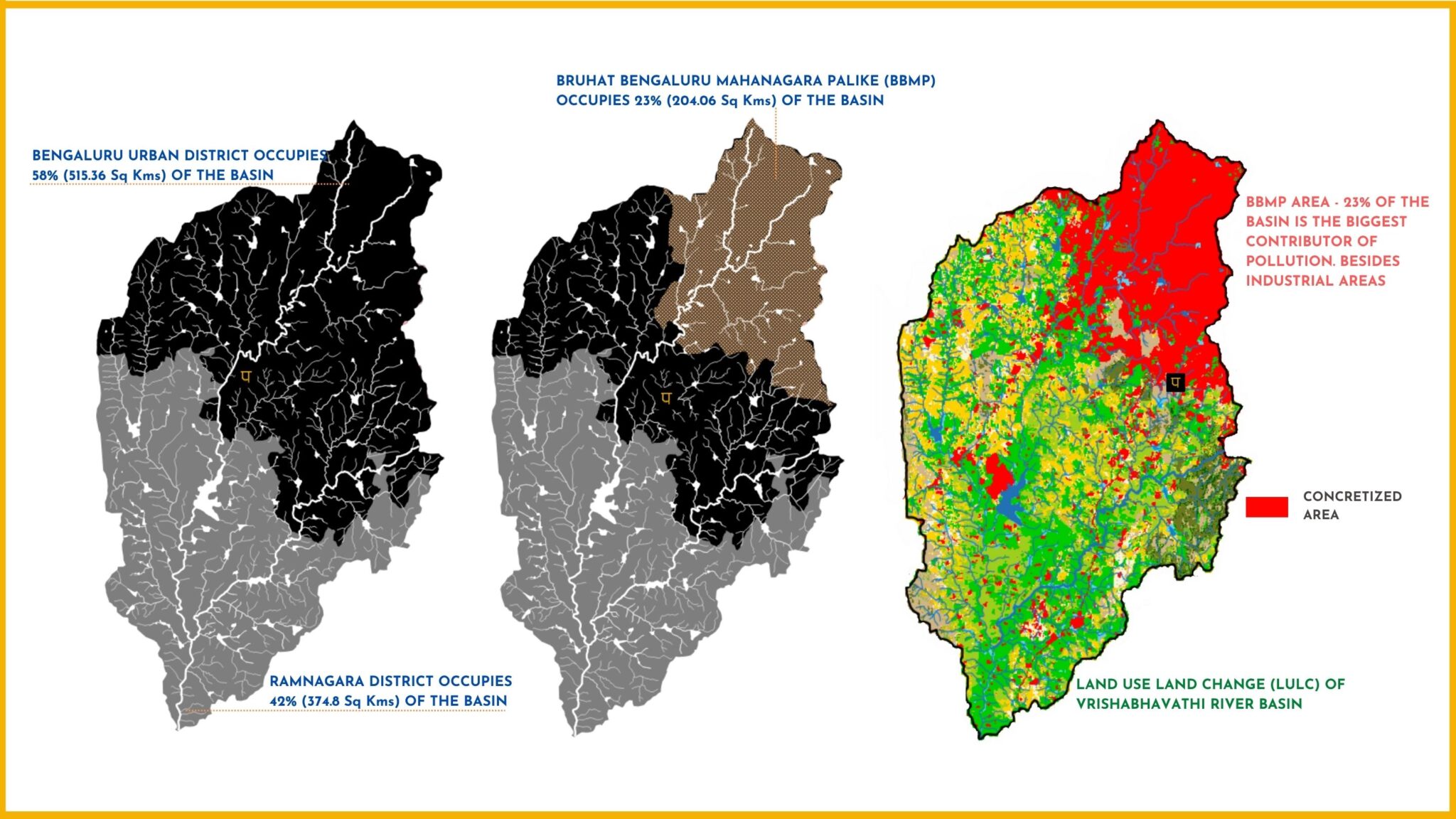
- Vrishabhavathi river basin is spread over two districts – Bengaluru Urban (forms 58% of the basin) and Ramnagara (forms 42% of the basin) as shown in the image below.
- Bruhat Bengaluru Mahanagara Palike (BBMP)- Bengaluru Urban district’s city municipality, occupies 23 percent of the catchment.
The 2015 Bhuvan’s land use land cover shows complete concretisation of the BBMP area. This 23 precent concretized stretch of the river is the single biggest contributor of sewage and solid waste in the river.
Rainfall in Vrishabhavathi river basin
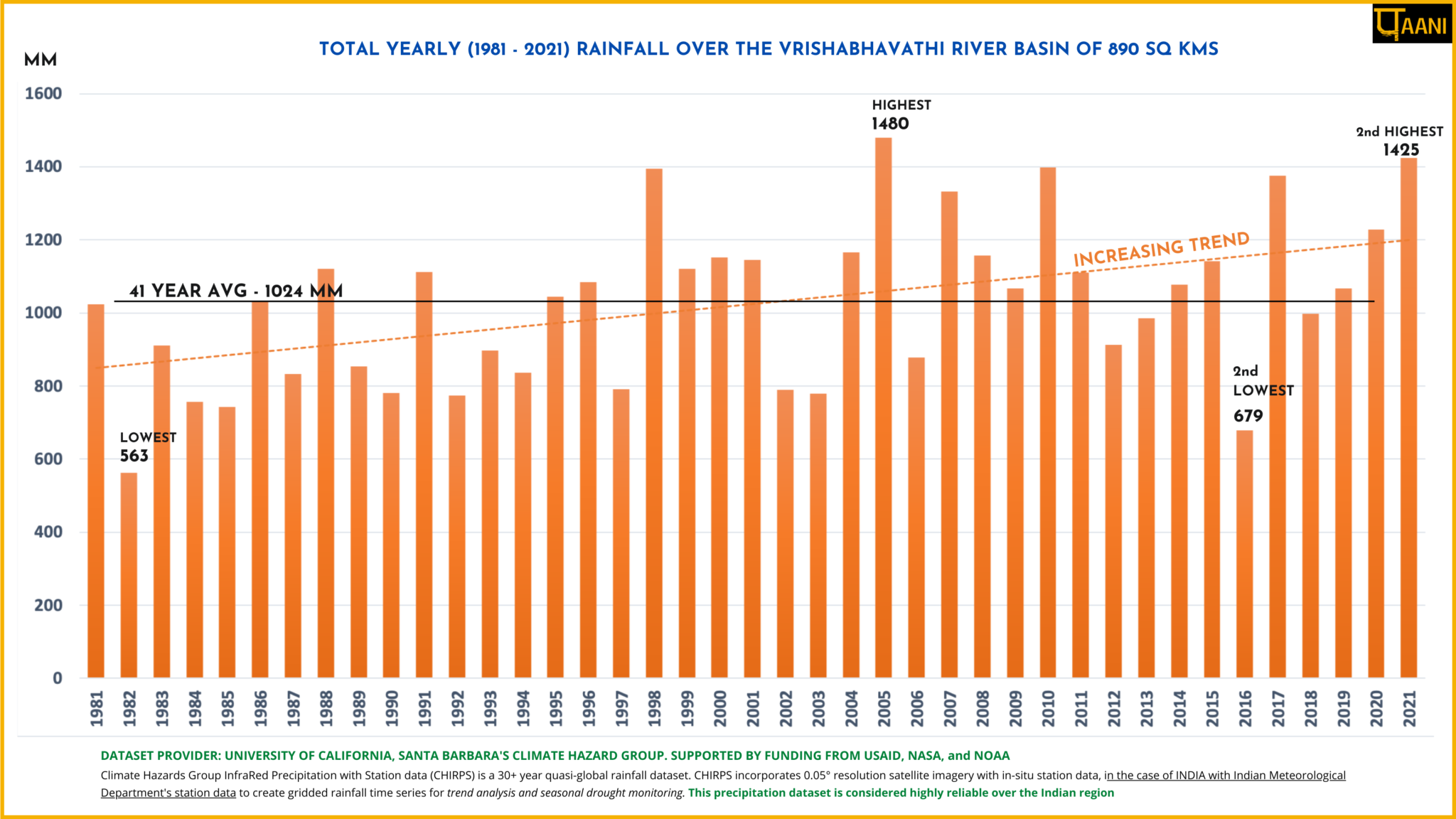
The yearly average rainfall from 1981 to 2021 (sourced from CHIRPS) is plotted on the graph below. According to the graph, the rainfall shows an increasing trend with a 41-year average at 1024 mm. The highest yearly rainfall of 1480 mm was in the year 2005, with the second highest being 1425 mm in 2021. Total yearly rainfall exceeding 1400 mm has occurred post the year-2000 and the lowest amount of rainfall is recorded at 563mm in 1982.
Groundwater status of the river basin
The Central Ground Water Board (CGWB) assesses the stage of groundwater development/extraction by taluks and classifies it as Safe, Semi-Critical, Critical and Overexploited (OE). Administratively, Bengaluru North, Bengaluru south and Anekal taluks are in Bengaluru District, while Ramnagara and Kanakapura Taluks are in Ramnagara District. The river basin spread across 5 taluks is completely overexploited, as shown in the image.

An effort to make people aware
The data points presented along with the map is fundamental in building public consciousness to understand Vrishabhavathi River conservation and protection needs. It is of relevance to policymakers, lawyers, researchers, academicians, students, and citizens.
This is Paani.Earth's effort to democratize data for informed opinions and, most importantly decision making on matters related to rivers.
About Paani.Earth
Paani.Earth was launched early this year, with an intention of empowering citizens with maps, data, information, and analysis for the conservation of rivers. It was founded by three individuals from diverse backgrounds:
Nirmala Gowda is a Computer Engineer with an M.sc in Environmental Management from the University of San Francisco. She last worked for Novartis Pharmaceuticals in the US.
Dr. Nidhi Paliwal is dentist with 15 years of clinical practice including Manipal hospital.
Madhuri Mandava is an Electronics and Communications Engineer with an M.S in Electrical Engineering from the Pennsylvania State University. She last worked for Hughes Network Systems in the US.
The article was first published on Paani.Earth here and has been republished with the author's permission.
/articles/visualizing-vrishabhavathi-river-keep-it-alive