Maps

Term Path Alias

/sub-categories/maps

Fluid rivers but concrete mindsets
Flooded rivers may be a problem in Bihar, but diverting them is not a solution; neither is building embankments. Example: Sitamarhi. Posted on 25 Mar, 2014 08:42 PM

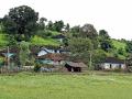
The twin sisters:  Bihar is a land of fertile farms bearing sugarcane, wheat, rice, gram and pulses. Interspersed between the fields are venerable mango groves. Of Bihar's children, perhaps none is as universally loved as Sita. The village that she was born in -Sitamarhi- welcomed another daughter along with Sita.

The old course Lakhandei at Sitamarhi
Mapping land and water resources in India
With rare maps of India including 'Annual Rainfall' map, 'Water Balance' map and 'Land Use' map, the land and the water resource development atlases are excellent sources of information. Posted on 27 Jan, 2014 01:18 PM

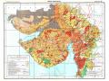
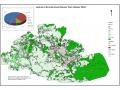
India’s mapping activity dates back to the Indus Valley Civilization (c. 2500–1900 BCE) as per the famous geographer, Joseph E. Schwartzberg. His work is based on a couple of surveying instruments and measuring rods that were excavated from the Indus valley sites. Our mapping traditions were influenced by Vedic, Tibetan, Islamic and more recently, British cartography.

Water resources development in Gujarat (NATMO)
A peak at the future: Simulating Coonoor’s water situation
Using computer simulation, Keystone Foundation demonstrates the impact of domestic use, tourism, plantation and farming on the water situation in Coonoor in the Nilgiris. Posted on 23 Dec, 2013 03:40 PM

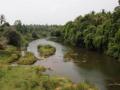
The Nilgiris have undergone an incredible amount of change in the last 10 years. Coonoor, an area well endowed with natural resources, is the second largest tourist destination here. However, over the last year (2012-13), the town has been reeling under a water crisis [1].

Coonoor Land Use Map
Development or displacement?
The MP government is proposing a nuclear project in Mandala district. Villagers are wary about promises to rehabilitate since similar promises are yet unfulfilled to the Bargi dam oustees since 1990. Posted on 01 Dec, 2013 08:30 PM

Sukal Singh is 50 years old and is the only earning person of his five-member family. Suresh Barman works as a labourer supporting a 13-member family. Bhagirat and Gorelal Bhavedi are rickshaw-pullers supporting a 7-member family each.

Bargi dam affected Patha village, MP
Floods need not equate disasters
A mix of high-tech and low-tech systems, government initiatives as well as a community level approach is needed to manage floods in the Himalayas. Posted on 24 Nov, 2013 11:19 AM

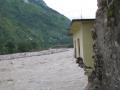
 Every year, we have about 76 disasters in the Himalayas, some 36,000 people are killed and over a million affected by disasters. The loss of life and damage does not need to occur. How people manage the situation can relieve the situation much better.

About a third of these disasters are from floods. In the Himalaya, there are two broad kinds of flooding:

Do floods have to cause loss?
A tale of two STPs
In Lucknow, two sewage treatment plants ostensibly prevent pollution of the river Gomti but are they really doing their job? The photos tell the entire story. Posted on 20 Sep, 2013 04:51 PM

The venerable Imperial Gazetteer says, 'Viewed from a distance Lucknow presents a picture of unusual magnificence and architectural splendour, which fades on nearer view ...' (Imperial Gazetteer of India, v. 16, p. 196).

The only working STP in Lucknow -Daulatganj
Tug of war on the Gomti
A river, which once unified people, is now being manipulated in the name of 'river conservation'. All it is, is an excuse to create a divide and further caste conflict. Posted on 29 Aug, 2013 02:44 PM

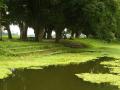
As temple tanks go, this one is quite beautiful. It is a rectangular masonry-lined tank, about the size of a badminton court. Brick steps lead down to the water. On one of its longer sides is a lovely old temple, shaded by mango trees. Groups of men and women sit and gossip in the coolness. Facing them is an avenue of large trees, below which sit contemplative buffaloes.

Gomat Taal is reputedly the source of the Gomti
Post-monsoon celebrations
This photo essay captures the range of activities post-monsoon in rural areas of Maharashtra including the celebration of the Vatapoornima festival. Posted on 25 Jul, 2013 04:38 PM

June signals the start of the monsoons in many parts of India. Pune and its surrounding areas in Maharashtra have witnessed heavy showers since the first week of June. The rains let up for a weeks time during which I visited a few places on the outskirts of Pune city.

Ready to plough his fields
Cool off at Kuruvadweep island
This photo essay showcases Kuruvadweep island, a picture- perfect summer getaway in Kerala. Posted on 05 Jun, 2013 12:09 PM

Wayanad Map - Kuruwa DweepWhat’s the best way to find out if a spot is ‘touri

The Kabini as it flows through Wayanad (Source: Seetha Gopalakrishnan, IWP)
Certificate programme on village GIS software, IIT Madras & WASSAN, Chittoor (AP), July 22-26, 2013
A hands-on field-based workshop on the free, high quality & user-friendly ‘Quantum GIS’, for use by grass root level village workers in developmental activities.
Posted on 02 Jun, 2013 04:51 PM

IIT Madrras

×