Maps

Term Path Alias

/sub-categories/maps

Maps depicting the arsenic contamination in the Ganga-Meghna-Brahmaputra plains between 1976 and 2008
Arsenic is one of the major contaminants of Groundwater in India today, posing a severe health risk to a majority of the population. Posted on 20 Aug, 2009 06:11 PM

The School of Environmental Studies - Jadavpur University (SOES-JU), has done path-breaking research in reporting and documenting the issue of Arsenic contamination in the country.

India - AMS topographical map - Series U502 - U.S Army Map Service (1955)
Download the full size index topographical map of India and Pakistan from the University of Texas's Perry Castaneda Map Collection link provided below Posted on 20 Aug, 2009 05:22 PM

Topographical maps are crucial while planning and implementing watershed development programs. In India, these are available from the Survey of India, Dehradun.

Mapping water pollution and groundwater depletion due to industrial activities in India
This map from Down To Earth indicates that most of India's industrial zones are in water stressed regions, hence water prudence on the part of Industries become crucial Posted on 20 Aug, 2009 04:28 PM

This map provides the of levels of water pollution and groundwater depletion due to industrial activities in different parts of India. 

Mapping the soils of India: Survey of India
A detailed map on the different soil types in India from the premier mapping organization of the country, Survey of India Posted on 20 Aug, 2009 04:11 PM

Soils constitute the upper portion of the earth's crust, and are the base of human habiation on the earth. India has a great variety of soils, with over 29 major types.

The map can be accessed from the Survey of India website

Download the map from the link provided below:

Map: Location of water resource projects across river basins in India
This map from the National Institute of Hydrology shows the location of the various water resources projects in each river basin in the country. Posted on 20 Aug, 2009 03:23 PM

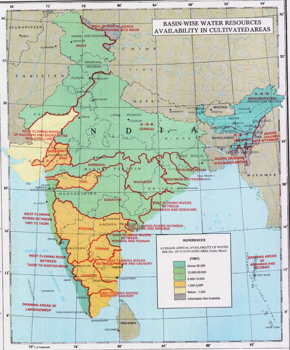
The map indicates that across the main 19 river basins of the country, water resource projects with a total live storage of 174 BCM (Billion Cubic Metres) have been completed, 75 BCM are ongoing, and 132 BCM are being planned.

Annual average availability of water for agriculture in India as of 1991
This map shows the river basin-wise annual average availability of water (in m3) for agricultural cultivation, as of 1991 Posted on 20 Aug, 2009 02:50 PM

/sites/default/files/iwp/Basin-wise%20annual%20average%20availability%20of%20water%20for%20agriculture_1991_NIH.jpg

Map: Average annual temperature in India
This thematic map from Wikimedia Commons provides information about the average annual temperature in India Posted on 20 Aug, 2009 02:15 PM

This map from Wikimedia provides information on the average annual temperature figures across the country over a range of below 20 Deg C and above 27.5 Deg C.

Physiographic rainfall variations across India: Thematic map from the Indian Institute of Tropical Meteorology
This map shows the recent rainfall trends, based on data from 1813 to 2006, and also shows monthly trends for the 4 main rainfall months of the year - June to September. Posted on 19 Aug, 2009 03:59 PM

The map shows that there is a decreasing trend of rainfall over most of peninsular India (barring Maharashtra) including the western part of the Gangetic plain and the north eastern states apart from Assam.

An increasing trend of rainfall has been observed for the eastern part of the Gangetic plain, Assam, Telengana and all coastal regions of the country.

Ozone depletion trend map for India from Down to Earth
This map shows the difference between predicted and observed ozone trends in 14 cities of India, based on data collected over a decade Posted on 19 Aug, 2009 03:52 PM

/sites/default/files/iwp/Ozone%20levels_Difference%20between%20predicted%20and%20observed%20trends%20in%2014%20cities_2005_Down%20to%20Earth.jpg

Map depicting areas prone to flooding in India
A map from Wikimedia Commons showing the areas frequently affected by floods in India Posted on 19 Aug, 2009 03:48 PM

This map shows the regions in the country that are regularly affected by floods.

The major flood prone regions are Punjab, Haryana, most of the Gangetic plains including Uttar Pradesh, North Bihar and West Bengal, the Brahmaputra valley, coastal Andhra Pradesh and Orissa, and South Gujarat.

×