Term Path Alias
/topics/surface-water
/topics/surface-water


Guest Post by: Dinesh Kumar Mishra
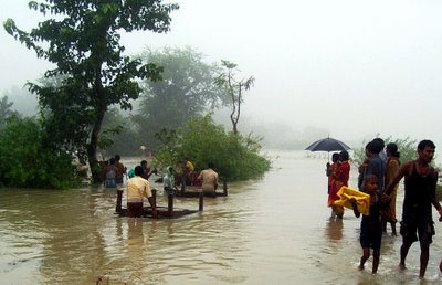
The foundation stone of the Kosi Project was laid on January 14, 1955 amidst fanfare, jubilation and victory. Dr. Shrikrishna Sinha, thgen Chief Minister of Bihar, laid the foundation stone near Bhutaha village close to Nirmali, in Saharsa (now Supaul) district with the chanting of mantras by Pt. Mahabir Jha of Jhitki village and shouting of slogans like 'Aadhi Roti Khayengein, Kosi Bandh Banaayengein.' (We will eat only half a chapati but we will surely build the Kosi embankments). A majority of people lost the other half of the bread too on the 18th August 2008 when the Kosi embankment breached on that day.
Col. Townsend of the US Army while deliberating in a seminar organized by the American Society of Civil Engineers to discuss the Mississippi floods of 1927 had said that even the best designed and carefully constructed embankments remain at the mercy of burrowing animals like rats, foxes, muskrats who can create a hole in the finest levee that has been devised, which if not closed within a few moments will ensure its destruction. The Mississippi River of the United States broke loose in 1927 inundating an area of 51,200 sq. kilometer and damaging property to an estimated extent of two hundred million to a billion dollars. The breaches drove nearly three quarters of a million people from their homes and six hundred thousand of them were dependant on Red Cross. The wealth and power of the United States enabled much to be done for the sufferers, still they suffered. He further added a 'careless supervisor and dark nights' to the list destroyers of embankments. His observations remain valid till date as the Kosi comes out of its shackles in Kusaha in Nepal some 13 kilometers upstream of the Kosi Barrage. All the eight breaches that have occurred so far can be brought under these categories.
Col. Townsend gave benefit of doubt to the planners and engineers when he prefixed 'best designed and carefully constructed' adjectives to the embankments. The Kosi has breached its embankment eighth time and it is for the first time that the 'disaster' has generated so much of interest. These embankments are spaced at an average distance of 9 to 10 kilometers below the barrage with a maximum width of 16 kilometres between Kisunipatti and Bhaptiahi and minimum width of nearly 3 kilometres at the barrage itself. The spacing of the embankments is only 8 kilometres at the tail end, between Baluaha Ghat and Ghonghepur. In Nepal portion the spacing between them is restricted to between 3 to 6 kilometers. Common sense suggests that the spacing between the embankments should increase as the river advances further as more and more streams join the river from western side. This simple common sense was kicked around when these embankments were constructed in late 1950s. There were 304 villages with a population of 192,000 (1951 census) going to be trapped between the embankments and each one of them was trying to be located outside the embankments. Later the embankments were extended and 380 villages of Bihar and 34 villages of Nepal came within them. Their current population is nearly 1.2 million. The village locations were fixed and it was the embankment on either side of the river that could be moved. So did it happen. Now the embankment alignment is a caricature of what it was designed, if there was any design.
The report ( current as on 13th September, 2008 ) provides a concise overview of the daily flood situation, action taken so far and provides detailed statistics on the issue. The report also includes meteorological forecasts and analysis of current and possible flood situations in the different areas of concern.
A very interesting thread has been initiated on the Discussion Forum on the Portal by Bob Eibl.
North Bihar has a long history of flooding.Through a series of posts here, we will attempt to explain the background of flooding in Bihar and what are the root causes.
Courtesy: biharfloodrelief2008.blogspot.com
Dr. Jagannath Mishra, former Chief Minister of Bihar, has given a pathetic description of floods in Bihar. He said that "Nobody from the government has gone to Saharsa so far. If the people in Saharsa are surviving, they must be saying that we are engulfed in water since ten days and nobody is there to think about us. This is quite worrisome. I will suggest that we must try to look after those surviving there. We must try to save them, whether by boats or a helicopter.. The flood in Saharsa is not a flood, this is unprecedented¦.we cannot call it a flood, it is a deluge." But wait, he is not talking about the recent floods (2008) in Bihar. He was making a speech in the Bihar Vidhan Sabha on the 13th September 1984 about a similar incident that took place on the 5th September 1984 near Navhatta in Saharsa district of north Bihar when the Kosi had breached its embankment at 75th kilometer south of the much talked about Bhimnagar Barrage and come out of the jacket just as it happened at Kusaha this year. Obviously, the powers that be refuse to take any lessons from the past mistakes and their executive wing, the Water Resources Department, is immune to any criticism and learning. The 1984 incident had uprooted nearly half a million people from their homes and hearths and engulfed 96 villages spread over 7 blocks of Saharsa and Supaul districts then. They could return to their homes only after the Holi festival in March 1985.
 Key Features: Reviews the risks of inter-basin water transfers warns of critical disadvantages with India's proposed ILR plan offers viable less-risky solutions for water resource development. Inter-basin water transfers are complex human interventions on natural systems that can have profound adverse as well as beneficial social, economic and environmental implications. India's plan to interlink its rivers (ILR) and to transfer water may, according to one set of views, generate positive benefits through improved and expanded irrigation and may also contribute to flood and drought hazards mitigation for India, although the magnitudes are debatable. However, there are opposing views, in the context of India itself, that the interlinking plan is economically prohibitive, fraught with uncertainties, and has potential for disastrous and irreversible adverse after-effects. Water deficit can be reduced through improved water management without large scale engineering interventions. Moreover many of the rivers involved, particularly in the Himalayan component, are international and, therefore, the scheme has major implications for other riparians. Indeed, the planned transfer of water from the Ganges and Brahmaputra rivers will adversely impact Bangladesh socially, economically and environmentally---unless arrangements are made to maintain historical flows, which is unlikely to be feasible.
All is not well with the High Level Expert Group (HLEG) constituted on an order of the Government of India to determine the flow required to keep the Bhagirathi river 'alive and to ensure perennial environmental flow in the river'. It may be recalled that on June 30, 2008 the Government of India committed itself to "suitably ensure perennial environmental flow in all stretches of river Bhagirathi."This commitment was made in response to a representation of the Alumini Association of IIT- Kanpur to the Prime Minister of India requesting his intervention in the fast-unto-death undertaken by Dr. G.D. Agrawal , a former Dean of IIT-Kanpur -- to ensure the natural and uninterrupted flow of the Bhagirathi river between Gangotri and Dharasu (Uttarkashi). Subsequently the Ministry of Power, GoI, directed Shri R.S. Sharma, Chairman & Managing Director of NTPC, to constitute a high level expert group. The biggest problem with the HLEG is that it lacks the necessary scientific expertise to comprehensively address the issue. In a letter to Shri R.S. Sharma, rejecting his invitation to be a member of the HLEG, Dr G.D. Agrawal wrote, "Several members of the HLEG as constituted (including its Chairman) fall extremely short on any sort of expertise on river ecology and environmental flows...The commitment of most proposed members towards conservation of Bhagirathi Gangaji as the mother of India's faith, unity and culture is also questionable and I cannot afford to provide credibility to its deliberations and conclusions by being an ordinary member of the group."
About the Report: The flood situation report has been a joint effort of Megh Pyne Abhiyan's (literally clouds' water campaign, involving people around the issue of water and livelihood, and a functional network of grassroots organizations) partners - Gramyasheel, Supaul; Kosi Seva Sadan, Saharsa; Samta, Khagaria, Ghoghardiha Prakhand Swarajya Vikas Sangh, Madhubani; SAVERA, West Champaran; Luisa Cortesi and Eklavya Prasad in assistance with Santosh Jha of Gram Bharti, Raghopur.Supaul. For compiling the situation report, two days of field visit was undertaken by the team, involving extensive interaction with affected villagers from India and Nepal, discussion with members of civil society groups, deliberations with government officials (Sub Divisional Magistrate and Dy Superintendent of Police, Tribeniganj; District Magistrate, Supal) and internal exchange of idea between the partners of Megh Pyne Abhiyan (MPA) and the supporting organizations. During the field visit, the group started to explore the option of establishing a district level coordination group comprising of eminent personalities and professionals, representatives of non governmental organizations and media, to coordinate and steer the rescue and relief work with individuals, government agencies, non government organizations, donor agencies, corporate bodies etc. Hence, on 25th August during a district level meeting of local organizations, activists and donor agency, a consensus was reached to set up a coordination group, named as the Flood Action Coordination Group (FACG), Supaul.
General overview of the River: On the 18th of August the eastern embankment of Kosi near Kusaha in Nepal's Sunsari district breached. The breach itself has caused colossal loss of life and property in the south east tarai region of Nepal and in six districts of north Bihar, affecting more than 2.5 million human lives. After the breach, the river has shifted its course nearly 100 kilometres (kms) eastward from its earlier course (which use to pass through the districts of Supaul, Saharsa, Madhubani, Darbhanga and Khagaria).
Access the entire report:
Home to more than 13 million people, Mali stretches from the Sahara Desert in the north to the semiarid grassland known as the Sahel in the south.
