Mahatma Gandhi National Rural Employment Guarantee Act (MGNREGA) is currently the largest funded rural development program in India to ensure rural livelihood by providing employment through different activities. Owing to climate change impacts and water scarcity for the last 5 years, approximately more than 70% of activities (budget of 5 billion USD per year) are focused on water issues.
For better utilization of resources, MGNREGA has been implementing these works in convergence with many other schemes like the integrated watershed management programme (IWMP), with the aim of restoring rural natural resources, like soil, vegetation, and water. Although the largest Rural Development Scheme in India, the monitoring and evaluation (M&E) does not focus on the actual impact on water resources but only focuses on the amount spent. This can lead to only information on funds spent but does not have much an impact on water resources and earmarking data for monitoring.
To track the implementation and outputs systematically and measure the effectiveness of the program, the Ministry of Rural Development and National Informatics Center developed the DISHA dashboard. The DISHA dashboard helps Members of Parliament (MPs), Members of the Legislative Assembly (MLAs), and district officials to track the performance of the scheme in their districts and constituencies at any geographic level and at any time period to enable data-driven decision-making.
Instead of being the largest funded scheme, most of the monitoring under the DISHA dashboard is inclined to the assessment of fund spending, employment generated, and the number of works completed, but to draw maximum benefits out of the program, there also needs to be a rigorous post-implementation monitoring and impact assessment of assets created to restore natural resources and increase productivity (Chakraborty and Das, 2014).
Traditionally, impact assessment works of MGNREGA are carried out with the help of sample surveys by government agencies such as the National Sample Survey Office (NSSO), which collects data from 12,784 first-stage units (FSUs) comprising 1.5 crores of the population at the national level (National Sample Survey Office, 2015).
Apart from this, recently, the Comptroller Auditor General of India (CAG) evaluated the effectiveness of Jalyukta Shivar Yojana, a state version of IWMP-MGNREGS based on sample data from 120 out of 63,363 villages in Maharashtra (Comptroller Auditor General of India, 2020), but the major problem in such type of impact assessments is the small sample size, huge underlying cost, efforts, time consumption, and reliability of the results with a given sample size, which may not holistically map the effectiveness of the program.
This creates a need to develop a comprehensive, low-cost, reliable, and robust M&E framework to assess the impacts and effectiveness of the program in restoring natural resources (Department of Land Resources, 2018).
The recent advancements in remote sensing techniques have provided open access to high-resolution satellite data along with the processing platform. Considering the available technologies and gaps in the existing M&E framework, the current study ‘Index-based impact monitoring of water infrastructures in climate change mitigation projects: A case study of MGNREGA-IWMP projects in Maharashtra’ published in the journal Frontiers developed a low-cost, comprehensive, robust, and near real-time M&E framework to assess the impact of water projects.
The spatial and temporal change detection for a region's water and ecological status is difficult due to fewer observation data. Hence, most new water resource infrastructures are not evaluated and therefore less space for increasing efficiencies. To overcome this limitation, the study developed a prototype method by employing the remote sensing-based ecological index, that is, RSEI.
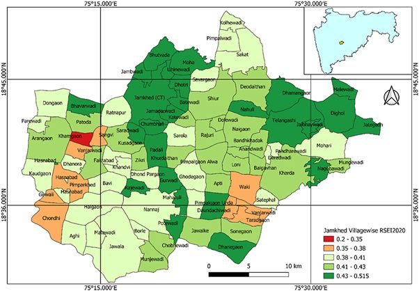
RSEI can assess the overall ecological status of land surfaces due to the water infrastructures developed. The performance of RSEI has also been assessed using the secondary data of crop production, which shows excellent results (adjusted R2 value of 82% and Pearson's correlation coefficient of 0.92).
In addition, RSEI results were compared against the results of government audits (e.g., by the Comptroller Auditor General of India), wherein RSEI found similar areas of increased water status and crop productivity. The results indicate that the use of the RSEI-based M&E framework will allow for an impact assessment of water infrastructure and also aid to identify the priority areas demanding immediate intervention. Thus, RSEI can be used as a decision support system for stakeholders, including for smooth planning, designing, implementation, monitoring, and evaluation of water infrastructure for combating climate change extremes such as droughts.
The RSEI technique makes distinctions among different water availability and ecological change-related approaches using individual indices because the result of the RSEI approach is not only provided with a single numeric value but also a comprehensive image that illustrates the spatial difference of regional water and ecological conditions. This status image will help to make change detections spatially and temporally as demonstrated for the Ahmednagar district, which otherwise would be difficult with the current non-availability of data.
Currently, available high-resolution satellite data have been widely used for creating such indices, and this study used an aggregate index to establish a tool for the periodic monitoring of projects at a large scale. The newly developed RSEI framework, with a spatial resolution as high as 10 m and a temporal resolution as long as 10 days, respectively, with the satellites such as Sentinel-2A, was tested for field sites with the available data.
The analysis of CAG's audit shows that the MGNREGS-IWMP projects have not generated the desired outcomes in the study areas of Ahmednagar in Maharashtra. The use of the RSEI framework for the same site also demonstrated that the results in line with CAG's findings. In addition, the RSEI helped to identify the areas with the poor performance of projects and provide an opportunity for data-driven decision-making and intervention design. The RSEI based on open-source remote sensing big data has enabled the near real-time, comprehensive, robust, unbiased, and low-cost monitoring of the projects to provide a decision support system for decision-makers to ensure that the resources will be utilized in the right place, at the right time, and for the right cause.

The RSEI has been effective in monitoring the actual impacts of the MGNREGS-IWMP (WDC-PMKSY) projects in improving the ecological status of the region, with an adjusted R2 value of 82% and Pearson's correlation coefficient of 0.92. The RSEI framework demonstrated the results in line with CAG's findings, and it helped us to identify the areas with the poor performance of projects at a large scale.
The analysis of controlled vs. applied sites shows that the applied site, that is, the Ahmednagar district with 20,028 MGNREGS-IWMP projects, has generated no additional benefits toward the restoration of natural resources and improvement of productivity of a region. Contrary to that, the Solapur district with just 2,800 MGNREGS-IWMP projects has shown an annual increase in productivity of 6% against 3% for the Ahmednagar district.
The findings from the secondary and remote sensing data seriously question the need, implementation and methodology of the MGNREGS-IWMP program, which are in line with the government's individual audits. This type of M&E framework will definitely help the stakeholders from gram panchayats, district officials, state, and national levels for improving the performance of water resource management structures and also in wisely using funds.
To build a robust adaptation program, there is a need for a robust monitoring mechanism to assess the impact of implemented projects and suggest corrective measures for future program implementation. As the RSEI helps to assess the ecological condition such as drought and its impact on crop production, it provides the decision support system for adaptive and corrective program implementation for building climate adaptation.
The RSEI-based M&E framework helps to identify the problematic project sites, but it needs ground-truthing data to further investigate the issues in the projects/assets created. The set and number of spectral indices to be used in the RSEI model can vary from region to region based on regional agroclimatic conditions. Hence, the RSEI model needs to be modified for different regions.
The full paper can be accessed here
/articles/index-impact-monitoring-water-infrastructure