The Nasa Earth Observatory
The Nasa Earth Observatory
NASA study finds earth's lakes are warming
Posted on 01 Dec, 2010 11:14 AM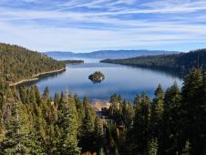 Lake Tahoe, seen here from Emerald Bay, was one of the primary validation sites for the global lake study. Image credit: NASA/JPL-Caltech
Cyclone Aila 2009
Posted on 01 Jun, 2009 11:27 AMTropical Storm Aila struck southern Bangladesh and eastern India on May 27, 2009. The New York Times reported that floods and mudslides killed at least 191 people and left hundreds of thousands more homeless. As of May 27, the death toll was expected to rise. Images from The Nasa Earth Observatory.

The Moderate Resolution Imaging Spectroradiometer (MODIS) on NASA's Terra satellite captured this true-color image of Aila on May 25, 2009, the same day that the storm temporarily strengthened to a Category 1 cyclone. Aila almost completely fills this scene, stretching from the Bay of Bengal deep into India, Bangladesh, and Burma (Myanmar). On May 25, Aila's wind speeds ranged from 74 kilometers per hour (46 miles per hour or 40 knots) to 120 kilometers per hour (75 miles per hour or 65 knots). More information and detailed images can be accessed here:Cyclone Aila
Northern Antarctica's Wilkins ice bridge collapse - Images
Posted on 14 Apr, 2009 04:10 AMA narrow ice bridge connecting Charcot Island and Latady Island ”the last remnant of the northern part of Antarctica's Wilkins Ice Shelf broke apart in early April 2009. These photo-like images, from the Moderate Resolution Imaging Spectroradiometer (MODIS), show the break-up of the ice bridge.
Drying of Lake Faguibine, Mali:Report by UNEP
Posted on 14 Aug, 2008 09:30 AMHome to more than 13 million people, Mali stretches from the Sahara Desert in the north to the semiarid grassland known as the Sahel in the south.
Algal bloom along the coast of China
Posted on 17 Jul, 2008 09:52 AMOn June 28, 2008, the Moderate Resolution Imaging Spectroradiometer (MODIS) on NASA's Aqua satellite captured these images of Qingdao and the bay of Jiaozhou Wan. It shows the officials and residents of Qingdao (also known as Tsingtao) struggling with a stubborn adversary: algae. The top image is a natural-color image similar to what a digital camera would photograph.
Bird's eye view of Lonar crater in India
Posted on 17 Apr, 2008 08:46 AMBelow in the link to an image of the Lonar Crater in India, captured by the Advanced Spaceborne Thermal Emission and Reflection Radiometer (ASTER) flying on NASA's Terra satellite. It was identified in 1823 by a British officer named C.J.E. Alexander, it sits inside the Deccan Plateau a massive plain of volcanic basalt rock leftover from eruptions some 65 million years ago.