Term Path Alias
/topics/surface-water
/topics/surface-water


Guest Post by: Amitangshu Acharya The Umiam Lake Conservation - Stakeholder Dialogue and Future Strategies was held on 9th and 10th March 2009 in Shillong. The presentations and some videos from the conference can be viewed here -https://www.indiawaterportal.org/data/conf/ULC.html To give help learn more about the Lake Umiam in Shillong, here is a backgrounder about Lake Umiam and its importance to Shillong. You can join the discussion forum about Umiam Lake here https://www.indiawaterportal.org/Network/forum/viewtopic.php?t=3044 Umiam Lake ( also known as Barapaani) originated as an artificial reservoir for the Umiam Umtru Hydro Electric Power project, the first of its kind in the North East. For a long time, this project had supplied the bulk of its power needs to the State of Meghalaya. The state's love affair with this lake spans 43 years. With approximately 12,000 mm of rainfall each year and a catchment area of 221.5 sq km (almost double the size of Chandigarh) Umiam rarely saw any dry days. Until now, that is. For two years now, Shillong has confronted one of the worst power crises ever. The reason is not hard to imagine: Umiam doesn't have enough water. Officially, inadequate rainfall has been cited as the sole reason, and a correlation does exist between decreasing water levels (about 39 feet over 3 years) in the lake and lesser rainfall since 2005. And once the water level falls below 3150 feet, there can be no power generation. However, the question is, whether the role of rainfall is being overplayed while the other issues remains unaddressed.
Culture and places of historical significance
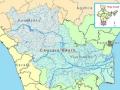
The river Cauvery has been the inspiration for various civilizations who have thrived on the banks of the river. This can be seen manifested in the various forms of art, culture and philosophy that have originated along the course of the river.

The latest loss figures (24 Feb. 09 is five districts, 35 blocks, 33.29 lakh peopla, 9.97 lakh live stock., affected area 3.68 lakh hectares, 2.37 lakh houses, 527 human death a and 19,323 loss of cattle.
The following is a paper by Dr. Mohinder Slariya based on data collected during his Ph.D work. The work contains data sourced from the India Water Portal, and aims to illustrate local area climate changes with the development of hydroelectric projects. The abstract of the paper has been quoted below, with the full paper available as a download!
Abstract
Dams have had serious impacts on the lives, livelihoods, cultures and spiritual existence of indigenous, tribal and illiterate people, moreover on the physical environmental conditions and on the biodiversity of the area concerned. The dam related developmental activities in Ravi catchment area have been threatening the biodiversity in the whole catchment. There are more than 50 rivulets in the Ravi catchment and on which more than 70 power projects have been planned by the government by putting biodiversity at the stake. Developmental activities have unintentionally produce weather and climate modifications on a larger scale and threaten the existing biodiversity. Such developmental activities have been started day back in 1980s in Ravi basin with the installation of Baira Suil Power Project and today it has covered all most all Ravi basin starting from interstate broader of Jammu & Kashmir, Punjab and Himachal Pradesh and engulfed the green cover of the area. Because of this extinction the catchments area is experiencing drastic climatic changes, because of 100 km reservoirs of Shahpur Kandi (125MW), Thein Dam (600MW), Chamera-I (540MW) and Chamera-II (300 MW) and tunnelization of Ravi in 19.38 kms with a dia of 7 to 9 meters and 102 meters high surge shafts with 15.5 meters dia and underground power houses of Chamera-I & II and dry Ravi in almost all its natural route (27 kilometers in Chamera I & II). In this dry region there is a tremendous increase in the temperature and there is no timely and usual rain in the basin after the installation of power projects.
"If it had not breached at Kusaha, it would have anyway breached at this point," points a villager towards the probable location on the eastern bank in village Rajabaas near Prakashpur in Sunsari district of Nepal, located 14 km upstream of Kusaha where the Eastern Afflux embankment of the Kosi had breached on the August 18, 2008.
The Orissa River Conference is being held from April 18 - 20, 2009, Sambalpur, Odisha.
India River Network (IRN) and Water Initiatives Orissa (WIO) invite you to a three day long Orissa River Conference. Rivers are in stress and dying. Odisha is no exception. All of its rivers including major rivers Mahanadi, Brahmani are dying of quantitative and qualitative degradation and decrease. Water salinity in the lower Brahmani has gone up as river flow has almost stopped in crucial summer months. Water flow in the Mahanadi River too is decreasing at a rapid rate. A comparison between second half of the post Hirakud dam period with the first half shows about 15 percent of decrease in average annual flow. Other rivers like Baitarani, Subarnarekha, Vanshadhara, Rushikulya and Nagabali etc. are also suffering the same fate. The problems are manifold. Unsustainable growth of population; industrialization led pollution; climate change and many other problems have virtually wrecked havoc on the fate of the rivers. The rivers are dying and are surely spelling doom for the civilizations around them.
Send to the Portal by Divya Mishra Assistant Editor FlyteLite ========== I handle a magazine called FlyLite (which is the in-flight magazine for JetLite) and for our April issue, we're carrying a story on the dams and bridges of India. We are currently looking for images for the following structures: 1. Gandhi Setu, Patna 2. The Grand Anicut Dam, Tamil Nadu 3. Idukki Dam, Kerala 4. Hirakud Dam, Orissa 5. Krishna Raja Sagara Dam, Karnataka
The Water Portal will be participating in an event at Madiwala Lake in Bangalore on Sunday March 22nd. The event will raise awareness about the benefits of Madiwala Lake and the problems facing the lake. A proposal will be made to construct a bicycle track around the lake which will have several benefits including reducing encroachment.
 Author: Jayanta Bandyopadhay, Indian Institute of Management, Calcutta Published: April 2009 Pages : 212 Imprint : SAGE India Water, Ecosystems and Society is an excellent guide to interdisciplinary knowledge on water. It draws attention to ecological benefits of floods, economic productivity of water systems and the feasibility of the proposed river-link project of India. It focuses on the need to recognise ecosystem services provided by rivers as well as the necessity of environmental flows in such a system. The book deals with emerging areas of research, by connecting ecology, economics and water management. It will be a compelling read for academicians and students working in the fields of geography and environment science, development economics, environmental sociology, ecology, integrated water management and so on.
