Indian Space Research Organisation (ISRO)
Indian Space Research Organisation (ISRO)
River basin atlas of India – A report by Central Water Commission and Indian Space Research Organisation
Posted on 10 Feb, 2013 01:12 PMThis publication by the Central Water Commission (CWC) and Regional Remote Sensing Centre – West, Indian Space Research Organisation (ISRO) presents the status of water resources development in each of the river basins as per CWC classification. It was launched on November 1, 2012 by Minister of Water Resources Shri. Harish Rawat in a function organized at CWC, New Delhi.
This comprehensive publication gives detailed information of major water resources projects along with the location of all hydrological observation sites including major dams, barrages etc. in all the river basins of India.
This "River basin atlas of India", an outcome of joint project “Generation of Database and implementation of web enabled Water Resources Information System (India-WRIS) in the country”, is a publication by the Central Water Commission (CWC) and Regional Remote Sensing Centre – West, Indian Space Research Organisation (ISRO) that presents the status of water resources development in each of the river basins as per CWC classification. It was launched on November 1, 2012 by Minister of Water Resources Shri. Harish Rawat in a function organized at CWC, New Delhi.
This comprehensive publication gives detailed information of major water resources projects along with the location of all hydrological observation sites including major dams, barrages etc. in all the river basins of India. All these features have been portrayed on the maps with river network, major cities and terrain in background. The hydrological and Flood Forecasting observation sites of Central Water Commissions are also marked in the basin maps.
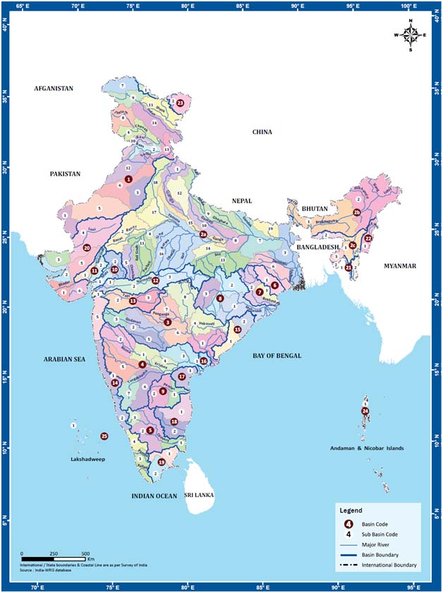
India-WRIS Sub-basins, Source: River basin atlas of India, CWC and ISRO, 2012
The Government of India adopts the Remote Sensing Data Policy (RSDP), 2011: A policy released by ISRO
Posted on 07 Jul, 2011 08:31 PM
Desertification and land degradation status mapping of India - A paper by ISRO
Posted on 20 Apr, 2010 04:12 PMThis paper by ISRO broadly deals with desertification and the process of land degradation in arid, semi-arid and dry sub-humid areas. It describes the classification system, methodology and results of the desertification & land degradation status mapping carried out for the entire country on 1: 500,000 scale using multi-temporal Resourcesat AWiFS data. The dominant processes of land degradation, viz. water erosion, vegetal degradation, wind erosion, salinization, waterlogging, frost heaving, frost shattering and mass movement have been deciphered and mapped using satellite data.