It is therefore crucial that we look after this resource and ensure that it is managed properly.Over reliance on groundwater for both domestic and commercial purposes has led to over-exploitation and contamination of groundwater. In order to make groundwater sustainable, there is a need to understand the aquifer characteristics as well as its overall geological setting. This understanding will help in:
- planning regulated use of groundwater
- planning suitable mechanisms for groundwater recharge

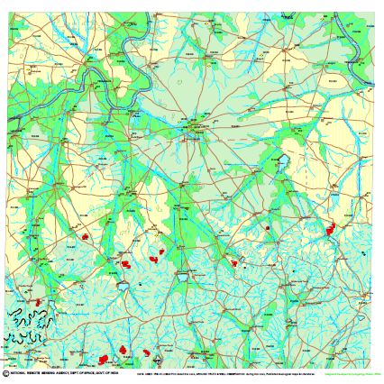
Groundwater prospects map, based on satellite image interpretation with limited field checks, of a part of Adilabad, Andhra Pradesh and Nanded, Yavatmal districts of Maharashtra, corresponding to Survey of India's toposheet number 56E15
There are large number of habitations yet either Not-Covered (NC) or Partially Covered (PC) with potable water supply schemes mainly because the potential locations for the occurrence of potable groundwater could not be identified in the immediate vicinity of such habitations. In the recent times, even the covered habitations are also slipping back to NC and PC categories due to drying up of existing wells.
To overcome these problems in the drinking water supply schemes and achieve sustainability of drinking water sources through artificial water recharge, surface impoundment/percolation, rainwater harvesting etc, it is essential to prepare hydrogeomorphological (HGM) maps using satellite data.
These maps aim to support State Governments to identify correct locations of sustainability structures and also to help locate high yielding, sustainable borewell or tubewell locations, considering hydrogeological information of the region.
With this intent, the Ministry of Drinking Water and Sanitation in collaboration with the National Remote Sensing Agency (NRSA) , now renamed National Remote Sensing Centre ( NRSC), under Rajiv Gandhi National Drinking Water Mission Programme (RGNDWMP), has prepared groundwater prospects maps based on hydrogeomorphological maps (HGM) of the region, for the following states:
- Andhra Pradesh
- Assam
- Chhattisgarh
- Gujarat
- Himachal Pradesh
- Jammu and Kashmir
- Jharkhand
- Karnataka
- Kerala
- Madhya Pradesh
- Orissa
- Punjab
- Rajasthan
- Uttarakhand
Similar maps are under the process preparation for the remaining states and union territories - Tamil Nadu, Goa, Maharashtra, Manipur, Nagaland, Arunachal Pradesh, Mizoram, Sikkim, Meghalaya, Tripura, West Bengal, Delhi, Haryana and Uttar Pradesh and these are expected to be completed before the end of year 2013.
Hydrogeomorphology is the science relating to the geographical, geological and hydrological aspects of water bodies and changes to these in response to flow variations and to natural and human-caused events.
The groundwater prospects maps contain comprehensive data on groundwater using remote sensing technology and Geographic Information System (GIS). Further the maps serve as a reference database for identifying potential locations both for drilling wells and constructing recharge structures specific to the site.
The maps have information on:
- Map units
- Geological sequence / rock type
- Geomorphic unit / landform
- Depth to water level in summer / pre-monsoon
- Number of wells observed
- Recharge conditions - based on availability of water from rainfall and others sources
- Groundwater prospects
- aquifer material
- type of wells suitable
- depth range of wells
- yield range of wells
- homogenity and success rate of wells
- quality of water
- groundwater irrigated area
- Recharge structures suitable
- Hydrological information
- Structural information
- Base map information
- Location information as per the Survey of India's toposheet map index
The manual will be of use to all field level implementing agencies, planners, researchers and monitoring agencies in managing ground water based drinking water sources effectively. The manual provides information on:
- the map contents
- scientific rationale behind preparing the contents
- referencing of the contents on the ground
- usage of the maps in the field
In the backdrop of this programme, a national level workshop is being organised at NRSA on 17 and 18 January 2013. The aim of this workshop is to peer review the status of groundwater prospects map, update the HGM maps completed in earlier phases and to introduce a groundwater quality layer, into the current groundwater prospects maps. To view the programme schedule of the workshop, click here.
To download the maps, click here.
Download a manual on how to use these groundwater prospects maps.
Editor's Notes:
The published article has been edited on January 11, 2014, to correct the organisation name 'National Remote Sensing Agency (NRSA)' to its current name 'National Remote Sensing Center (NRSC)', thanks to feedback from a reader.
/articles/ministry-drinking-water-and-sanitation-and-national-remote-sensing-centre-release