Balachander T
Balachander T
Empowering rural development through geospatial technologies
Posted on 15 Feb, 2024 04:20 PMThe simplification of access to the Global Positioning System (GPS) via smartphones, along with mapping solutions built to leverage these in the form of easy-to-use apps, has contributed to the widespread adoption of geospatial technologies in the rural landscape.
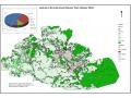
Categorising watersheds for freshwater ecosystem conservation in India
Posted on 25 Nov, 2022 04:20 PMWe invite your feedback and contributions to this article. Please view the maps by clicking the link at the end of the article.
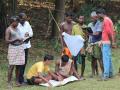
Water works: Keystone’s interventions in the Nilgiris
Posted on 07 Apr, 2014 12:50 PMA village of nine families bounded by a river on one side and thick forests on the other, lived here in Kilcoupe, an Irula hamlet in the Nilgiris. The women went out into the forest in search of water, a risky activity, as there was quite a large chance that they would encounter either a gaur or an elephant, sometimes even a leopard.
My experience with e-learning courses
Posted on 20 Feb, 2014 12:55 PMThe Internet and mobile revolutions have combined to give birth to whole new generations of tools that put skills that were squarely in the domain of specialists a decade ago, in the hands of laypersons and amateurs.
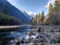
A peak at the future: Simulating Coonoor’s water situation
Posted on 23 Dec, 2013 03:40 PMThe Nilgiris have undergone an incredible amount of change in the last 10 years. Coonoor, an area well endowed with natural resources, is the second largest tourist destination here. However, over the last year (2012-13), the town has been reeling under a water crisis [1].