Term Path Alias
/topics/surface-water
/topics/surface-water


The paper sets forth for consideration a broad national perspective on the nature of water and on its prudent, wise, sustainable, equitable and harmonious use. The Ministry of Water Resources is at present engaged in revising the National Water Policy 2002. Iyer is of the opinion that instead of trying to make changes in the 2002 Policy, the Ministry should put it aside and draft a new policy, starting from first principles.
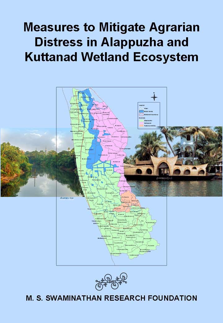 In spite of its natural wealth, the Alappuzha district has a high proportion of population living in poverty.
Recognizing that the process of preparation of a mitigation plan report is as important as the product, the MSSRF team held wide ranging consultations with all concerned with the economy, ecological security and livelihood security of Kuttanad wetlands. Information on the consultations held and visits made are given in the report. It contains a malady-remedy analysis of the problems and potential solutions.
The greatest challenge in dealing with multidimensional problems in our country is our inability to generate the necessary synergy and convergence among the numerous government, non-government, civil society and other agencies involved in the implementation of the programmes such as those outlined in this report. This is why the team has suggested both high-level policy guidance and monitoring committee as well as a task implementation mechanism.
 This report by the Strategic Foresight Group is a follow-up to its earlier report The Himalayan Challenge: Water Security in Emerging Asia, 2010 . The growing water stress, plans for dams on shared rivers, and uncertainties about the precise impact of climate change have brought water to the forefront of the political agenda of countries in the Himalayan River Basins.
The report recommends policy options for national governments as well as strategies which can be implemented by local authorities and community groups in a politically viable manner. Some of the ideas may on the surface appear to be addressing micro-level issues. However, such micro-level issues do have an important bearing on security at the macro-level in a large continent such as Asia. This is the experience of many other regions as well, as illustrated in several of the chapters in this report.
The objective of this report is to explore how river basins in the Himalayan region, and particularly shared water resources, can foster cooperation and security between Bangladesh, China, India and Nepal. The conventional view is that depleting water resources, growing problem of pollution, uncertain risks posed by climate change together may lead to competition for resources, migration, social instability, internal conflicts and diplomatic tensions between countries. This view is realistic and was discussed in detail in a previous report of Strategic Foresight Group. It has contributed to spreading the awareness of security risks associated with water crisis in the Himalayan region.
Author: S. Vishwanath
Video courtesy: Zenrainman
When a city adds nearly 3 million people in a span of a decade ensuring water supply to its citizens seems a huge challenge. One critical thing to realize is that the mind-set of ‘providing’ water has to change and become one of ensuring that citizens can access water of requisite quality.
This publication will serve to be useful reference material for policymakers, implementing agencies, environmentalists and those who enjoy the beauty and diversity of India’s water bodies.
Lakes are not only a source of water and livelihood for many of our populations, but they also support a large proportion of our biodiversity. The wetlands, shallower peripheral areas of large lakes, provide breeding and nesting grounds to huge population of birds, many of which migrate to India from as far north as Siberia.
Interdependence of glacial fluctuations to hydrometeorology and sediment transfer in the connected river basins is well recognized in the Himalayan region. Considering the increased rates of glacial recession during past few decades, possibility of creating new lake basins by glacial melt and damming of rivers followed by lake outbursts and related flash floods is likely to increase.
Residents of L&T South City and Brigade Millenium in JP Nagar, Bangalore formed a citizen initiative to save the neighbouring Puttenahalli Lake from becoming a dumping ground for construction debris and waste. A team from India Water Portal visited the lake in June 2011 to see the progress and challenges faced by such citizen initiatives.
“Current economic philosophy exalts consumption and growth. If we are hypnotised by visions of 8% or 10% growth, we are bound to ‘demand’ more and more and still more water; and either government engineers or private companies and their engineers will come up with supply-side answers in the form of large projects which will cause even greater distress to the rivers”.
 Tehri Dam across Ganga
Source: haridwar.nic.in/ gangaji.htm
I am very grateful to Prof. Sudha Bhattacharya for having invited me to this Seminar. I was not sure whether what I have to say would fit in well with the theme of this Seminar, but she persuaded me to say yes, and so here I am.
This report by the Centre for Ecological Sciences, Indian Institute of Science, Bangalore highlights and argues for the the case of saving the Gundia river, one of the most important tributaries of the river Kumaradhara in Hassan district in Karnataka, which is known for its very rich vegetation and biological wealth. This is in the context of the proposal put forward by the Karnataka Power Corporation Limited to implement the Hydroelectric project (GHEP) on the river.
