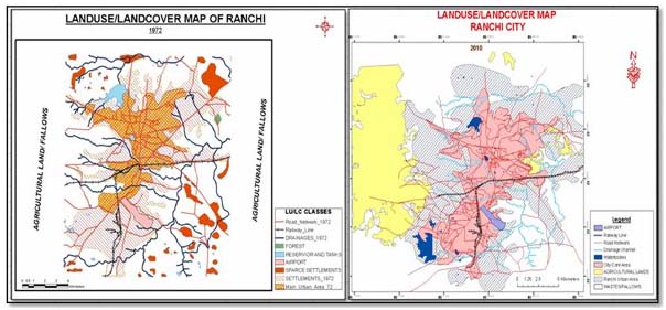
Patterns of spatial and temporal urban changes have been analysed efficiently using spatial and temporal technologies such as Geographical Information Systems (GIS) and Remote Sensing (RS) along with collateral data such as Survey of India (SOI) maps, etc.

In order to study the change of spatial extent of growth and infrastructural facilities, SOI toposheet number 73 E/7 along with IRS PAN with a resolution of 2.5m, LISS-III and LANDSAT-TM was used to generate different layers of years 1972, 2004, 2006 and 2010 respectively. The census of the city was integrated with the above mentioned data to identify the elements at risk associated with different forms of urban hazards.
These were supplemented with collateral information and ground surveys. The basic RS techniques followed were the image pre-processing, processing and interpretation and analysis using the software like ERDAS IMAGINE 8.6 version, Arc GIS 9.2 Version and Arcview GIS 3.2 Version. Finally all the data were integrated in the GIS software to generate the different series of maps and charts to understand the various parameters of urbanisation of the city. An attempt has also been made to suggest a model plan for the future development of the study-area.
The study clearly exhibited that the spatial extent of the city had undergone changes in terms of a haphazard and unorganised growth over the last few decades. It concludes the following –
- According to the study the area has from 1960s onwards suffered from substantial decrease of agricultural lands, open spaces, water bodies, along with an increase of settlements.
- Evidences indicate that urban sprawl in study area followed the oriental pattern and encompassed several unfriendly socio-eco-environmental condition.
- Efforts should be made to generate ample employment, infrastructural and institutional amenities and curb the increasing in-migration of people.
- Moreover, efforts should be drawn to delineate the sprawl boundary of the city up to year 2025, and the planning and developmental actions should be taken up accordingly.
- It is also necessary to draft a taxation policy in which the new inhabitants of the city should be equally accountable to share the burden of extra expenditures for building up the additional facilities like sewerage, roads and so on.
- Furthermore, efforts should be drawn to preserve and protect the present environment and accept a sustainable way of development.
The report can be viewed at Geospatial World here
/articles/impact-assessment-urbanization-indian-city-ranchi-report-geospatial-world