/topics/surface-water
Surface Water
Water quality status of rivers Tungabhadra, Cauvery and Kabini - KSPCB (2007)
Posted on 12 Jun, 2010 01:36 PMThese two documents from the KSPCB website, provide monthly water quality status data, for the rivers Tungabhadra, Cauvery and Kabini, monitored between January to June 2007, at various points along the rivers.
The data recorded are Temperature, pH, Dissolved Oxygen (DO), Biochemical Oxygen Demand (BOD), Chemical Oxygen Demand (COD) and Faecal Coliform.
Draft of “The Dam Safety Bill, 2010” approved
Posted on 08 Jun, 2010 06:24 PMAs per the Press Information Bureau's press release, the Union Cabinet has approved the proposal of the Ministry of Water Resources for enacting The Dam Safety Bill, on May 13 2010. The Bill is to be introduced in the Parliament.
The main objectives of the legislation are:-
• The new legislation will help the States in adopting uniform dam safety procedures which shall ensure safety of dams and safeguard benefits from such dams.
Dams on Himalayan rivers: How good is the science?
Posted on 08 Jun, 2010 05:38 PMThis brief article by Prof Jayanta Bandyopadhyay in the May 16-31 2010 issue of Business Economics magazine, highlights the recent plans of the central and state goverments of constructing a large number of dams on Himalayan rivers. Environmentalists continue to consistently argue against the construction of dams that are built without respect for ecological sciences and warn that this could lead to increase in disasters in the fragile Himalayan region.
Livelihoods magazine special issue on watersheds
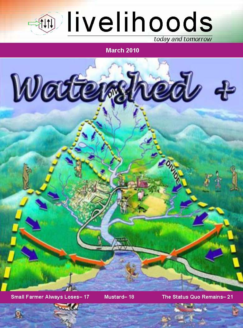
Posted on 07 Jun, 2010 08:14 AM A special issue of the Livelihoods magazine (March 2010) brought out by the Akshara Network for Development Support Services, on Watersheds+.
Increasing productivity of dry lands is possible through soil and moisture conservation (SMC) efforts results in growth led by increases in the farm output. Separate efforts are required to include the land-less and the vulnerable in this growth, so that they also realize the benefits of improved food security, increased employment and diversification of livelihoods. Such activities are known as ‘Watershed Plus’ interventions, and ‘livelihoods’ explores these activities.
Vembanad Fish Count - Report of the Participatory Fish Resources Surveys of Vembanad Lake (Kerala) done in 2008 and 2009 by ATREE
Posted on 03 Jun, 2010 06:23 PM The Vembanad estuarine system, the largest of its kind on the west coast of India is known to be abundantly enriched with diverse fishery resources, providing feeding, spawning and rearing areas for a very large proportion of commercial (fin) fish and shellfish. However, ecosystem health of the Vembanad wetlands is alarmingly declining due to a variety of reasons - obstruction of river courses, sand mining & habitat destruction, loss of riparian canopy cover, encroachment, pollution and unethical fishing practices. Reduced summer flow due to drying up of rivers and pollution hazards from agro-chemicals and sewage also lead to mass mortality of fishes. Depletion of fishery resources has changed this ‘inland fish basket’ to an ‘inland wastebasket’, driving the fisherfolk, the primary stakeholders of the lake into a livelihood crisis.
Channel network delineation and catchment area demarcation of ponds: A GIS-based application
Posted on 25 May, 2010 03:06 PMContent Courtesy: GIS Development
Forwarded to the portal by: Sangeeta Deogawanka
Ponds are important sources of fresh water in the world as they store surface runoff produced by the storms. In this research paper, demarcation of the portion of land contributing runoff to ponds in village Nandgaon (Uttar Pradesh) has been done using topographical information of the surrounding area of the ponds, in a GIS interface.
Awards ceremony of the "Lost lakes of Bangalore" video contest
Posted on 25 May, 2010 01:30 PMAwards distributed to the winners of Lost lakes of Bangalore – A video contest
The awards ceremony of the Lost lakes of Bangalore video contest was held on July 3, 2010 at the TERI auditorium, Domlur.
The contest had two categories of entries – general (aimed at citizens) and the student category.
The Lost lakes of Bangalore contest elicited 23 student category and 15 general category videos, covering 32 lakes of the city.
The awards ceremony was well attended by students, participants and several citizens of Bangalore. Ms. Rohini Nilekani, Chairperson, Arghyamreinvigorated the youth to participate in redefining our lifestyles in order to reach sustainable consumption patterns.
Holistic Engineering and Hydro-Diplomacy in the Ganges-Brahmaputra-Meghna Basin - EPW Paper
Posted on 23 May, 2010 04:49 PM This document by Jayanta Bandyopadhyay, highlights the importance of the Ganges-Brahmaputra-Meghna (GBM) basin as an important source of water for many of the countries in South Asia, and the crucial role of negotiations in the context of the impending water crisis threatening the basin with the phenomenon of climate change.
The document argues that traditional water engineering has been found to be highly reductionistic and ineffective in bringing about development in the GBM basin and the continuing poverty in the GBM basin can be linked to the absence of a holistic ecological perspective, use of an incomplete framework for economics and ignoring of long-run economic costs of the actions proposed.
Letter to Prime Minister on Narmada Dams
Posted on 12 May, 2010 10:48 AMArticle Courtesy: Association for India's Development
Honorable Prime Minister Dr. Manmohan Singh,
We, the undersigned, are writing this letter to ensure that the farmers and tribals displaced by the Sardar Sarovar and Maheswar dams are satisfactorly resettled and rehabilitated and that there is full compliance with environmental safeguards, before any permission is given for further construction work on these dams.
We deeply appreciate the fact that the Central Government has recently ordered suspension of work on the Maheshwar dam since the oustees are not resettled and rehabilitated, as per the requirements of the environmental clearance dated 01.05.2001. While over 80% of the construction work of the Maheshwar dam has been completed a mere 5% of the 70,000 oustees have been rehabilitated.
On variability of hydrological wet season, seasonal rainfall and rainwater potential of river basins in India (using rainfall data over 1813-2006) - An IITM technical paper
Posted on 10 May, 2010 09:12 PMThe paper discuses climatological and fluctuation features of important parameters of the Hydrological Wet Season (HWS), viz. starting and ending dates, duration, seasonal rainfall/rainwater and surplus rainfall/rainwater potential individually for the eleven major and thirty six minor river basins, the West Coast Drainage System (WCDS) and the rest of the country. It is based on reliable monthly rainfall data from a well spread network of three hundred and sixteen rain gauge stations from 1813 upto 2006.
The paper observes that the average period of the HWS is in close conformity with the southwest Monsoonal Rainy Season (MRS) over the basins in the Core Monsoon Rainfall Regime (CMRR). In the Mixed Monsoon Rainfall Regime (MMRR) covering south peninsula, northeast and extreme north, the HWS is of longer duration compared to the MRS due to extra-monsoonal rainfall over there. The mean starting date of the HWS is May 30, ending October 11 and the duration is 135 days for the entire country.


