/topics/surface-water
Surface Water
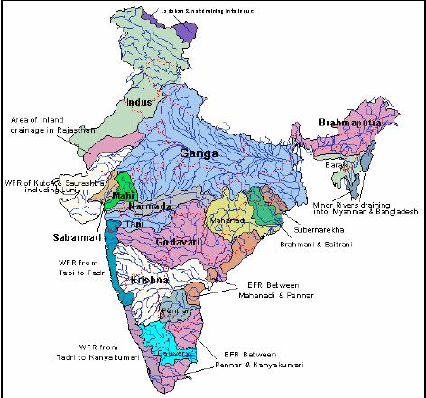
Data on river basins, water pollution, water quality, projects and financing from ministry of water resources
Posted on 01 Jun, 2009 04:34 PMWebsite of Ministry of Water Resources, Govt. of India. contains summary or data on river basins, water resources, water pollution, water quality, projects and financing etc.
Cyclone Aila 2009
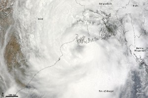
Posted on 01 Jun, 2009 11:27 AMTropical Storm Aila struck southern Bangladesh and eastern India on May 27, 2009. The New York Times reported that floods and mudslides killed at least 191 people and left hundreds of thousands more homeless. As of May 27, the death toll was expected to rise. Images from The Nasa Earth Observatory.
The Moderate Resolution Imaging Spectroradiometer (MODIS) on NASA's Terra satellite captured this true-color image of Aila on May 25, 2009, the same day that the storm temporarily strengthened to a Category 1 cyclone. Aila almost completely fills this scene, stretching from the Bay of Bengal deep into India, Bangladesh, and Burma (Myanmar). On May 25, Aila's wind speeds ranged from 74 kilometers per hour (46 miles per hour or 40 knots) to 120 kilometers per hour (75 miles per hour or 65 knots). More information and detailed images can be accessed here:Cyclone Aila
Andhra Pradesh water, land and trees act (2002)
Posted on 30 May, 2009 10:03 AMThe Andhra Pradesh Water, Land and Trees Act, 2002 repealed the APWALTA Ordinance as well as the AP Ground Water (Regulation for Drinking Water Purposes) Act, 1996. Under this Act an Authority has been constituted at the State, District and Mandal level and administrators for the same were to be appointed.
The modalities for the same appointment of the administrator, terms of office of the nominated members, resignation, removal from authority, allowances, constitution of the District and Mandal authority, meetings of the State, District and Mandal authorities have been worked out.
The river boards act (1956)
Posted on 30 May, 2009 09:15 AMThe act to provide for the establishment of River Boards for the regulation and development of inter-state rivers and river valleys empowers the Central Government, on a request received in this behalf from a State Government or otherwise, by notification in the Official Gazette, to establish a River Board for advising the Governments interested in relation to such matters concerning the regulation or development of an inter-State river or river valley or any specified part thereof.
The inter-state water disputes act (1956)
Posted on 30 May, 2009 09:11 AMIf it appears to the Government of any State that a water dispute with the Government of another State has arisen or is likely to arise by reason of the fact that the interests of the State, or of any of the inhabitants thereof, in the waters of an inter-State river or river valley have been, or are likely to be, affected prejudicially it can request the Central Government under Section 3 of the Act to refer the water dispute to a Tribunal for adjudication.
Effect of climate change on water resources - a preliminary consolidated report by Central Water Commission and the National Institute of Hydrology
Posted on 28 May, 2009 01:12 PM This report on the Effect of Climate Change on Water Resources, prepared by the Central Water Commission and the National Institute of Hydrology, under the guidance of the Ministry of Water Resources in 2008, is one of the first official reports made available by the Government of India, of a reliable quantitative assessment based on field data, of the likely effect of climate change on the availability of water resources, i.e. on the glaciers and snow melt, on rainfall and their effect on run off into the river system and their contribution to ground water.
Use of GIS-based software for hydrological and water allocation modeling - Malaprabha river basin - Karnataka - Technical briefs from the India-PES collaborative project
Posted on 28 May, 2009 12:28 PMThe India-PES initiative, was a collaborative effort undertaken on a pilot basis, by CISED and NIVA, for the development of integrated tools and consulting s
Hydrology and water allocation in Malaprabha - comprehensive database and integrated hydro economic model for selected water services in the Malaprabha river basin
Posted on 28 May, 2009 10:26 AM This study by CISED and NIVA aimed at the development of a comprehensive database on the status of water sector and the development of integrated hydro economic model for selected water services in the study area of the Malaprabha basin. The study focused on exploring the feasibility of Payment for Watershed Services (PWS) to improve the water availability through a detailed analysis of the historic hydrologic data and development of a framework of hydrologic and water allocation model. A hydro-allocation model was developed using the software - ArcView SWAT (AVSWAT) and MIKE-BASIN models.
Integrated river basin modeling framework to support payments for watershed services by Norwegian Institute for Water Research (NIVA)
Posted on 28 May, 2009 10:07 AMThis report by NIVA and CISED has been prepared as part of the India-PES initiative, which was a collaborative effort undertaken on a pilot basis, by CISED and NIVA, for the development of integrated tools and consulting services for Watershed Management and 'Payments for Environmental Services' (PES) in India. Tools and methodologies developed as part of this initiative were tested in the Malaprabha river basin in the state of Karnataka, and the PES implementation was focussed on Participatory Irrigation Management.
Wake up call on reservoir siltation nationwide
Posted on 28 May, 2009 09:30 AM"Wake up call on reservoir siltation nationwide", is a note by Himanshu Thakkar & Swarup Bhattacharyya, written in October 2006, on how storage capacities of the reservoirs have been dropping at an alarming rate, and how little is being to done to stop the wastage.


