/regions/west-bengal
West Bengal
Map depicting the salinity affected areas in India
Posted on 18 Aug, 2009 12:52 PMThe map shows that Tamil Nadu, Kerala, Karnataka, Goa, Maharashtra and Gujarat are high salinity zones, and Andhra Pradesh, Orissa and West Bengal are moderate salinity zones.
Click here to view the map - IRFC
Central Ground Water Board's hydrogeological survey of West Bengal
Posted on 12 Aug, 2009 01:26 PM
Courtesy: CGWB
The status of water resources in West Bengal: A report by Kalyan Rudra
Posted on 12 Aug, 2009 12:58 PMThe availability of water, water requirement versus supply, water requirements for some major crops, groundwater exploitation, growth of population, and declining per capita water in the state of West Bengal are presented.
Groundwater information booklet of arsenic affected Murshidabad district of West Bengal
Posted on 12 Aug, 2009 11:32 AMThe groundwater related issues and problems the distrcit include:
Groundwater Arsenic Contamination In Middle Ganga Plain
Posted on 11 Aug, 2009 03:32 PMThe School of Environmental Studies of Jadavpur University has studied the arsenic contamination for the last 19 years. Their website gives some of the details of their work -
Jadavpur university, Kolkata, presents water management system for a hostel block in the university
Posted on 22 Jul, 2009 01:29 PMIn this presentation Probhash Kumar Biswas and Tirthankar Sarkar of Jadavpur University, Kolkata have designed a rainwater harvesting and grey water recycling system to meet some of the water needs of the hostel block in Jadavpur University.
Groundwater Arsenic Contamination in the Ganga-Padma-Meghna-Brahmaputra Plain of India and Bangladesh
Posted on 01 Jun, 2009 04:20 PMGroundwater Arsenic Contamination in the Ganga-Padma-Meghna-Brahmaputra Plain of India and Bangladesh.This report from the Jadhavpur University highlights the intensity and magnitude of the arsenic contamination in the Ganga-Meghna-Bramhaputra plain which includes states Uttar Pradesh, Bihar, Jharkhand, West Bengal and Assam covering an area of 569,749 sq km.
The West Bengal ground water resources management, control and regulation act (2005)
Posted on 01 Jun, 2009 03:55 PMThe act aims to manage, control and regulate indiscriminate extraction of groundwater in West Bengal and to provide against its widespread contamination with arsenic, fluoride, chloride, iron, other heavy metals or metalloids, organic and inorganic pesticides, fungicides, and rodenticides. It provides for the setting up of a State Level Authority which shall be under the administrative control of the Water Investigation and Development Department, Government of West Bengal and shall be the apex body of all the District Level Authorities and the Corporation Level Authority.
District human development report card for 10 districts- the PAHELI report
Posted on 01 Jun, 2009 03:46 PMThe PAHELI report (Peoples' Audit of Health Education and Livelihoods) is a rapid assessment of the prevailing status of human development in a district and covers four major sectors: life and livelihoods, water and sanitation, mother and child health, and education and literacy. The design and execution of PAHELI was done by Pratham and PAHELI district partners.
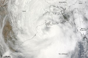
Cyclone Aila 2009
Posted on 01 Jun, 2009 11:27 AMTropical Storm Aila struck southern Bangladesh and eastern India on May 27, 2009. The New York Times reported that floods and mudslides killed at least 191 people and left hundreds of thousands more homeless. As of May 27, the death toll was expected to rise. Images from The Nasa Earth Observatory.
The Moderate Resolution Imaging Spectroradiometer (MODIS) on NASA's Terra satellite captured this true-color image of Aila on May 25, 2009, the same day that the storm temporarily strengthened to a Category 1 cyclone. Aila almost completely fills this scene, stretching from the Bay of Bengal deep into India, Bangladesh, and Burma (Myanmar). On May 25, Aila's wind speeds ranged from 74 kilometers per hour (46 miles per hour or 40 knots) to 120 kilometers per hour (75 miles per hour or 65 knots). More information and detailed images can be accessed here:Cyclone Aila
