Term Path Alias
/topics/rivers
/topics/rivers

The report deals with the estimation of geomorphology parameters for small catchments using Geographical Information Systems (GIS). Stream channel morphology is literally the study of stream channel form and structure, but generally it is taken to mean their form and structures regarded as a whole or their collective morphology features. Systematic analysis of morphometry of any drainage basin and its stream system is of great importance in understanding the hydrological behavior of the basin.
In this report an attempt has been made to estimate the mean monthly reference crop evapotranspiration (ETo) for the Krishnai Irrigation Project in Assam. To undertake this analysis, the mean monthly climatological and physiographical data for the period of 1986 to 1994 has been collected from the Meteorological Department, Borjhar, Assam.
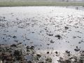
The study deals with the distribution of heavy metals on sediments under different flow conditions in the river Hindon. The river is subjected to varying degree of pollution caused by numerous untreated waste outfalls of municipal and industrial effluents.
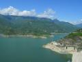
The report presents an inventory of water bodies in the State of Jammu & Kashmir in the Western Himalayan region prepared using satellite data of IRS-1A (standard FCC, scale 1:250000) for 1988/ 99 and digital data of IRS-1C for 1998. Also, presented is a database developed with the help of Survey of India (SoI) topographic maps, which includes name and type of the water body, nearest place, district, river basin, geographical coordinates and elevation.
In this study, the mathematical model developed at the National Institute of Hydrology for estimation of the Clark model parameters using the geomorphological characteristics of an ungauged basin has been applied for simulation of the direct surface runoff (DSRO) hydrographs of the Ajay basin up to the Sarath gauging site of South Bihar.
The Soil Conservation Services Curve Number (SCS-CN) method presented in this report has been applied to two large catchments in sub-humid regions of India and its performance evaluated. The variation of the curve number is examined and discussed and a critical evaluation of the employment of the single linear reservoir routing technique and linear regression technique presented.
The report, a part of the regular work programme of the Flood Studies Division of the National Institute of Hydrology presents a literature review on modeling debris flow. Occurrence of debris flows is a common natural phenomenon and denotes the rapid flow of debris with sufficient water to disperse grains uniformly throughout the entire depth. Dam break flows, landslides and flows in a mountainous terrain are some of the examples.
In this study, an attempt has been made to develop a regional flood formula using L-moments for the north Brahmaputra river system. The annual maximum peak flood data of twelve gauging sites of the north bank tributaries of the river have been considered. The screening of the data has been carried out for assessing the suitability of the data for regional flood frequency analysis by computing the Discordancy Measure (Di) in terms of L-moments. Also, homogeneity of the region has been tested using the L-moment based heterogeneity measure, H.
The study evaluates the applicability of Artificial Neural Networks (ANN) in rainfall-runoff process modeling for the Ajay river basin, Jharkhand to predict the 6-hour ahead runoff at Sarath. Initially three flood events were considered for training, to find out the weights between different layers of the network. The back propagation algorithm has been used for optimization of weights. The developed ANN was validated for rest of the flood events.
In the present study, two different Artificial Neural Networks (ANN) were developed for Dharoi reservoir, Gujarat, one for flood control operation and another for conservation operation. In recent years, ANNs are increasingly being used to predict water resources variables particularly in the operation of reservoirs, the most important elements of complex water resources systems, constructed for spatial and temporal distribution of water.