Rainfall and other forms of Precipitation

Term Path Alias

/topics/rainfall-and-other-forms-precipitation

Featured Articles
May 8, 2024 What is the ecosystem based approach to water management? How can it help in solving the water woes of states in the Deccan Plateau?
An ecosystem based approach to water management (Image Source: India Water Portal)
January 25, 2024 This report by CEEW discusses the findings of a study on India’s first sub-district -level monsoon variability assessment to decode changing rainfall patterns across India during the southwest and northeast monsoon.
The moody monsoon (Image Source: Mayank Makhija via IWP Flickr photos)
August 16, 2023 India Water Portal is hosting a photo competition on World Photography Day. Hurry, send us your photos before 31st August!
May 8, 2023 Warming will not only lead to a decline, but also trigger monsoon extremes in the Indo Gangetic Plains.
A woman wades through knee-deep water with her belongings. (Picture courtesy - 101Reporters) (Source: IWP Flickr photos)
May 4, 2023 Climate change is expected to have significant impacts on the Indian monsoon
As per the India Meteorological Department (IMD), instances of heavy rainfall have increased by almost 85% in the country since 2012 (Image: Marina, 2009,Wikimedia Commons)
April 4, 2023 Forests greatly help in maintaining the water balance of nature by storing water during monsoons and making this water available during dry seasons. India urgently needs to save its forests to prevent droughts and the adverse effects of climate induced global warming.
Forests and soil moisture can act as buffers to store water during dry spells (Image Source: India Water Portal)
GIS mapping of wetlands: Strengthening indigenous peoples response to multiple-use water services (MUS)
The project 'Strengthening indigenous people’s response to multiple-use water services', supported by ARGHYAM takes people’s multiple water needs as the starting point in identifying opportunities within the water limitations & changing environment, in planning and design of existing cropping and water resource systems for up-gradation. Posted on 05 Mar, 2012 11:04 AM

Article Courtesy : Resources Centre for Sustainable Development

The interactive GIS mapping of wetlands and MUS intervention sites is one of the outputs of the project. 

Interactive layers are present on the left panel of the pdf file.

Climate variability and change in the Himalayas: Community perceptions and responses - An ICIMOD study
This document by the International Centre for Integrated Mountain Development (ICIMOD) presents the findings of a study that was designed to investigate the impact of climate and socioeconomic change on the vulnerability and livelihoods of mountain people and their coping and adaptation strategies. ICIMOD conducted a community-based vulnerability and adaptive capacity assessment in four different areas that included Uttarakhand in northwestern India (two districts), Nepal (two districts), Eastern Bhutan (two districts), and North East India (one district in Assam and one in Meghalaya). The overall aim was to contribute to enhancing the resilience of vulnerable mountain communities in the Hindu-Kush Himalayan (HKH) region to change. Posted on 22 Feb, 2012 05:30 PM

The general objectives of the assessments were:

The status of glaciers in the Hindu Kush-Himalayan region - A report by the ICIMOD
This study by ICIMOD provides a comprehensive account of the number and status of glaciers across the Hindu Kush-Himalayan region. Posted on 17 Feb, 2012 03:00 PM

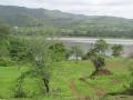
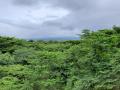
The HKH region is one of the most dynamic, fragile, and complex mountain systems in the world as a result of tectonic activity and the rich diversity of climates, hydrology, and ecology. The high Himalayan region is the freshwater tower of South Asia and has the highest concentration of snow and glaciers outside the polar regions giving it the name Third Pole.

Balati glacier at sunset

Balati glacier, Pithoragarh district, Uttarakhand (Source: Uttarakhand and I)

Climate change in the Hindu Kush-Himalayas -The state of current knowledge - A book by ICIMOD
This book by ICIMOD presents an analyses of the available data on climate change in the Hindu Kush-Himalayan region, and identifies persisting insufficiencies in the data. Posted on 16 Feb, 2012 01:10 PM

The Hindu Kush-Himalayan region has had very few resources to develop a detail scientific understanding needed to assess climatological, environmental, and other data in the past and there is very little information upon which a baseline for comparison with the present can be formed and future impacts can be anticipated.

Climate: Observations, projections and impacts - India - A report by the Met Office (UK)
This report by the Met Office, UK describes the findings of a study that aimed at compiling observations, projections and impacts of climate change in the context of India Posted on 15 Feb, 2012 03:25 PM

This was done as a part of a project that aimed at compiling scientifically robust and impartial information on the physical impacts of climate change for more than 20 countries.

Adaptation to climate change with a focus on rural areas and India - A document by GTZ (India)
This document is an outcome of ongoing project by GTZ and MoEF to devise ways of dealing with the inevitable impacts of climate change. Posted on 15 Feb, 2012 01:59 PM

It aims to strengthen the capacities of rural communities in India to live with climate variability and change. The work includes supporting governments of four partner states of Rajasthan, Tamil Nadu, Madhya Pradesh and West Bengal, local communities and other relevant stakeholders in identifying, developing and carrying out adaptation measures in pilot regions.

Cold wave in North India claims several lives, disrupting normal conditions, heavy snowfall in Himachal Pradesh and Kashmir
Chicu presents an update on floods, disasters, extreme weather events (1 to 15 January 2012). Posted on 17 Jan, 2012 09:12 AM

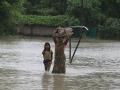
A western disturbance caused a cold wave to sweep across the northern part of the country, claiming several lives and disrupting normal conditions. Reports of water pipes freezing, roads becoming unmotorable have come in from several parts of the country. This might affect crops this winter. 

satellite map of India showing the western disturbance

Examining the storm protection services of mangroves of Orissa during the 1999 cyclone – A special article in EPW
Mangroves are tropical and subtropical coastal forests that grow in inter-tidal saline areas and estuary mouths between the land and the sea. Posted on 06 Jan, 2012 11:03 PM

These ecosystems provide a bunch of direct and indirect services to humankind. This special article in Economic and Political Weekly (EPW) by Saudamini Das examines whether the mangrove forests in Kendrapada district of Orissa played any protective role during the severe cyclone that hit the state in October 1999. 

Cyclone Thane hits landfall between Puducherry and Cuddalore districts in Tamil Nadu, Heavy rainfall expected over Kerala in the next 24 hours - An update on floods, disasters, extreme weather events (1 to 31 December 2011)
The news for the month of December 2011 is presented below - Posted on 01 Jan, 2012 04:50 PM

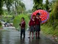
It has been dominated by reports of  a major cyclone Thane that lay centered on the the 29th December 2011 near latitude 12.30N and longitude 83.00E, about 300 km east-southeast of Chennai (Tamilnadu) and 480 km north-northeast of Trincomalee (Sri Lanka). Earlier reports related to the cyclone Thane indicate predictions and cyclone warnings made by the IMD for the north of Tamil Nadu and the south Andhra Pradesh coast along with possibility of heavy rains and severe winds and warnings for fishermen to refrain from going into the sea.

Later reports indicate that Cyclone Thane has hit the landfall between the Union territory of Puducherry and neighbouring Cuddalore district in Tamil Nadu at about 9 am leaving behind a trail of devastation followed by later reports of weakening of the cyclone activity and predictions of heavy rainfall over Kerala, south interior Karnataka and north interior Tamil Nadu

The impacts of water infrastructure and climate change on the hydrology of the Upper Ganges river basin – A research report by IWMI
This study by International Water Management Institute (IWMI) assessed the variability of flows under present and ‘naturalized’ basin conditions in the Upper Ganges Basin. Posted on 18 Dec, 2011 07:03 PM

GangaThe Ganges river system originates in the Central Himalayas, and extends into the alluvial Gangetic Plains and drains into the Indian Ocean at the Bay of Bengal. In the upstream mountainous regions, hydropower is the main focus of development with mega and micro projects either under construction or being planned in both Nepal and India.

After the main river channel reaches the plains, it is highly regulated with dams, barrages and associated irrigation canals. All this infrastructure development and abstractions affects the river’s flow regime and reduces flows, which, in turn, impacts downstream water availability, water quality and riverine ecosystems. Furthermore, there are concerns that climate change is likely to exacerbate the water scarcity problem in the Ganges Basin. Therefore, modeling the hydrology of the basin is critical for estimation, planning and management of current and future water resources.