Vladimir Smakhtin
Vladimir Smakhtin
Study reveals Indian dams to lose 26% water storage capacity by 2050
Posted on 08 Feb, 2023 05:13 PMReservoir sedimentation is often seen as a site-specific process and is usually assessed at an individual reservoir level. At the same time, it takes place everywhere in the world. However, estimates of storage losses globally are largely lacking.
Assessment of the environmental flows requirements for the Upper Ganga basin: A report by the World Wide Fund for Nature (India)
Posted on 22 Jun, 2012 02:27 PMThe Ganga is the most sacred river in the sub-continent, and revered by millions.It is also among the top ten rivers at risk. The key threat to the river is indiscriminate abstraction of water from the river, leavng it unable to maintain its ecological integrity or to satisfy the needs of riparian communities.
The impacts of water infrastructure and climate change on the hydrology of the Upper Ganges river basin – A research report by IWMI
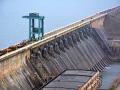
Posted on 18 Dec, 2011 07:03 PM The Ganges river system originates in the Central Himalayas, and extends into the alluvial Gangetic Plains and drains into the Indian Ocean at the Bay of Bengal. In the upstream mountainous regions, hydropower is the main focus of development with mega and micro projects either under construction or being planned in both Nepal and India.
After the main river channel reaches the plains, it is highly regulated with dams, barrages and associated irrigation canals. All this infrastructure development and abstractions affects the river’s flow regime and reduces flows, which, in turn, impacts downstream water availability, water quality and riverine ecosystems. Furthermore, there are concerns that climate change is likely to exacerbate the water scarcity problem in the Ganges Basin. Therefore, modeling the hydrology of the basin is critical for estimation, planning and management of current and future water resources.
Mapping drought patterns and impacts: A global perspective – A research report by IWMI
Posted on 26 Oct, 2011 08:11 PMThis study by the International Water Management Institute (IWMI) examines the global patterns and impacts of droughts through the mapping of several drought-related characteristics – either at a country level or at regular grid scales. Characteristics cover various aspects of droughts – from global distribution of meteorological and hydrological drought risks to social vulnerability and indices related to water infrastructure.