/topics/droughts-and-floods
Droughts and Floods
Information on droughts and floods in India by ministry of water resources
Posted on 01 Jun, 2009 04:24 PMFloods: In India, out of the total geographical area of 329 m ha., the flood prone area has been estimated as 45.64 m.ha. Heavy flood damages were experienced in the country during the monsoon of 1955, 1971, 1973, 1977, 1978, 1980, 1984, 1988, 1989, 1998, 2001 & 2004.
Cyclone Aila 2009
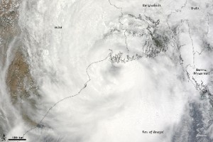
Posted on 01 Jun, 2009 11:27 AMTropical Storm Aila struck southern Bangladesh and eastern India on May 27, 2009. The New York Times reported that floods and mudslides killed at least 191 people and left hundreds of thousands more homeless. As of May 27, the death toll was expected to rise. Images from The Nasa Earth Observatory.
The Moderate Resolution Imaging Spectroradiometer (MODIS) on NASA's Terra satellite captured this true-color image of Aila on May 25, 2009, the same day that the storm temporarily strengthened to a Category 1 cyclone. Aila almost completely fills this scene, stretching from the Bay of Bengal deep into India, Bangladesh, and Burma (Myanmar). On May 25, Aila's wind speeds ranged from 74 kilometers per hour (46 miles per hour or 40 knots) to 120 kilometers per hour (75 miles per hour or 65 knots). More information and detailed images can be accessed here:Cyclone Aila
To adapt or not to adapt - the dilemma between long term resource management and short term livelihoods
Posted on 20 May, 2009 10:15 AMThis chapter from the book 'The Agricultural Groundwater Revolution: opportunities a
Poverty eradication by Neeru-Meeru, an initiative undertaken by government of Andhra Pradesh
Posted on 19 May, 2009 05:55 PMThis report by the Panchayati Raj and Rural Development Department, Government of Andhra Pradesh, provides information on Neeru Meeru, a water conservation and poverty alleviation inititaive undertaken by the governemnt of Andhra Pradesh.
Annual flood misery in north Bihar - presentations by Megh Pyne Abhiyaan
Posted on 12 May, 2009 04:30 PM These three sets of presentation by Eklavya Prasad, Practitioner, Natural and Social Resource Management have been summarized below -
Bihar’s flood survival mechanisms
Waternama - a collection of traditional practices of water conservation and harvesting in Karnataka
Posted on 08 May, 2009 05:16 PMWaternama is a collection of traditional practices for water conservation and management in Karnataka. The book is produced by Communication for Development and Learning and edited by Sandhya Iyengar.
View/download the full book (29.2 MB)
NASA Earth Observatory: Cyclone Bijli
Posted on 07 May, 2009 12:03 PMImage & Content Courtesy: NASA Earth Observatory
 A ragged-looking Tropical Storm Bijli draped the east coast of India in this image from the Moderate Resolution Imaging Spectroradiometer (MODIS) on NASA's Terra satellite on April 16, 2009. Bijli became a tropical storm in the northwest Bay of Bengal on April 15, and initially headed north, toward the west coast of India. By April 16, it had begun a northeastward turn, however, and the storm was being projected to make landfall in eastern Bangladesh on April 17, according to Unisys. Access higher resolution image here:Cyclone Bijli
The Sambalpur declaration on Odisha rivers : Let the river flow
Posted on 23 Apr, 2009 12:04 PMWater Initiatives Orissa(WIO) and the Indian River Network (IRN) organsied the Odisha River Conference during 18 - 20 April 2009 at Sambalpur, Odisha. Attended by about 75 participants which included activists, environmentalists, journalists, academicians, researchers and civil society representatives from across the country, the Conference has just concluded with a "Sambalpur Declaration" that calls for saving the rivers from the current fate of high rate of degradation and giving communities their traditional rights over the rivers, among other strong resolutions.
Kosi Katha - The making of a famine': Video highlighting the growing famine in the wake of the floods in Bihar
Posted on 14 Apr, 2009 04:05 AM
The latest loss figures (24 Feb. 09 is five districts, 35 blocks, 33.29 lakh peopla, 9.97 lakh live stock., affected area 3.68 lakh hectares, 2.37 lakh houses, 527 human death a and 19,323 loss of cattle.
Kosi darshan: A deeper look at the lives of those pinned on the river
Posted on 31 Mar, 2009 05:14 PM"If it had not breached at Kusaha, it would have anyway breached at this point," points a villager towards the probable location on the eastern bank in village Rajabaas near Prakashpur in Sunsari district of Nepal, located 14 km upstream of Kusaha where the Eastern Afflux embankment of the Kosi had breached on the August 18, 2008.


