Term Path Alias
/sub-categories/maps
/sub-categories/maps


Basin indicators map of Narmada river basin

Basin indicators map of Godavari river basin
Ganga river basin

Basin indicators map of Tapti river basin
Water flows without regard to political and administrative boundaries. Water planning with respect to rivers should therefore be done for the river basin (or sub-basin) as a whole. River basin planning also has to look in an integrated way at all the relevant parameters like urban and rural populations, water usage patterns, water pollution, wastewater flows.
Culture and places of historical significance
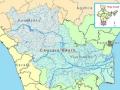
The river Cauvery has been the inspiration for various civilizations who have thrived on the banks of the river. This can be seen manifested in the various forms of art, culture and philosophy that have originated along the course of the river.
Forwarded to the Portal by: Anuradha ![]() The United Nations Educational, Scientific and Cultural Organization (UNESCO) will publish the first-ever world map of underground aquifers, which account for some 96 per cent of global freshwater resources, the agency announced in a press release today. Despite their strategic importance, no global inventory of aquifers , most of which straddle international boundaries , had been compiled before UNESCO started work on its online map, which will be launched to coincide with the submission to the General Assembly of a draft Convention on Transboundary Aquifers next week. The UNESCO is presenting a detailed map identifying underground water resources that are shared by at least two countries, using data compiled since 2000 by UNESCO's International Hydrological Programme for a groundwater database. The map will include information about the quality of water and rate of replenishment of the 273 transboundary aquifers , 68 in the American continent, 38 in Africa, 65 in Eastern Europe, 90 in Western Europe and 12 in Asia.
The United Nations Educational, Scientific and Cultural Organization (UNESCO) will publish the first-ever world map of underground aquifers, which account for some 96 per cent of global freshwater resources, the agency announced in a press release today. Despite their strategic importance, no global inventory of aquifers , most of which straddle international boundaries , had been compiled before UNESCO started work on its online map, which will be launched to coincide with the submission to the General Assembly of a draft Convention on Transboundary Aquifers next week. The UNESCO is presenting a detailed map identifying underground water resources that are shared by at least two countries, using data compiled since 2000 by UNESCO's International Hydrological Programme for a groundwater database. The map will include information about the quality of water and rate of replenishment of the 273 transboundary aquifers , 68 in the American continent, 38 in Africa, 65 in Eastern Europe, 90 in Western Europe and 12 in Asia.
The NRSA and the Govt of India is working together to provide near real time data on the current flood situation in Bihar by using satellite imagery.