/regions/south-24-parganas-district
South 24 Parganas District
Living through Cyclone Amphan and Covid-19: Climate change and water security
Posted on 07 Jun, 2020 11:33 AMThe nomenclature of cyclones and hurricanes is developed much in advance through multilateral processes in the region. The name Amphan (Sky in Thai and Akash in Bangla) was chosen from a long list of potential disasters long back.

How bio-restoration is helping revive degraded mangroves in Sunderbans
Posted on 17 Sep, 2019 06:06 PMNew Delhi, September 17 (India Science Wire): A new technology developed by Indian scientists for ecological restoration is helping in revival of mangroves degraded due to rising sea levels, climate change and human intrusion in the Sunderbans in West Bengal.

Community effort saves mangroves
Posted on 04 Aug, 2016 09:52 AMCome monsoon, the villages in the Sundarbans islands witness nature’s fury with floodwaters overriding all boundaries and inundating huge tracts of land. As such, the earthen embankments, stretching to 3600 kms on the 54 inhabited islands out of a total of 102 in the Sundarbans, protect scores of people from floods and tidal waves.

India loses 2 million tonnes of food grains annually due to waterlogging
Posted on 30 Jul, 2014 10:15 AM2 million tonnes of food grains lost annually in India

The return of the earthworm: Association for India's Development's (AID-JHU) practicing organic farming in the Sunderbans
Posted on 08 Apr, 2012 10:51 PMArticle and Video Courtesy : Association for India's Development - Johns Hopkins University
Author : Nishikant
Ujaan: Festival for the Sunderbans, 10th to 12th March 2011, Frasergunj-Bakkhali, Sunderban district, West Bengal
Posted on 24 Feb, 2011 11:31 AMOrganizer: Ujaan
Venue: Frasergunj-Bakkhali, Sunderban district, West Bengal
Cyclone Aila 2009
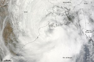
Posted on 01 Jun, 2009 11:27 AMTropical Storm Aila struck southern Bangladesh and eastern India on May 27, 2009. The New York Times reported that floods and mudslides killed at least 191 people and left hundreds of thousands more homeless. As of May 27, the death toll was expected to rise. Images from The Nasa Earth Observatory.
The Moderate Resolution Imaging Spectroradiometer (MODIS) on NASA's Terra satellite captured this true-color image of Aila on May 25, 2009, the same day that the storm temporarily strengthened to a Category 1 cyclone. Aila almost completely fills this scene, stretching from the Bay of Bengal deep into India, Bangladesh, and Burma (Myanmar). On May 25, Aila's wind speeds ranged from 74 kilometers per hour (46 miles per hour or 40 knots) to 120 kilometers per hour (75 miles per hour or 65 knots). More information and detailed images can be accessed here:Cyclone Aila
Nature of arsenic pollutants in groundwater of Bengal basin – A case study from Baruipur area - West Bengal (India)
Posted on 21 May, 2009 04:29 PMThis article published in Current Science discusses the nature of arsenic pollutants in the groundwater of Bengal basin.
