/regions/political
Political
National Symposium on "Sustainable Rice Production System under Changed Climate", ARRW, Cuttack
Posted on 22 Sep, 2010 11:06 AM![]()
Organizers:
TheWater Channel news flash - Video contest
Posted on 22 Sep, 2010 10:34 AM
We are proud to announce the video contest "Water, Climate and.....Action!"
Water, Climate and…..Action! Enter your short film in the contest!
India’s groundwater typologies – A presentation by ACWADAM
Posted on 22 Sep, 2010 08:01 AMThis presentation by ACWADAM deals with groundwater typologies in India. The typology of groundwater can be defined in many ways based on a) Uses of Groundwater, b) Geography, c) Geology, d) Hydrogeology (Aquifers), e) Groundwater Quality, f) Stage of Groundwater Development, and g) Socio-ecology of Groundwater.
Integrated Data Management Systems using Geographic Information Systems – A presentation by ACWADAM
Posted on 21 Sep, 2010 11:25 PMThis presentation by ACWADAM deals with integrated data management using Geographic Information Systems. A Geographic Information System (GIS) integrates hardware, software, and data for capturing, managing, analyzing, and displaying all forms of geographically referenced information.
Chemistry of groundwater – A presentation by ACWADAM
Posted on 21 Sep, 2010 10:40 PMThis presentation by ACWADAM deals with the chemistry of groundwater. It is now recognized that the quality of groundwater is as important as its quantity. All groundwater contains salts in solution which are derived from the location and the movement of water through rocks. The quality of groundwater supply depends where and for what it is planned to be used. Thus water quality standards for drinking water, industrial water and irrigation water differ significantly.
Groundwater balance – A presentation by ACWADAM
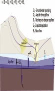
Posted on 21 Sep, 2010 10:00 PM This presentation by ACWADAM deals with the subject of groundwater balance. It begins by describing the skeleton for the water balance equation viz., ground surface, soil, aquifer and bed rock. It describes the processes subsequent to rainfall such as interception, initial detention, depression storage, infiltration, runoff, streamflow, soil moisture retention and recharge.
The watershed water balance equation is explained in terms of input (rainfall and water transfers) and output (runoff, evapotranspiration and infiltration). It notes that the input to a generalized water balance is rainfall whereas the input to a groundwater balance is infiltration. The difference between infiltration & recharge, natural & artificial recharge and interflow & discharge are explained thereafter. The water balance for an aquifer may vary, depending upon the nature of groundwater system –
- Watershed with a deep aquifer
- Watershed has both shallow and deep aquifers
- Watershed has only shallow aquifer
An Invitation to rally in the valley - 25 years of Struggle and Reconstruction in Narmada Valley, Badwani, Madhya Pradesh
Posted on 21 Sep, 2010 05:01 PMForwarded to the Portal by: National Alliance of People's Movements (NAPM)
India Infrastructure Report 2011 on Water - Call for papers
Posted on 21 Sep, 2010 02:22 PM Papers may address one or more of the following areas:
Situation analysis
- Studies assessing current and future water situation in India
- Water – climate change nexus and implications for the future
The deepest cut: Political ecology in the dredging of a new sea mouth in Chilika lake - Orissa (India)
Posted on 21 Sep, 2010 09:19 AMThis paper published in the journal Conservation and Society reassesses/debates the decision taken by the government to dredge a new sea mouth in the Chilika Lake in Orissa, India, which was based on Geographical Information Systems (GIS) studies.
The paper argues that decisions such as these need to be understood and evaluated by taking into consideration not only the underlying technical aspects, but by also exploring the political and historical contexts in which decisions are taken.
Geological mapping – A presentation by ACWADAM
Posted on 21 Sep, 2010 08:27 AMThis presentation by ACWADAM deals with geological mapping. The occurrence of water within a watershed is governed by the rock types occurring both at the surface and within the subsurface, their sequence and their structure. The physical structure which plays host to the water within the watershed is geological. Every watershed programme must therefore include a fundamental understanding of this framework so that the development and management measures planned through such programmes are meaningful and properly justified technically.