Advanced Centre for Water Resources Development and Management (ACWADAM)
Advanced Centre for Water Resources Development and Management (ACWADAM)
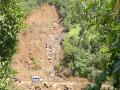
How to be prepared before landslides?
Posted on 19 Jun, 2023 11:10 AMCome monsoons and reports of landslide events start appearing from different parts of India including Maharashtra. Indeed, an exponential rise in the occurrence of landslides and mudslides in Western Maharashtra is being reported in recent years. And these can unleash massive destruction, lead to loss of lives and damage infrastructure and property.
Understanding groundwater - A course by ACWADAM
Posted on 20 Dec, 2010 01:01 AMThe Advanced Centre for Water Resources Development and Management (ACWADAM) has created a power-point course to explain the formation of groundwater and its management.
The course consists of 6 modules; it includes the basics of understanding groundwater, study of geology, groundwater level and movement, planning and management of groundwater, storage and flow of groundwater and water quality. The modules have been made into succinct power-point presentations that include charts, diagrams and photographs besides the written word.
Climate change and its impact on groundwater – A presentation by ACWADAM
Posted on 13 Nov, 2010 09:38 PMThis presentation by ACWADAM deals with climate change and its impacts on long-term replenishment of groundwater. The presentation provides an overview of the current insights and knowledge on climate change impacts and gives an overview of best options for developing and safeguarding groundwater resources.
Case studies on water quality - A presentation by ACWADAM
Posted on 25 Sep, 2010 10:19 AMThis presentation by ACWADAM deals with monitoring of water quality in a watershed. It describes the process of going about conducting a hydrogeological study of the watershed, right from the study of the basic geology to the importance of the quality of groundwater in the watershed. The main hydrogeological provinces of India are described - (a) Hard rock regimes: Crystalline rocks, Volcanic (Deccan basalt), (b) Alluvial regimes, and (c) Consolidated sedimentary regimes: Soft sedimentary, Hard sedimentary.
Aquifers: The hosts of groundwater – A presentation by ACWADAM
Posted on 25 Sep, 2010 08:44 AMThis presentation by ACWADAM on aquifers states that a systematic approach to groundwater studies is required to understand how water exists in each type of rock or sediment for which hydrogeological mapping of aquifers becomes significant in every watershed programme. The necessity of studying the scientific aspects of groundwater such as its properties and distribution below the earth’s surface is highlighted.
The Himalayas – A presentation by ACWADAM
Posted on 24 Sep, 2010 10:38 PMThis presentation by ACWADAM deals with the Himalayan mountain system, the planet's highest, and home to the world's highest peaks. It specifically deals with the various divisions, the kind of structures present and the presence of groundwater in the massive mountain system.
Processes that shape the earth: II – A presentation by ACWADAM
Posted on 24 Sep, 2010 08:14 PMThe presentation deals with weathering, erosion and deposition of rocks -
- The process of breaking down and alteration of rocks and formation of new materials from them is known as weathering of rocks.
- The group of processes whereby the materials of the earth’s crust are moved from one place to another by running water (including rainfall), waves and current, glacier ice and wind is known as erosion.
- The processes whereby the material being carried during the process of erosion is deposited either through physical processes (such as drop in the velocity of flowing water) or precipitation of dissolved material under a set of conditions for instance, the deposition of limestones from water rich in calcium carbonate is known as deposition.
Processes that shape the earth: Part I – A presentation by ACWADAM
Posted on 24 Sep, 2010 07:04 PMThis presentation by ACWADAM on processes that shape the earth attempts to understand the irregularities of the surface of earth so as to consider the movement of groundwater. The earth’s surface is dotted with what is commonly perceived as high grounds or ‘hills’ and the low grounds or ‘valleys’. Hills and valleys result from movements in the earth and the long term processes of breaking-down the earth surface at some places and building it up at others, also called as diastrophism.
Hydrogeology and sanitation guidelines – A presentation by ACWADAM
Posted on 23 Sep, 2010 11:11 PMThis presentation by ACWADAM deals with hydrogeology and sanitation guidelines. Safe water supply and sanitation choices are an important public health measure and source quality improvement is critical to this. The impact of different aspects of water and sanitation appears to be largely dependent on the conditions within a particular community and existing access to other components of water and sanitation.
Groundwater modeling – A presentation by ACWADAM
Posted on 23 Sep, 2010 08:13 PMThis presentation by ACWADAM deals with groundwater modeling using the Water Evaluation and Planning System (WEAP) model. WEAP is a microcomputer tool for integrated water resources planning and operates on the basic principle of a water balance. WEAP is distinguished by its integrated approach to simulating water systems and by its policy orientation. It provides a comprehensive, flexible and user-friendly framework for policy analysis.