/regions/physiography
Physiography
Half full, Half empty: A WaterAid publication on the drought and drinking water crisis in Bundelkhand
Posted on 11 Aug, 2009 01:44 PMThis paper on Bundelkhand from their Water and Sanitation Perspective series of WaterAid presents how ecological degradation and faulty policies make drinking water scarce and less accessible.
Infiltration wells in the Himalayas - Videos by Pan Himalayan Grassroots Development Foundation
Posted on 12 Jun, 2009 09:38 AMThis is a DVD made by a non-profit group that has been uploaded to the web where it could reach many more people and add visibility to your organisation's work. If you would like India Water Portal to do something similiar with your organisation's DVD , please mail us at portal@arghyam.org
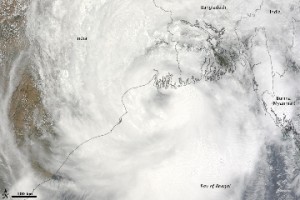
Cyclone Aila 2009
Posted on 01 Jun, 2009 11:27 AMTropical Storm Aila struck southern Bangladesh and eastern India on May 27, 2009. The New York Times reported that floods and mudslides killed at least 191 people and left hundreds of thousands more homeless. As of May 27, the death toll was expected to rise. Images from The Nasa Earth Observatory.
The Moderate Resolution Imaging Spectroradiometer (MODIS) on NASA's Terra satellite captured this true-color image of Aila on May 25, 2009, the same day that the storm temporarily strengthened to a Category 1 cyclone. Aila almost completely fills this scene, stretching from the Bay of Bengal deep into India, Bangladesh, and Burma (Myanmar). On May 25, Aila's wind speeds ranged from 74 kilometers per hour (46 miles per hour or 40 knots) to 120 kilometers per hour (75 miles per hour or 65 knots). More information and detailed images can be accessed here:Cyclone Aila
Water management traditions in the central-western Himalayas : a study by People's Science Institute
Posted on 22 May, 2009 03:53 PMThe report highlights how traditionally, local communities exercised rights of ownership, use and management over their natural resources in the Himalayan states. They devised a variety of management systems suited to their own specific situation. Sanskar (precepts and rites), sanskriti (culture and customary practices) and niti (state policy and administration) were the bases of water harvesting traditions and their longevity. Individual dharma and social customs were the necessary conditions for sustaining these traditions, while local autonomy in resource management was the critical sufficient condition.
Safe and sustainable clean water access - case studies by Whitman Direct Action examining the obstacles to water development in India
Posted on 21 May, 2009 12:01 PMThis Whitman Direct Action water book examines the socio-political and technological obstacles to water development in India and has become a transparent resource for other NGOs, the government sector, academics, and interested individuals to glean the expertise of their contemporaries in the fields of water development and water purification technology.
Geographic information system (GIS) and groundwater for windows (GWW) helps in creating interactive groundwater information system (GWIS) of Barakar basin in Bihar
Posted on 20 May, 2009 10:21 AMThis paper on the GIS Development site discusses the approach adopted for establishing ground water information system (GWIS) of the Upper Barakar Basin using geographic informati
Groundwater modeling of unconfined aquifer system of crystalline area - a case study in Lapsiya watershed (Hazaribagh)
Posted on 20 May, 2009 10:18 AMThis paper on the GIS Development site discusses the findings of a modeling exercise that was attempted in Lapasiya watershed, Hazaribagh, India.
Groundwater prospects analysis through hydrogeophysical parameters and hydrogeomorphic zonation - a case study in parts of Kewta watershed - upper Barakar basin - Bihar
Posted on 19 May, 2009 01:43 PMIn this paper from the GIS Development site present study, hydrogeomorphic zonation has been carried out through remote sensing technique.
Analysis of hydrogeophysical properties of aquifer and reserve estimation for sustainable development of groundwater in Kewta watershed, Hazaribagh, Bihar
Posted on 19 May, 2009 01:39 PMIn this study from the GIS Development site, the hydrogeophysical parameters generated from vertical sounding, geohydrological, inferred fractures and geomorphic zones derived from remotely sensed data have been analysed in Kewta watershed of upper Barakar Basin, Hazaribagh. The study area is part of lower Hazaribagh plateau and is part of pediplain developed over Chotanagpur granite gneiss and meta- sedimentary.
Groundwater management and planning for Siwane sub-basin in Hazaribagh district, Bihar
Posted on 19 May, 2009 01:34 PMThis paper from the GIS Development site discusses the findings of a project titled " Natural Resource Management for Sustainable Utilisation of Water Resources in Siwane Sub-basin, Hazaribagh under NRDMS
