/regions/bengal-basin
Bengal Basin
References of the impact of climate change on river deltas and other coastal areas
Posted on 26 Aug, 2009 04:48 PMMumbai Marooned: An Enquiry into Mumbai Floods 2005 - Final Report ,
By Conservation Action Trust - Click here
Enquiry-mumbai-floods-2005-final-report
Impact of climate change on river deltas and other coastal areas in India
Posted on 26 Aug, 2009 04:23 PMThe effects are most visible in the Sunderbans. Literally the 'beautiful forest', these wetlands at the mouths of the Ganga and Brahmaputra river systems are among the largest mangrove forests in the world. About 62% of this area of some10000sq km lies in Bangladesh but there is a significant Indian portion in the state of West Bengal.
Maps depicting the arsenic contamination in the Ganga-Meghna-Brahmaputra plains between 1976 and 2008
Posted on 20 Aug, 2009 06:11 PMThe School of Environmental Studies - Jadavpur University (SOES-JU), has done path-breaking research in reporting and documenting the issue of Arsenic contamination in the country.
Impact of climate change in India: An agro - ecological zone level analysis
Posted on 20 Aug, 2009 06:04 PMIndia is gifted with heterogeneous landforms and variety of climatic conditions such as the lofty mountains, the raverine deltas, high altitude forests, peninsular plateaus, variety of geological formations endowed with temperature varying from arctic cold to equatorial hot, and rainfall from extreme aridity with a few cms (<10 cm) to pre humid with world's maxim
Central Ground Water Board's hydrogeological survey of West Bengal
Posted on 12 Aug, 2009 01:26 PM
Courtesy: CGWB
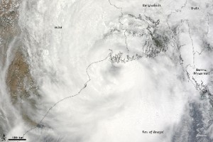
Cyclone Aila 2009
Posted on 01 Jun, 2009 11:27 AMTropical Storm Aila struck southern Bangladesh and eastern India on May 27, 2009. The New York Times reported that floods and mudslides killed at least 191 people and left hundreds of thousands more homeless. As of May 27, the death toll was expected to rise. Images from The Nasa Earth Observatory.
The Moderate Resolution Imaging Spectroradiometer (MODIS) on NASA's Terra satellite captured this true-color image of Aila on May 25, 2009, the same day that the storm temporarily strengthened to a Category 1 cyclone. Aila almost completely fills this scene, stretching from the Bay of Bengal deep into India, Bangladesh, and Burma (Myanmar). On May 25, Aila's wind speeds ranged from 74 kilometers per hour (46 miles per hour or 40 knots) to 120 kilometers per hour (75 miles per hour or 65 knots). More information and detailed images can be accessed here:Cyclone Aila
