Natural Disasters

The term 'Disaster' occurs with such tragic frequency in news reports today, that it seems superfluous to define it. 'Official' definitions are suggested by the United nations and  the Disaster Management Act. Simply put, a disaster is a  rapidly occuring event that leads to loss of lives and property.  Loss is the defining characteristic of a disaster. With the exception of industrial and other manmnade accidents, the cataclysmic events that lead to this loss are necessary landforming mechanisms.

Earthquakes, floods and resultant landslides, cyclones, and other such events are the processes through which the  earth relieves pressure that might be building up in the crust, reforms river beds, and relieves buildup of atmospheric pressure. When humans are caught in the midst of these events and suffer damage and loss, the events are termed disasters. 

It is not to be denied that these events can be catastrophic in their impact.  The Bhola cyclone, in 1970, caused the deaths of 5 lakh people in India. Three decades later, the Orissa cyclone in 1999 killed 10,000 people.
1. Types of disastersNatural Disasters Infographic (Source: Alexandra Curtis)
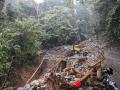
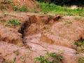
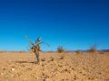
Disasters, events that lead to a considerable loss of  life and property, can occur in several ways. The broadest means of  classfication are as manmade and natural disasters. Manmade disasters include industrial and chemical disasters, stampedes, nuclear emergencies, transportation accidents (road, rail, air  and sea), and mines. These, while important, are not withing the purview of the India Water Portal. The discussion therefore will be confined to natural disasters. Natural disasters of course can be exacerbated by human interference such as in the case of landslides which are intensified by  blasting in mountain areas, and floods which are intensified by inappropriate channelization of  river courses.

2. Dealing with disasters:
Traditional means of managing disasters has been confined to response. This is the  rescue and aid that is given immediately after an event. In some cases, rehabilitation has been done, which is ensuring that the aid that disaster  victims need to begin their lives over again is available. In recent years though, the purview of  disaster management has expanded across the continuum of disasters to include mitigation and reconstruction. These now include:

  • Prevention and mitigation
  • Preparedness and response
  • Recovery, reconstruction and rehabilitation

3. Institutional framework in India
Disaster management in India was earlier predominantly focused towards responding to requests for aid after a disaster. However, the nineties saw  series of catastrophic events which led to the creation of a holistic policy of disaster management. The National Disaster Management Authority (NDMA) was established with the vision of a disaster- resilient India; created by enabling prevention, mitigation, preparedness, and effective response (National Disaster Management Authority, 2009).   They recommend the inclusion of disaster prevention, mitigation and preparedness activities within the scheme of disaster management. The  NDMA also recommends several measures at various levels from the national to the individual. A crucial part of these is the formation of State Disaster Management Authorities which oversee the implementation of  the NDMA policies in their states. An important part of the institutional framework to deal with disasters is the emergence of community-led institutions. These range from pan-regional networks such as HYCOS in  the Hindu Kush Himalayas to the village-based flood alert systems seen in Assam. These are explained in David Molden's talk below:


4. Voluntary organisations
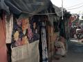
Despite the existence of the National Disaster Response Force, the first responders on the scene are often local communities and voluntary organisations. The outpouring of support that one sees in the immediate aftermath of a disaster is a matter of pride for the nation, as citizens rally together to support the stricken communities. Local communities do stellar work in immediate rescue of afflicted people. This is especially crucial during landslides in the mountains when afflicted areas can be rendered inaccessible. Communities  that are farther away from the scene of the disaster also rally around when it comes to the  donation of supplies such as food, clothing and shelter. However this  community-driven and impulsive response is largely confined to the rescue and response stages. The delivery of relief material can also be inefficiently handled due to the inexperience of the people dealing with the situation.

It is here that voluntary organisations come to the forefront. They usually have a network of contacts and are able to mobilise both goods and personnel in an efficient manner. Past disasters such as the Latur Earthquake, Leh Landslides, and Uttarakhand floods have seen all manner of voluntary organisations from NGOs to religious trusts offer support, time, and goods. Voluntary organisations also offer more than just the supply of immediately required food and clothing by assisting with construction of shelters, medical aid, and provision of sanitary facilities.

This is best offered by non-political volunteer networks and organisations that are largely devoted to the provision of disaster relief. These have access to highly skilled personnel, donor agencies, and government networks which enable them to provide superlative assistance as and when needed.

RedR is such a network composed  of engineers. Volunteers with RedR participate in regular training which enable them to offer skilled assistance in times of disaster. Medicins Sans Frontiers is a network of doctors who provide skilled medical care in times of disaster and strife.

2.  Personal responsibility
A large part of the casualties during disasters can be prevented by taking a few steps. After all, the first person present at the scene of an accident is the accident victim. While some events may have some warning, it is always better to be prepared for the unforseeable.

Please see below for some tips 'Do's & Dont's to protect yourself and your family in case of an emergency: 

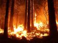
Earthquake         Tsunami        Landslide         Biological            Floods           Cyclone          Nuclear            Heat Wave       Chemical Disaster


Term Path Alias

/topics/natural-disasters

Featured Articles
May 11, 2024 Deforestation, expansion of agricultural land, encroachment into forested areas, and unplanned urbanisation alter landscape connectivity, fragment habitats, and increase fire ignition sources.
Uttarakhand's wildfire wake-up call (Image: Pickpic)
April 25, 2024 Understanding the impact of heat on our world
Rising temperatures, rising risks (Image: Kim Kestler, publicdomainpictures.net)
February 5, 2024 Navigating sustainable development in the wake of legal battles and environmental challenges
The heavy rains and landslides in 2023 have highlighted the city's inability to bear the burden of additional population (Image: Vincent Desjardins; CC BY 2.0 DEED)
November 5, 2023 Honeywell’s environmental sustainability index, a quarterly index reveals a growing number of organisations globally are boosting annual sustainability investments by at least 50%, and are optimistic about achieving short- and long-term objectives
Environmental Sustainability Index gauges movement in corporate sentiment and investment on the sustainability front. (Image: Needpix)
July 14, 2023 These states are at the forefront of flood early warning systems
Previously drought-prone areas are now facing floods (Image: Needpix)
June 16, 2023 Majuli serves as a symbol of both the delicate balance between human activity and the environment and the tenacity of its residents
Addressing various aspects of women's lives to enhance their social, economic, and political status (Image: Rebuild India Fund)
Map showing the site where river Bagmati breached its embankments in Sitamarhi, Bihar in 2009
Mpa showing the spot near Tajpur in Sitamarhi where the Bagmati breached its embankments Posted on 04 Aug, 2009 09:50 AM

The following map from South Asia Network on Dams Rivers & People gives a schematic sketch of the Bagmati Breach site near Tajpur in Bihar’s Sitamarhi district.   

Pictures from the Bagmati embankment breach in Bihar in 2009
These photos were taken by NGO Ghoghardiha Prakhand Swarajya Vikas Sangh, Madhubani Posted on 03 Aug, 2009 10:10 AM

The google map at this URL shows Runi Sayedpur and Sitamarhi, along national highway 77: http://tinyurl.com/lxwfmj

Background documents on the Bagmati embankment breach: Article and presentation
Article and presentations on the Bagmati and its embankments from the Central Water Commission and well known scholar Dinesh Kumar Mishra Posted on 03 Aug, 2009 09:46 AM

1) A presentation from the Central Water Commission of the Government of India studying the flood problem on the Bagmati and making some recommendations:

flood-management-in-bagmati-basin

Cyclone Aila 2009
Cyclone Aila Posted on 01 Jun, 2009 11:27 AM

Tropical Storm Aila struck southern Bangladesh and eastern India on May 27, 2009. The New York Times reported that floods and mudslides killed at least 191 people and left hundreds of thousands more homeless. As of May 27, the death toll was expected to rise. Images from The Nasa Earth Observatory.

aila_tmo_2009145

The Moderate Resolution Imaging Spectroradiometer (MODIS) on NASA's Terra satellite captured this true-color image of Aila on May 25, 2009, the same day that the storm temporarily strengthened to a Category 1 cyclone. Aila almost completely fills this scene, stretching from the Bay of Bengal deep into India, Bangladesh, and Burma (Myanmar). On May 25, Aila's wind speeds ranged from 74 kilometers per hour (46 miles per hour or 40 knots) to 120 kilometers per hour (75 miles per hour or 65 knots). More information and detailed images can be accessed here:Cyclone Aila

NASA Earth Observatory: Cyclone Bijli
A ragged-looking Tropical Storm Bijli draped the east coast of India in this image from the Moderate Resolution Imaging Spectroradiometer (MODIS) on NASA's Terra satellite on April 16, 2009. Posted on 07 May, 2009 12:03 PM

Image & Content Courtesy: NASA Earth Observatory

A ragged-looking Tropical Storm Bijli draped the east coast of India in this image from the Moderate Resolution Imaging Spectroradiometer (MODIS) on NASA's Terra satellite on April 16, 2009. Bijli became a tropical storm in the northwest Bay of Bengal on April 15, and initially headed north, toward the west coast of India. By April 16, it had begun a northeastward turn, however, and the storm was being projected to make landfall in eastern Bangladesh on April 17, according to Unisys. Access higher resolution image here:Cyclone Bijli

Kosi Katha - The making of a famine': Video highlighting the growing famine in the wake of the floods in Bihar
This video from Janmadhyam highlights the plight of those regions badly hit by the recent floods in Bihar where the ugly threat of famine is looming large Posted on 14 Apr, 2009 04:05 AM

The latest loss figures (24 Feb. 09 is five districts, 35 blocks, 33.29 lakh peopla, 9.97 lakh live stock., affected area 3.68 lakh hectares, 2.37 lakh houses, 527 human death a and 19,323 loss of cattle.

Kosi darshan: A deeper look at the lives of those pinned on the river
Dinesh Mishra paints a riveting picture of the state of the villages whose future remains closely intertwined with the Kosi, both in India and Nepal Posted on 31 Mar, 2009 05:14 PM

"If it had not breached at Kusaha, it would have anyway breached at this point," points a villager towards the probable location on the eastern bank in village Rajabaas near Prakashpur in Sunsari district of Nepal, located 14 km upstream of Kusaha where the Eastern Afflux embankment of the Kosi had breached on the August 18, 2008.

ADB to help raise public awareness on climate change
The Asian Development Bank (ADB) has approved a technical assistance grant to raise awareness through the media on the serious threat that climate change poses to hundreds of millions of people in the region. Posted on 13 Mar, 2009 01:44 AM

The Asian Development Bank (ADB) has approved a technical assistance grant to raise awareness through the media on the serious threat that climate change poses to hundreds of millions of people in the region.

Voices from the villages: Workshop notes organized by the Barh Mukti Abhiyan in 2008 to raise awareness about floods across North Bihar
Barh Mukti Abhiyan organised a series of workshops in 2008 (before the unprecedented floods that occurred that year) to raise awareness of the issue and educate itself - Notes from the series Posted on 01 Mar, 2009 02:37 AM

The workshop notes are a record of the actual ground level experiences, understandings/misunderstandings and conversations regarding the floods in North Bihar.

The attached files below are the set of the workshop notes. We welcome comments which will passed back to Barh Mukti Abhiyan.

Polavaram (embankments in Orissa and Chhattisgarh) proposal before EAC
Polavaram (embankments in Orissa and Chhattisgarh) proposal before EAC Posted on 16 Feb, 2009 11:14 AM

Himanshu Thakkar has attached herewith a letter just sent to the members of the MEF's Expert Appraisal Committee on the river valley projcets regarding the application of Andhra Pradesh to the MEF for "backdoor" clearance of the embankments to be constructed in Orissa and Chhattisgarh to "protect" the areas of these states from going under submergence due to the Polavaram project. The letter is self explanatory.

To: Mr. P. Abraham, Chairman,& All the members,Expert Appraisal Committee on River Valley & Hydroelectric projects, c/o Dr Bhowmik,Impact Assessment Division, Ministry of Environment and Forests, CGO Complex, Lodhi Road, New Delhi 110 003

Sub: Objections to EC for Polavaram Multi Purpose Project

Dear Chairman and members of the EAC on River Valley and Hydroelectric Projects, We have come to know from the agenda notes of the 23rd meeting of MoEF's Expert Appraisal Committee for River Valley and Hydroelectric Projects to be held on Feb 16-17, 2009 that the committee will be considering Polavaram Multipurpose Project in Andhra Pradesh by Government of Andhra Pradesh (No. J-12011/74/2005-IA.I) for the proposal for the construction of the embankments to protect the lands in Orissa and Chhattisgarh from going under submergence due to the proposed Polavaram project.

×