Term Path Alias
/topics/droughts-and-floods
/topics/droughts-and-floods
 The greater Himalayan region “the roof of the world” – contains the most extensive and rugged high altitude areas on Earth, and the largest areas covered by glaciers and permafrost outside the polar regions.
Recent scientific studies show that global warming is already causing environmental changes that will have significant global economic and social impacts. As the world's 4th largest emitter of greenhouse gases, India has to juggle the imperative demand for economic development with pressures for greater efficiency in the use of energy.
Climate change is a change in the statistical properties of the climate system when considered over long periods of time, regardless of cause. Climate change reflects a change in the energy balance of the climate system, i.e. changes the relative balance between incoming solar radiation and outgoing infrared radiation from Earth. The threat emanates from accumulated green house gas emissions in the atmosphere, generated through long term and intensive industrial growth and high consumption life styles of developed countries.
Article and Image courtesy: YaleGlobal Online
Author: Rohini Nilekani
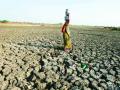
India and China account for one third of the world’s population; each consumes more freshwater than other nations. Per inhabitant per year, though, India uses less than half what’s used in the US, China uses less than one third. This YaleGlobal series examines India and China’s water use, their expectations for rising demand and recognition that shortages will disrupt economic progress.
The Planning Commission of India repeatedly warns that water will become a more serious issue than land or energy for India in years to come, points out Rohini Nilekani, in the second article of the series. India’s transition from an economy based on agriculture to a mixed one, with water use controlled by states rather than the federal constitution, already leads to conflicts. She urges planning for a low-water economy. Good governance and regulatory frameworks can prevent pollution and waste, while encouraging efficiency, reliable and fair allocation, and wise consumer choices.
 Thirsty earth: Indian villagers in Gujarat gather to draw water from a well
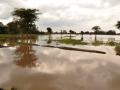
This paper in Journal of Earth System Science attempts to estimate the possible rate of land subsidence of Kolkata City including Salt Lake City and the adjoining East Kolkata Wetlands located at the lower part of the deltaic alluvial plain of South Bengal basin. Land subsidence is an environmental hazard which is caused by overdraft of groundwater or oil extraction and results in gradual settling or sudden sinking of the earth’s surface owing to subsurface movement of the materials of the earth.
It indicates that the aquatic ecosystem of an area disappeared due to unplanned development of agro ecosystems and human settlements. This area was earlier covered with ponds, wetlands and ox-bow lakes. Now, during the rainy season, inhabitants of these wards face severe problem of water logging and pollution.
Article courtesy: Corporate Disaster Resource Network
Assessment team:
Oxfam India – Mr. Pradeep Bharwad (Technical Assistance), Mr. Bhaswar Banerjee, Mr. Amit Sengupta
Save the Children - Mr. Abinash Lahkar, Mr. Piyush Kumar
Kajla Jana Kalyan Samity - Tapas Jana and Dipak Banerjee
Areas assessed: Moyna & Panskura Block of East Midnapore District of West Bengal
Assessment date: 24th June, 2011
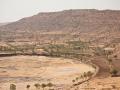
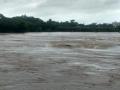
Kosi is known as the sorrow of Bihar due to its frequent and often disastrous floods. The major geomorphic units of flood-inundated area in Kosi fan (terrain of Kosi river in India) are sand bars in the form of inter-connected drainage networks, an ox-bow lake and its meandering cut-off and imprint.
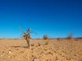
Climate modeling studies indicate that there will be more spells of intense rainfall and frequent instances of extreme rainfall. This prediction is coming true, particularly in the central sector of the Himalayan belt, where there is pronounced decline in winter precipitation (both rain and snow) and prolonged spells of drought in summer broken by cloudbursts in localized areas.
 Some policy measures implied by various options have also been indicated. The main sectors examined in the report are power, transport, industry, buildings and forestry.
Increased concentrations of Green House Gases (GHGs) and the overall warming of the atmosphere has resulted in changing rainfall patterns, disruption in hydrological cycles, melting of ice caps and glaciers, rise in sea levels, and increase in frequency and intensity of extreme events such as heavy precipitation and cyclonic activities.
These have in turn had serious impact on sustainability of water resources, agriculture, forests and ecosystems, affecting the well being of billions of people on earth. Widespread melting of glaciers and snow cover will reduce melt water from major mountain ranges (e.g. Hindu Kush, Himalaya, Andes) where more than one billion people currently live.
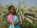
 The survey aims to cover major crops and suggestions to farmers on how to take preventive steps to avoid yield loss. There will also be a special article on improvement in living conditions of the rural people.
Contents
Section-1
Overview:
Enhancing the disaster resilience of agriculture
Prof. M.S. Swaminathan
Drought:
Preparedness to face drought challenges
Dr. V. Rajagopal