Term Path Alias
/sub-categories/research-papers
/sub-categories/research-papers
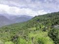
Forests are a primary source of food, water, medicine, fruits, shelter, bedding materials, fuel, fodder, and appliances for agriculture in rural areas, globally. The ‘sacred natural forest sites’ in the Himalayan mountains are a common center of different cultures, social groups, traditions, and beliefs.
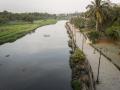
A rare species of catfish, has been found in aquifers in Kerala, opening a window to the rich biodiversity that exists even in deep and dark underground subterranean environments where unique organisms survive by adapting to the harsh surroundings informs this paper titled 'Evolution in the dark: Unexpected geneti

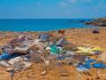
A sizeable segment of the workforce in India relies on the informal sector as their main source of income. One such activity is waste management, which is carried out informally or is organised through associations and cooperatives.
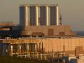
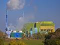
With the ever-increasing demand for energy in a rapidly growing economy like India, cheap and sustainable energy is the need of the hour. Waste-to-energy conversion remains a major untapped energy resource in the Indian context.
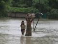
India is heating up
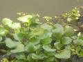
Water hyacinth, a devil in disguise
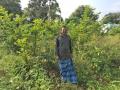
Agroforestry enhances farmers’ ability to adapt to climate change and delivers multiple ecological, social, and economic benefits.
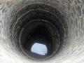
The state of Tamil Nadu depends heavily on groundwater for domestic, industrial, and agricultural use and this has led to rapid depletion of groundwater resources in the state. Over-extraction in hard, arid rock areas like the districts of Dharmapuri and the alluvial Cauvery delta is very high and farmers continue to drill deeper wells.
The large volume of wastewater remains untreated due to inadequate wastewater treatment facilities and the struggle to regulate it in many countries in the world. But it is being reused as a source of irrigation in urban and peri-urban areas.
Water shortage has become a serious barrier to the development of many areas of the world in the context of global warming. This has prompted the development of novel desalination techniques for brackish and seawater.