/regions/orissa
Orissa
Odisha Flood Alert - II issue 2010
Posted on 09 Aug, 2010 05:14 PMThis initiative is an attempt to provide daily updates on Flood Situations and related events/news to water enthusiasts, professionals and citizens concerned about flood in Odisha. News and information collected from Odia news papers, English media (internet editions) and web site of Department of Water Resources, Govt of Odisha are put together at one place to provide an overview of flood in Odisha on a daily basis.
Second issue of quarterly Odisha river basin news
Posted on 30 Jul, 2010 12:55 PM![]()
We had mentioned while dispatching our 1st Issue of River Basin Transact that the present pace and direction of development bandwagon in Odisha, made it imperative for its civil society and citizens alike to give more attention to its rivers, before it became too late.
During this quarter (Apr-Jun), there are quite a few such civil society responses towards redefining the way our rivers are being managed. While Dakshin Odisha Vikash Parishad (DOVP) came up with a suggestion to have Integrated River Valley Project in line of TVA in USA to manage South Orissan Rivers, State Govt resolved not to allow any new industry to draw water from the Brahmani and the Baitarani. Towards the end of the quarter alignment of civil society and political parties around MBA (Mahanadi Banchao Andolan) to protest diversion of Mahanadi water to POSCO and IOC made the headlines local dailies.
Daily rainfall-runoff modeling of Brahmani river at Rengali reservoir, Orissa – A research report by National Institute of Hydrology
Posted on 24 Jul, 2010 05:50 PMThe report presents a hydrologic simulation model, HYSIM for modeling the daily flows of the Brahmani river at Rengali reservoir in Orissa. Considering the large catchment area of 25,250 sqkm at Rengali reservoir, for modeling purposes the basin has been divided into two sub-basins viz, Upper Sub-basin and Lower Sub-basin. The Upper Sub-basin having a catchment area of 16,900 sqkm up to Bolani gauging site is treated as a nominal sub-basin since the daily flows from this sub-basin as recorded at Bolani gauging site are available.
Dam break analysis of Ghodadoha project in Orissa – A research report by National Institute of Hydrology
Posted on 20 Jul, 2010 07:54 PM
Ghodadoha is a rock-filled earthen dam located in one of the tributaries of the Rushikuliya river of Orissa.
Rainfall-runoff modeling using Artificial Neural Network technique for Baitarni river in Orissa – A Research Report by National Institute of Hydrology
Posted on 20 Jul, 2010 07:21 PMThe research study attempts to develop a rainfall-runoff model using the Artificial Neural Network (ANN) technique for the Baitarni river in Orissa. A detailed review of the research work in the area of interest revealed that the approach of neural computations was very effective in developing the required model, due to its various advantages. Accordingly, three candidate models based on ANN architecture were developed for the study area, to represent rainfall-runoff transformation.
A rapid geohydrological study of microwatersheds from Bolangir district, Orissa state - A report by ACWADAM
Posted on 16 Jul, 2010 03:50 PM This document by ACWADAM is a report of a rapid geohydrological assessment of some of the microwatersheds from parts of Bolangir district Orissa.
Bolangir district in Orissa forms a part of one of the hottest and backward regions of India with low land-productivity, and opportunities and technologies for agriculture in the district remain relatively unexplored.
Vagaries of rainfall and the underlying hard-rock geology further compound the problem and limit agricultural productivity to a great extent. Given such natural uncertainties, systematic implementation of a watershed management programme is the most viable avenue to overcome the problems of this region.
Bolangir district was thus selected as pilot area to conduct a pre-feasibility exercise for planning of water resources management. ACWADAM, Pune was invited, along with Samaj Pragati Sahayog, Bagli to conduct this pre-feasibility exercise.
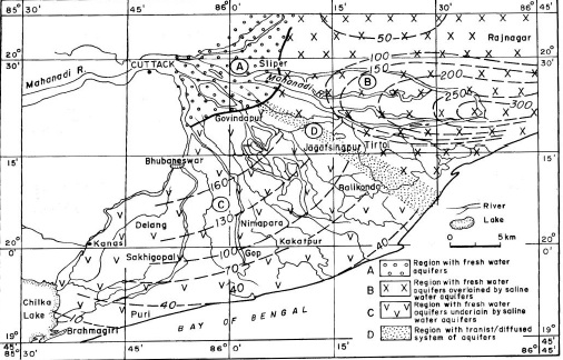
A study of saline freshwater interface phenomena in the Mahanadi delta region (Orissa)
Posted on 10 Jul, 2010 10:40 PM The subsurface aquifer systems in Mahanadi delta region in Orissa (India) is largely characterized by two groups of freshwater aquifer systems, both of which are prone to saline water mixing/migration with time and development:
- The south western Mahanadi delta region is represented by unconfined to semi-confined freshwater aquifers underlained by brackish/saline aquifer systems with a diffusion boundary.
- The north eastern parts of Mahanadi delta is represented by deep freshwater confined aquifers overlained by brackish/saline water aquifers with aquitard/ aquiclude boundary.
A study of saline freshwater interface phenomenon in the Mahanadi delta region, Orissa
Posted on 02 Jul, 2010 04:47 PMABSTRACT
Orissa, the first state to draft the Climate Action Plan
Posted on 02 Jul, 2010 04:42 PMOrissa becomes the first state in the country to have earned the distinction of having action plan on climate change. Following the National Action Plan of India started in 2008 the document of Orissa provides the action for the period of 2010-2015 having a budget of 17,000 crore.
Daily rainfall-runoff modeling of Rushikuliya river - A research report by National Institute of Hydrology
Posted on 29 Jun, 2010 10:29 AMIn this study, a Hydrologic Simulation Model (HYSIM) is applied to the Rushikuliya river basin in Orissa to model the daily flows of the river at Purushottampur. The model used in the study is a menu-driven PC based version and contains modes both for optimization and production runs.
