/regions/india
India
Rain shocked: A Down To Earth's study on the effects of climate change on precipitation patterns in India
Posted on 20 Aug, 2009 05:11 PMThis research study (Mar 15 2009) throws light on how climate change is leading to a rising trend of short but intense spells of rainfall, which is making usable water scarce in India.
Augmenting groundwater: The basics on how to construct a recharge well
Posted on 20 Aug, 2009 05:10 PM

Informative and detailed slideshows on all things related to household rainwater harvesting
Posted on 20 Aug, 2009 04:34 PMSeven easy steps to constructing a recharge pit
Read More
The making of a recharge well
Read More
Mapping water pollution and groundwater depletion due to industrial activities in India
Posted on 20 Aug, 2009 04:28 PMThis map provides the of levels of water pollution and groundwater depletion due to industrial activities in different parts of India.
Mapping the soils of India: Survey of India
Posted on 20 Aug, 2009 04:11 PMSoils constitute the upper portion of the earth's crust, and are the base of human habiation on the earth. India has a great variety of soils, with over 29 major types.
The map can be accessed from the Survey of India website
Download the map from the link provided below:
Fed by rain - India's rainfed and poorest areas overlap
Posted on 20 Aug, 2009 03:52 PMConsisting mainly of arid and semi-arid areas and the country's 200 backward districts, these rainfed regions are concentrated in 13 states.
Map: Location of water resource projects across river basins in India
Posted on 20 Aug, 2009 03:23 PMThe map indicates that across the main 19 river basins of the country, water resource projects with a total live storage of 174 BCM (Billion Cubic Metres) have been completed, 75 BCM are ongoing, and 132 BCM are being planned.
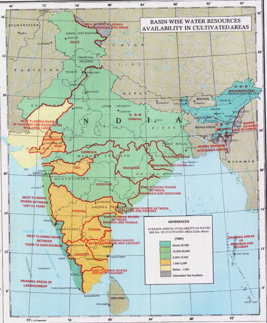
Annual average availability of water for agriculture in India as of 1991
Posted on 20 Aug, 2009 02:50 PM
Rashtrita Jal Chetna Yatra: Efforts of Tarun Bharat Sangh and Rajendar Singh in addressing water related concerns across the country
Posted on 20 Aug, 2009 02:20 PMTarun Bharat Sangh and Rajendar Singh started a massive campaign to spread awareness of traditional water harvesting structures in order to restore the water resources of arid Rajasthan. The aim was to popularize the use of such traditional structures across the country.
Map: Average annual temperature in India
Posted on 20 Aug, 2009 02:15 PMThis map from Wikimedia provides information on the average annual temperature figures across the country over a range of below 20 Deg C and above 27.5 Deg C.