/regions/arabian-sea
Arabian Sea
IWMI International workshop on Indus-Gangetic Basin project
Posted on 02 Dec, 2009 12:10 AMIt looked unreal then! It appeared a little relevant afterwards. Centuries later it made sense. And only in the recent times has the intensity and appropriateness of Leonardo Da Vinci's observation that water is the driver of nature, struck us!
The many large scale impacts of climate change
Posted on 26 Aug, 2009 01:50 PMThe heat evaporates the moisture in the soil rapidly leading to widespread drought conditions. The changes in ocean temperatures are modifying the ocean currents, thus creating erratic and extreme weather conditions - creating more intense and frequent storms and cyclones; thus creating cycles of floods and drought.
River basins and river basin organisations in South Asia
Posted on 22 Jul, 2009 03:12 PMAs part of the research study, River Basins and River Basin Organisations in South Asia, done by the Society for Participatory Development Hyderabad, CapNet South Asia (Read More) and Gomukh Environmental Trust for Sustainable Development Pune (Click Here), data about individual river basins has been collected for the river basins in South Asia.
Concurrent monitoring of the world's largest drinking water pipeline project - A study of Narmada based project in Gujarat
Posted on 27 May, 2009 02:56 PMThis report presents the findings of a study done by Pravah on the concurrent monitoring of the world's largest drinking water pipeline project, the Narmada project, which is supposed to cover 9633 villages an 131 towns of Saurashtra, Kutch and parts of North Gujarat.
Erosion response model for watershed prioritisation in Bajaj sagar sub catchment, Mahi basin
Posted on 12 May, 2009 11:55 AMThis case study presents a erosion response model for watershed prioritisation in Bajaj sagar sub catchment of Mahi basin. The natural hydrologic processes like erosion of soil, movement of soil and its deposition in various parts of reservoir are very crucial phenomena occurring in any watershed. Erosion of soil is a very complex process which is affected by many factors and the loss caused is irreversible.
Micro-watershed development plans using remote sensing and GIS for Shetrunji river basin in Bhavnagar district, Gujarat
Posted on 11 May, 2009 04:21 PMMicro-watershed level planning requires a host of inter-related information to be generated and studied in relation to each other. Remotely sensed data provides valuable and up-to-date spatial information on natural resources and physical terrain parameters.
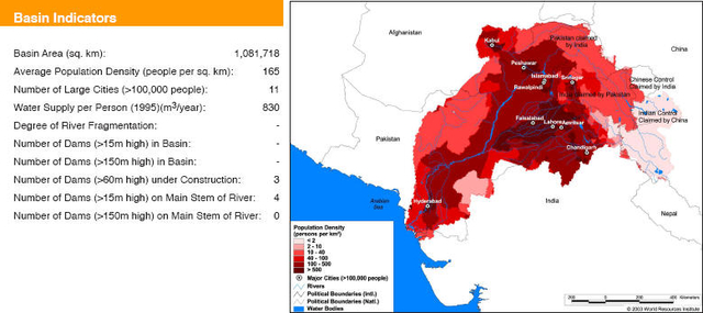
Basin maps of Indus river showing basin indicators, landcover classes and biodiversity information and indicators
Posted on 17 Apr, 2009 01:05 PM
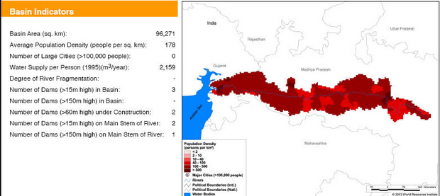
Basin maps of Narmada river showing basin indicators, landcover classes and biodiversity information and indicators
Posted on 17 Apr, 2009 12:55 PM
Basin indicators map of Narmada river basin
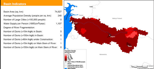
Basin maps of Tapti river showing basin indicators, landcover classes and biodiversity information and indicators
Posted on 17 Apr, 2009 10:37 AM
Basin indicators map of Tapti river basin
Compilation of data for Cauvery basin for river basin planning along with maps of major river basins of India
Posted on 17 Apr, 2009 09:49 AMWater flows without regard to political and administrative boundaries. Water planning with respect to rivers should therefore be done for the river basin (or sub-basin) as a whole. River basin planning also has to look in an integrated way at all the relevant parameters like urban and rural populations, water usage patterns, water pollution, wastewater flows.