Term Path Alias
/regions/arabian-sea
/regions/arabian-sea
Article Courtesy : Hydrology and Earth System Sciences (HESS)
Authors : A.N. Laghari, D.Vanham, and W.Rauch
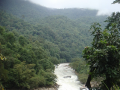
River stories from Maharashtra: Many morals to learn
Parineeta Dandekar’s presentation began with an account of some statistics related to Maharashtra, the third largest state in India. Regarding the state of water resources in Maharashtra, she noted that of the five river basin systems, 55 percent of the dependable yield is available in the four river basins (Krishna, Godavari, Tapi and Narmada) east of the Western Ghats. These four river basins comprise 92 percent of the cultivable land and more than 60 percent of the population in rural areas. 45 percent of the state's water resources are from west flowing rivers which are mainly monsoon specific rivers emanating from the Western Ghats and draining into the Arabian Sea.
With 1821 large dams and more in the offing, Maharashtra has the maximum dams in the country (35.7%). However, the proportion of gross irrigated area vis a vis the gross cropped area at 17.8 percent is much lower than the national average of 44.6 percent. The contradictions from the state, which is home to the highest number of dams, were discussed. In nearly 70 percent of the state’s villages (around 27,600 villages), water is either not available within 500 metres distance, or within 15 metres below ground level or when available is not potable (World Bank, Promoting Agricultural Growth in Maharashtra, Volume 1, 2003).
Dandekar discussed the World Bank funded Maharashtra Water Sector Improvement Project (MWSIP) initiated in 2005 whose main components were establishment, operationalisation and capacity building of Maharashtra Water Resources Regulatory Authority (MWRRA); establishment of river basin agencies in Maharashtra; and restructuring and capacity building of the Water Resources Department. The MWRRA Act (2005) has been amended, taking out the clause for equitable water distribution, and granting the Cabinet the rights to have the last say about water entitlements. This has led to a diversion of water for irrigation from the vulnerable, suicide-prone Vidarbha region to thermal power plants. According to Prayas, “entitlements of more than 1500 MCM have been changed from agriculture to industries and cities”.
Sabarmati Riverfront Development (SRD) project, an urban mega-project in Ahmedabad has been proclaimed as a case based on “flexible governing” of the residents of the riverfront informal settlements.
Guest post by: Parineeta Dandekar
It traces the roots of the conflicts to the strained relations between India and Pakistan following the partition and the framing of the Indus Water Treaty in 1960.
Guest Post: Forum for Policy Dialogue on Water Conflicts in India
The Forum for Policy Dialogue on Water Conflicts in India has been closely following the Mullaperiyar issue for the last several years. The polarisation of views around the Mullaperiyar has hardened over the years. The Tamil Nadu government insists that the Mullaperiyar dam is safe and that the water level must be maintained at the maximum level as per the agreement. The Kerala government insists that a new dam, downstream of the present dam, must be built because the present dam is unsafe. The recent tremors with their epicentres near the dam and the already diminishing trust and rising fears and apprehensions on both sides have created a grave situation needing immediate intervention and your initiative in getting the two parties together is a welcome move.
 This report by the Kerala State Council for Science, Technology and Environment (KSCSTE) and Centre for Water Resources Development and Management (CWRDM) on water quality monitoring in Kerala covers all its forty four river basins. This is being done under the “Environmental Monitoring Programme on Water Quality” under which samples are being collected both from surface and groundwater sources.
Groundwater sampling stations were fixed after conducting a sanitary survey in the panchayats. Water Quality Information System is being developed using Geographical Information Systems (GIS) to manage the water quality from point or non-point source of pollution.
In the first phase of the project, three river basins of Kerala viz. Kabbini, Periyar and Neyyar were monitored. The network was later expanded to basins such as Chaliyar, Kadalundi, Meenachil, Karamana, Anjarakandi, Pamba, Muvattupuzha, Bharatapuzha, and Chalakudy.
This paper in the Journal of Earth System Science deals with a study by National Institute of Oceanography (NIO), Goa to investigate the influence of monsoonal rainfall on hydrographic conditions in the Mandovi River of India. The study was undertaken at a location approximately 2 km upstream of the mouth of the estuary.
The Level-I Laboratories are located at 258 field water quality monitoring stations on various rivers of India where physical parameters such as temperature, colour, odour, specific conductivity, total dissolved solids, pH and dissolved oxygen of river water are observed.