In an effort to inform the general public, especially citizen activists, policymakers, researchers, and students, about the current status of the Vrishabhavathi river, Paani.Earth has created the necessary maps, data, analysis, and information to drive conservation awareness and action around the river.
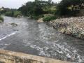
In an attempt to present a perspective on how rivers are used and abused, a map of the Bengaluru rivers illustrate how waste flows through natural river corridors, polluting the rivers and altering their status.
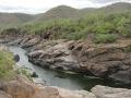
The eighth lecture in the series titled "Living rivers, dying rivers" was on Vrishabhavathi-Arkavathi rivers, by Leo Saldanha and Bhargavi Rao of the Environmental Support Group (ESG).