Term Path Alias
/topics/forests
/topics/forests

Content and Image Courtesy: The Press Club Mumbai

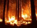
Screening of Award winning film ‘Niyamgiri You Are Alive’ by Suma Josson. The film won the Vasudha Award for the best environmental documentary in the International Film Festival Goa, 2010.
Guest Post: Text by Amitangshu Acharya, Photographs by Ayan Ghosh
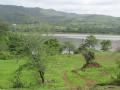
Kachchh – a brilliant halfway between a turmeric yellow Rajasthan and the emerald green Sahyadris – offers an upside down version of life. It tells you that seeds of life and civilisation are often hidden beneath the sands of time in inhospitable terrains.

Content Courtesy: Flowers of India
Jungle Trees of Central India is a lovingly detailed field guide to every tree you're likely to see in the magnificent dry, deciduous forests of the region. Bigger than France and encompassing 5 of India's most visited Tiger Reserves, Central India is home to the classical types of wilderness that one associates with the term 'Indian Jungle'.
Forwarded to the portal by: Manshi Asher
Content Courtesy: Himvani
Author: Renuka Bandh Sangharsh Samiti
Despite protest against forced acquisition of land, Himachal Pradesh Power Corporation Limited (HPPCL) and revenue administration today notified Section 9 of the Land Acquisition Act 1894, for approximately 680 big has (about 57 hectares) of land of Panaar Village for the Renuka Dam Project. In a letter to the Chief Justice of Himachal Pradesh High Court sent today, activists appealed for a stay on land acquisition for the project, considering the uncertainty surrounding the project.
 This paper by Rajasthan Pollution Control Board on climate change impacts in the context of Rajasthan seeks to address the issue of need of the society for robust knowledge to pursue strategies for mitigation as well as adaptation in order to address the challenges associated with global warming and climate change.
Accordingly, here a brief review of the available literature and an annotated bibliography of published research on climate change impacts, mitigation and adaptation in order to facilitate the identification of policy options in Rajasthan is provided.
Also included is the literature on how human societies contribute to environmental change and how, in turn, become vulnerable to these changes. It also explores the available knowledge on how likely ecosystem goods and services are impacted to climatic oscillations (environmental sensitivity) and the ability of rural communities to cope (social resilience) with those changes.
This document in Hindi prepared by the Gandhi Peace Foundation, is a blueprint of the Himalayan People's Manifesto. The manifesto has been brought out with the help of various documents prepared by various people and organisations at different times. It will be finalised by the next Himalayan Day on September 9, 2011.
23rd November 2010, New Delhi
 This report prepared by the Indian Network for Climate Change Assessment (INCCA) provides an assessment of impact of climate change in 2030s on four key sectors of the Indian economy, namely agriculture, water, natural ecosystems & biodiversity and health in four climate sensitive regions of India, namely the Himalayan region, the Western Ghats, the Coastal Area and the North-East Region. This is the for the first time that such a comprehensive, long term assessment has been undertaken based on rigorous scientific analysis for the 2030s (all previous assessments were for the 2070s and beyond).
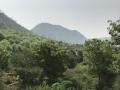
The Mizoram state has three types of (natural) lakes: valley lakes, tectonic/landslide lakes and artificial reservoirs, but the only lake of significance is Palak Dil, which is a natural lake in a depression in the hills. Palak Dil may possibly be a combination of valley and tectonic lakes. Locally in Mizoram, lakes are called dils. There are many such dils scattered all over the state, but they are tiny pools or marshy depressions such as Rengdil, Tamdil and Mampui Dil (Choudhury 2002). The Palak Lake is situated within the Mara Autonomous district Council, which is a region inhabited by the Mara Tribe. The Maras are distinct from the majority Mizos and in the Mara language the Palak Lake is referred to as Pala Tipa.

Climate Change
Environment