Term Path Alias
/topics/forests
/topics/forests

Guest post by: Parineeta Dandekar
The Durban climate negotiations have set into motion new negotiations, with the possibility of re-opening old and contentious issues, while at the same time leaving the global climate regulatory framework unchanged. While disappointing, this does create a possibility of starting anew.
The Indian government and two other Indian authorities have signed an agreement on October 22, 2011 regarding construction of the Tipaimukh Dam.
The main objectives of the hydropower study are as follows:

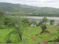
Map of the north-east states
It broadly covers five core parameters, viz., biodiversity, atmosphere, land/soil, water and human settlements suggested by the Framework for Development of Environment Statistics (FDES) published by United Nations Statistics Division (UNSD) in 1984.
Point of use household water treatment is the process of treating water at the household level to improve its microbiological purity. In cases where treated municipal water is not available, or is subject to recontamination due to a faulty distribution system, household water treatment is essential and allows families control over their drinking water.
It is evident that the domestic resistance to the project was variously compromised by nationalist rhetoric, imperatives of state development and absence of transnational support. The Hirakud dam project has failed on all of its objectives – flood management, hydropower production, irrigation and navigation. Its socio-economic impact has been devastating.
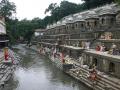
Bagmati river in Kathmandu: From holy river to unthinkable flowing filth
")
Ajaya Dixit initiated his presentation with a general account of how rivers shape the landscape and how riverine ecosystems have nurtured society and kept civilisations vibrant, cultured and creative. Dixit went on to discuss the basin characteristics of the Bagmati, a tributary of the Kosi that rises in the Shivapuri hills, north of the Kathmandu valley. Around fifteen percent of the basin area (3700 sqkm) lies in Nepal, while the remaining is in India. The average annual rainfall in the basin is 1400 mm and is more than 2000 mm in the hills. Bagmati is a seasonal river with rainfall and springs as its main source. Its mean flow is 15.6 cubic metre/second and low flow is 0.15 cubic metre/second in April.
Kathmandu lies in the Upper Bagmati basin and studies suggest that an ancient lake called the Paleo-Kathmandu lay within the Kathmandu valley as a lacustrine formation. Early settlers lived in lower slopes and used springs and river in the upper reaches. When they moved to the valley floor, they built dongia dharas, which are stone water spouts fed by the unconfined aquifers and delivered water through surface channels. Even today, dongia dharas dated back to 1500 years exist. The state built canals (raj kulo) tapped the upper stretches of the rivers close to the mountains. Rivers and irrigation helped recharge aquifers and ponds.
However, rising urbanisation has damaged these ancient artifacts. Over the last sixty years Kathmandu has expanded massively and its population has increased from 0.41 million in 1951 to 2.6 million in 2011. The city has a huge transient population aside from this, reducing it to a concrete nightmare. Seismologists suggest that Kathmandu is a rubble city in the making. Though the Bagmati river flow has not changed significantly in the last seventy years, the character of the river has been transformed significantly during the period 1970 to 1990. The river has been canalised while the dumping of the city’s garbage into it continues. Dixit identified a plethora of problems faced by the river such as upstream water diversion for drinking water needs, disposal of untreated liquid waste, disposal of solid waste, river jacketing for roads and commercial activities, sand mining and physical encroachment.
The state of the river is an outcome of the current approach to waste management particularly liquid waste management. Three types of waste water namely yellow water flux, grey water and yellow black flux are being generated and flowing water is being used as a vehicle to dispose these. The idea of a water based disposal system e.g. flush toilet embedded in Victorian engineering has led to a technological lock-in with the result that the notion of a natural hydrological cycle has undergone a fundamental transformation.
All the same, the bulk of the load in the river is biological though there are some factories releasing effluents. In the last 20 years some of them have been closed or relocated and the river now stands a chance of being salvaged.
It has been dominated by reports of a major cyclone Thane that lay centered on the the 29th December 2011 near latitude 12.30N and longitude 83.00E, about 300 km east-southeast of Chennai (Tamilnadu) and 480 km north-northeast of Trincomalee (Sri Lanka). Earlier reports related to the cyclone Thane indicate predictions and cyclone warnings made by the IMD for the north of Tamil Nadu and the south Andhra Pradesh coast along with possibility of heavy rains and severe winds and warnings for fishermen to refrain from going into the sea.
Later reports indicate that Cyclone Thane has hit the landfall between the Union territory of Puducherry and neighbouring Cuddalore district in Tamil Nadu at about 9 am leaving behind a trail of devastation followed by later reports of weakening of the cyclone activity and predictions of heavy rainfall over Kerala, south interior Karnataka and north interior Tamil Nadu
Content courtesy: National Alliance for People's Movements
On the 26 December, 2011, at 2:15 am, Assam Police in collusion with other security forces swooped down on the protesters at Ranganadi who have been blockading the Highway since December 16 and thwarting state’s attempt to carry turbines and dam materials to project site of Lower Subansiri Dam. Nearly 200 people have been arrested and earlier also security forces have been harassing the protestors. In past too, Krishak Mukti Sangram Samiti fighting against the big dams on Brahmaputra have faced government’s ire and often been attacked and jailed. NAPM stands in solidarity with KMSS and other students groups of the region who have been consistently opposed to the big dams in highly sensitive seismic zone. We condemn the sustained action and harassment of KMSS and their activists and targeting of Akhil Gogoi for constantly opposing the destructive development policies and corruption of the government machinery.