Term Path Alias
/regions/tehri-garhwal-district
/regions/tehri-garhwal-district
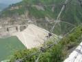
Water level in Tehri dam near danger mark
Throughout history, the Uttarakhand Himalayas have been a source of timber and water to the rest of the nation. However, this has led to severe depletion of resources in the state. Today, the mountain communities find it hard to meet their basic needs of fodder, fuel and water.
The report presents the preliminary results of a hydrological study in Danda watershed, a small hilly watershed located in Tehri-Garhwal, representative of the mountainous sub-humid agro-ecological region in the western Himalayas.
The study attempts to quantify geomorphological characteristics, generate various thematic databases in Geographic Information Systems (GIS) format and derive landuse information using remote sensing digital data for the Danda watershed in the Tehri-Garhwal district of Uttarakhand. Based on these it develops a land capability classification and generates alternate land use plan.
An integrated approach is followed wherein remote sensing and Geographical Information systems (GIS) techniques have been utilized for evaluation of the catchment characteristics such as geomorphology, landuse, soil and slope. The linking of the geomorphological parameters with the hydrological characteristics of the basin provides a simple way to understand the hydrologic behavior of the basin.
This study by the National Institute of Hydrology deals with the geomorphologic & land use planning for Danda watershed in Tehri Garhwal district of Uttar Pradesh.