/regions/rivers
Rivers
Cyclone Aila 2009
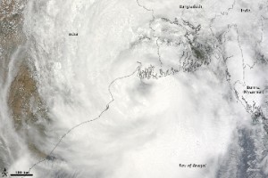
Posted on 01 Jun, 2009 11:27 AMTropical Storm Aila struck southern Bangladesh and eastern India on May 27, 2009. The New York Times reported that floods and mudslides killed at least 191 people and left hundreds of thousands more homeless. As of May 27, the death toll was expected to rise. Images from The Nasa Earth Observatory.
The Moderate Resolution Imaging Spectroradiometer (MODIS) on NASA's Terra satellite captured this true-color image of Aila on May 25, 2009, the same day that the storm temporarily strengthened to a Category 1 cyclone. Aila almost completely fills this scene, stretching from the Bay of Bengal deep into India, Bangladesh, and Burma (Myanmar). On May 25, Aila's wind speeds ranged from 74 kilometers per hour (46 miles per hour or 40 knots) to 120 kilometers per hour (75 miles per hour or 65 knots). More information and detailed images can be accessed here:Cyclone Aila
Use of GIS-based software for hydrological and water allocation modeling - Malaprabha river basin - Karnataka - Technical briefs from the India-PES collaborative project
Posted on 28 May, 2009 12:28 PMThe India-PES initiative, was a collaborative effort undertaken on a pilot basis, by CISED and NIVA, for the development of integrated tools and consulting s
Hydrology and water allocation in Malaprabha - comprehensive database and integrated hydro economic model for selected water services in the Malaprabha river basin
Posted on 28 May, 2009 10:26 AM This study by CISED and NIVA aimed at the development of a comprehensive database on the status of water sector and the development of integrated hydro economic model for selected water services in the study area of the Malaprabha basin. The study focused on exploring the feasibility of Payment for Watershed Services (PWS) to improve the water availability through a detailed analysis of the historic hydrologic data and development of a framework of hydrologic and water allocation model. A hydro-allocation model was developed using the software - ArcView SWAT (AVSWAT) and MIKE-BASIN models.
Integrated river basin modeling framework to support payments for watershed services by Norwegian Institute for Water Research (NIVA)
Posted on 28 May, 2009 10:07 AMThis report by NIVA and CISED has been prepared as part of the India-PES initiative, which was a collaborative effort undertaken on a pilot basis, by CISED and NIVA, for the development of integrated tools and consulting services for Watershed Management and 'Payments for Environmental Services' (PES) in India. Tools and methodologies developed as part of this initiative were tested in the Malaprabha river basin in the state of Karnataka, and the PES implementation was focussed on Participatory Irrigation Management.
Concurrent monitoring of the world's largest drinking water pipeline project - A study of Narmada based project in Gujarat
Posted on 27 May, 2009 02:56 PMThis report presents the findings of a study done by Pravah on the concurrent monitoring of the world's largest drinking water pipeline project, the Narmada project, which is supposed to cover 9633 villages an 131 towns of Saurashtra, Kutch and parts of North Gujarat.
Spatial modelling approach to water pollution monitoring in the sugar belt of Maharashtra along the Krishna river
Posted on 20 May, 2009 12:49 PMThis paper on the GIS Development site highlights the findings of a study taken up for the monitoring, identification and suggesting preliminary measures of water pollution cont
Geographic information system (GIS) and groundwater for windows (GWW) helps in creating interactive groundwater information system (GWIS) of Barakar basin in Bihar
Posted on 20 May, 2009 10:21 AMThis paper on the GIS Development site discusses the approach adopted for establishing ground water information system (GWIS) of the Upper Barakar Basin using geographic informati
Groundwater prospects analysis through hydrogeophysical parameters and hydrogeomorphic zonation - a case study in parts of Kewta watershed - upper Barakar basin - Bihar
Posted on 19 May, 2009 01:43 PMIn this paper from the GIS Development site present study, hydrogeomorphic zonation has been carried out through remote sensing technique.
Analysis of hydrogeophysical properties of aquifer and reserve estimation for sustainable development of groundwater in Kewta watershed, Hazaribagh, Bihar
Posted on 19 May, 2009 01:39 PMIn this study from the GIS Development site, the hydrogeophysical parameters generated from vertical sounding, geohydrological, inferred fractures and geomorphic zones derived from remotely sensed data have been analysed in Kewta watershed of upper Barakar Basin, Hazaribagh. The study area is part of lower Hazaribagh plateau and is part of pediplain developed over Chotanagpur granite gneiss and meta- sedimentary.
Groundwater markets in Ganga-Meghna-Brahmaputra basin: theory and evidence - a review
Posted on 18 May, 2009 04:37 PMThis paper published in Economic and Political Weekly reviews 13 papers (from 1974 to 2003) on groundwater markets in the region, in order to understand the role of groundwater
