Term Path Alias
/regions/political
/regions/political
The study provides an analysis of groundwater quality to identify probable pollution or contamination in coastal aquifers of Kakinada in Andhra Pradesh. Sampling surveys have been conducted in the months of May 99, August 99 and November 99 and about 186 water samples were collected from shallow wells, filter points, canal water and rainwater. The spatial and temporal variations of water quality parameters are presented in the report.
The report presents a sedimentation study in which sedimentation rate and volume have been determined using remote sensing data in the Ukai reservoir constructed across the Tapti River in Gujarat.
The report deals with software developed by the National Institute of Hydrology with the purpose of preparation of hydrological data book in a form most valuable to the users. A menu driven, user friendly software has been developed to handle all types of hydrological and meteorological data.
The Ministry of Environment and Forests released a draft of the regulatory framework for wetland conservation - Wetlands Conservation and Management Rules (2009) for feedback from all stakeholders. The draft framework was prepared by a multi-disciplinary expert group, and final round of comments were invited till June 21st 2010.
The Wetland Conservation Team of Ashoka Trust for Research in Ecology and the Environment (ATREE) did a detailed analysis of the draft regulation and submitted several pertinent concerns to the Ministry. The most significant observation is that the new framework (as do much of India's policies and laws) continues to propose unjustifiable State control and interventions over the country's wetlands and livelihoods of people dependent on them. The regulation does not make any constructive suggestions or recommendations for the conservation that the country's wetlands demand, and instead brings all wetlands into complete official control by installing Central, State and District-level wetland regulatory authorities, wherein the majority of the members will be senior government officials.
Desilting is becoming a major component of any Lake Conservation Project now a days. The basic reasons given for necessity of desilting are - increasing the storage capacity and checking eutrophic conditions.
As it is not practicable to reverse the slow process of silting in the bed of lakes through which only silt can be removed, there is no word like 'desilting' in any standard English dictionary. What we are doing in the name of 'desilting' is practically 'digging' or 'excavation' of lake bed. By so called desilting, the original lake bed is disturbed which has far reaching adverse effects on the performance of the lake. Most visible effect is the increase in percolation rate resulting in heavy seepage losses through the lake bed as observed after massive desilting at Pushkar lake in 2009.
We have adopted the metric system long back (1957) and there was a grace period of 10 years for transition from British units to metric units.
The report presents a systematic procedure for the computation of evaporation from lakes. Water balance of a lake depends upon the relative importance of various inputs and outputs to and from the lake. In Indian conditions, evaporation loss constitutes one of the major outputs from a lake and as such, the water regime of a lake and yield are influenced by it. In order to conserve and use the water, there is an urgent need for a first hand reasonable accurate estimate of its water balance.
The report provides an account of the findings of water quality studies of Lake Nainital and surroundings. Even though quite a few water quality investigations have been conducted by other researchers, they were more focused on biological aspects and overlooked the hydrological aspects. Further, not all of the earlier studies on Nainital incorporated the groundwater quality aspects, which are essential to establish the background values that can be ascribed to the geology of the region. Only after establishing these, the pollution levels can be assessed.
The report presents the effect of non hydrostatic pressure distribution on dam break flood wave movement. Dam break flood moves with non-hydrostatic pressure distribution in the vertical direction. However, almost all the mathematical models for dam break flows use Saint-Venant equation, which presume hydrostatic pressure in the vertical direction. In this report, an attempt has been made to use Boussinesq equations in the mathematical model.
Article Courtesy : Reuters AlertNet
Written by: Nita Bhalla
NEW DELHI (AlertNet) - Floods triggered by heavy monsoon rains have killed more than 50 people and displaced almost half a million more in India's south and northeast, say government officials.
Overflowing rivers and reservoirs have inundated low-lying villages mainly in India's oil and tea-rich state of Assam, but also on the opposite side of country in the southwestern coastal state of Kerala.
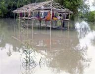
Flood-affected people sit in a damaged hut
as they wait for relief supplies in Lakhimpur
district, in India's northeastern state of Assam.
FILE PHOTO, July 2009. REUTERS/Stringer
According to the ministry of home affairs, almost one million people have been hit by the floods, forcing almost half a million to leave their water-logged villages and seek shelter in government relief camps.
Mountainous Assam, where five people have drowned, has been the worst-affected with 13 out of 27 districts hit by flooding, including Kokrajhar, Lakhimpur, Baksa and Bongaigaon.