Term Path Alias
/regions/meghalaya
/regions/meghalaya

Rivers in North-East India
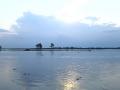
Photo Courtesy: NewsofAP.com
. The apex court also upheld the revised environmental clearances given to Lafarge by the Ministry of Environment and Forest (MoEF) and invoking the principles of sustainable development, inter-generational equity and the doctrine of proportionality the Bench stated “The word “development” is a relative term. One cannot assume that the tribals are not aware of principles of conservation of forest. In the present case, we are satisfied that limestone mining has been going on for centuries in the area and that it is an activity which is intertwined with the culture and the unique land holding and tenure system of the Nongtrai village. On the facts of this case, we are satisfied with the diligence exercise undertaken by MoEF in the matter of forest diversion.”
 Newsletter of South Asia Network on Dams, Rivers and People (SANDRP) for April - May 2011 (Volume 9 Issue 3-4), focuses on the following topics.

Main highlights in this update:
 Organizers:
Venue: North Eastern Space Application Centre (NESAC), Shillong
 This report by Kalpavriksh, Aaranyak and ActionAid India deals with the large dams’ juggernaut, which happens to be the biggest ‘development’ intervention in this ecologically and geologically fragile, seismically active and culturally sensitive region in the coming days. With the Northeast identified as India’s ‘future powerhouse’ and at least 168 large hydroelectric projects set to majorly alter the riverscape, large dams are emerging as a major issue of conflict in the region.
Although the current scale of dam-related developments far outstrips anything which took place in the past, the region has been no stranger to dam-related conflicts. For example, the Kaptai dam, built in the Chittagong Hill Tracts of East Pakistan (now Bangladesh) in the 1960s, submerged the traditional homelands of the Hajong and Chakma indigenous communities, and forced them to migrate into parts of Northeast India.
The report presents flood plain mapping of Phulbari area within the flood plains of Brahmaputra basin in the States of Assam and Meghalaya using satellite data. Flood is a natural calamity in which most parts of the north-eastern region are ravaged. Management of the problem in these disastrous flood affected areas often requires flood plain mapping for protection and resource development. This has mostly being done in real time on the basis of time consuming and often hazardous ground based surveys.
In the study, the hydrogeomorphological parameters of Myntdu basin have been estimated from a digitized basin map where basic map data could be retrieved and manipulated quickly and accurately. The estimated geomorphological parameters of the basin covering linear, areal and relief aspects will be helpful in estimating and modeling the flow process in the basin.
The study attempts to do field and laboratory determination of soil classification properties in the Dudhnai river basin of Assam and Meghalaya. Point infiltration tests using double ring infiltrometer were conducted at various locations (forty-four sites) in respect of different land use conditions. Soil samples were collected from these infiltration testing sites.
The saturated hydraulic conductivity was determined in the field using Guelph Permeameter for the selected sites. The undisturbed soil samples and disturbed soil samples (50 cm below the ground) were collected and subjected to elaborate laboratory tests.