/regions/krishna
Krishna
Flood Assessment Report of Mahabubnagar District - II
Posted on 16 Nov, 2009 10:54 AMNow that the media has stopped taking interest in the devastating floods that made news in early October, you must be wondering what must have happened to the people who were badly affected by the floods !
Assesment report in Mahbubnagar district
Posted on 12 Oct, 2009 11:18 PMAttached is an assesment report of the status in Mahbubnagar district created by a team of civil society representatives. The report makes reference to a networking effort of civil society organisations in order to co-ordinate their efforts, and the team promises to continue to survey the situation and make periodic reports.
Information from ReliefWeb
Posted on 08 Oct, 2009 12:45 AMA map of the affected areas can be seen at this URL
http://www.reliefweb.int/rw/rwb.nsf/(db900SID)/LPAA-7WKB6S/picture/0.84?OpenElement&FieldElemFormat=gif
and is also attached to this blog entry
The below is a brief summary of the events:
OVERALL SITUATION
Heavy rains due to depression in the Bay of Bengal and low pressure from the Arabian Sea from Sep tember 29 to October 2 have caused flash floods in north Karnataka and the Rayalaseema region of Andhra Pradesh, affecting nearly two million people and claiming 210 lives. In Karnataka, 15 districts are affected and 161 people have nearly tw millionperished. In Andhra Pradesh, five districts were hit by the flash flood and 49 people have lost their lives. However, of the two million, 1.4 million people affected are from Andhra Pradesh.
Impact of climate change on river deltas and other coastal areas in India
Posted on 26 Aug, 2009 04:23 PMThe effects are most visible in the Sunderbans. Literally the 'beautiful forest', these wetlands at the mouths of the Ganga and Brahmaputra river systems are among the largest mangrove forests in the world. About 62% of this area of some10000sq km lies in Bangladesh but there is a significant Indian portion in the state of West Bengal.
Map: Location of water resource projects across river basins in India
Posted on 20 Aug, 2009 03:23 PMThe map indicates that across the main 19 river basins of the country, water resource projects with a total live storage of 174 BCM (Billion Cubic Metres) have been completed, 75 BCM are ongoing, and 132 BCM are being planned.
River systems of Karnataka: Overview of the state's river systems and irrigation patterns
Posted on 14 Aug, 2009 03:19 PMThe Water Resources Department of Karnataka has a lot of relevant information on the river systems in Karnataka, irrigation, water resource development projects in Karnataka, notifications and orders, performance budgeting and allocation.
River basins and river basin organisations in South Asia
Posted on 22 Jul, 2009 03:12 PMAs part of the research study, River Basins and River Basin Organisations in South Asia, done by the Society for Participatory Development Hyderabad, CapNet South Asia (Read More) and Gomukh Environmental Trust for Sustainable Development Pune (Click Here), data about individual river basins has been collected for the river basins in South Asia.
Spatial modelling approach to water pollution monitoring in the sugar belt of Maharashtra along the Krishna river
Posted on 20 May, 2009 12:49 PMThis paper on the GIS Development site highlights the findings of a study taken up for the monitoring, identification and suggesting preliminary measures of water pollution cont
Water issues faced in Hyderabad metropolitan city - A presentation by Hyderabad municipal water supply and sewerage board
Posted on 12 May, 2009 12:36 PMThis presentation by M G Gopal of the Hyderabad Metropolitan Water Supply and Sewerage Board deals with the water issues faced in the city. The issues presented include – (a) Inter-sectoral allocation (b) Meeting the demand (c) Maintaining quality standards (d) Reducing unaccounted for water (e) Recycle and reuse (f) Promoting rainwater and conservation (g) Implementation of CDS and (f) Is ‘privatisation’, a solution or a disaster?
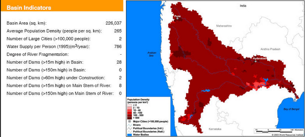
Basin maps of Krishna river showing basin indicators, landcover classes and biodiversity information and indicators
Posted on 17 Apr, 2009 01:25 PM
Basin indicators map of Krishna river basin