/regions/godavari
Godavari
Modeling at Vasishta-Godavari river mouth using FESWMS – A research report by National Institute of Hydrology
Posted on 28 Jun, 2010 10:54 PMThe study attempts to undertake surface modeling to simulate the water levels in the mouth portion of Vasishta-Godavari by taking the tidal effect during a flood season, by using the Finite Element Surface Water Modeling System (FESMWS) developed by United States Geological Survey (USGS) to model the reach. The objective is to simulate the surface water flow for a flood discharge of 2.35 lakh cusecs, under the effect of diurnal tide at the bay end.
The surface water levels of a river, especially at the mouth are required for planning and managing flood alleviation schemes and river engineering works. In the lower reaches of many rivers, flood plain inundation may result from very high tide or a very high flood or a combination of both. Also the extent of landward intrusion of saline water into a river at mouth varies with the relative strength of freshwater discharge and the co-oscillating tidal flow resulting from the dynamical interaction of the adjacent coastal waters.
Contest to mark World Wetlands Day organised by WWF in Vijayawada
Posted on 02 Feb, 2010 03:19 PM

VIJAYAWADA: School children will be with one another to list the number of animals and plants they can recognise in a competition being held by the World Wildlife Fund (WWF) and the Forest Department at Kaikaluru on Tuesday.
Barrages would prevent Polavaram dam from being an economic and environmental disaster : Analysis reveal
Posted on 12 Jan, 2010 02:20 PMProf.T.Shivaji Rao,
Director, Centre for Environmental Studies,
Gitam University, Visakhapatnam.
Historical Developments: Initially the Polavaram project was proposed as a storage reservoir with FRL at +150ft with a water storage of about 150TMC in 1941. Subsequently many changes were made and in 1948 it emerged as Rampada Sagar dam with FRL at +208ft. with water storage of 836 TMC including 150 MW of hydro-power generation at an estimated cost of 129 crores (at 1948 rates) This scheme was abandoned because it was too costly and was bristled with foundation and construction problems. Subsequently several expert committees were appointed by the Government of India to study the problems of Godavari water utilisation. These committees under the Chairmanship of Dr.A.N. Khosla (1953), Mr.Gulhati (1963) and Mr.A.C.Mitra (1965) suggested to the state Government to build a barrage at Polavaram for improving the irrigation facilities and also to divert Godavari flood water into Krishna river. https://www.thehindu.com/2009/05/02/stories/2009050260540600.htm
Impact of climate change on river deltas and other coastal areas in India
Posted on 26 Aug, 2009 04:23 PMThe effects are most visible in the Sunderbans. Literally the 'beautiful forest', these wetlands at the mouths of the Ganga and Brahmaputra river systems are among the largest mangrove forests in the world. About 62% of this area of some10000sq km lies in Bangladesh but there is a significant Indian portion in the state of West Bengal.
Map: Location of water resource projects across river basins in India
Posted on 20 Aug, 2009 03:23 PMThe map indicates that across the main 19 river basins of the country, water resource projects with a total live storage of 174 BCM (Billion Cubic Metres) have been completed, 75 BCM are ongoing, and 132 BCM are being planned.
River systems of Karnataka: Overview of the state's river systems and irrigation patterns
Posted on 14 Aug, 2009 03:19 PMThe Water Resources Department of Karnataka has a lot of relevant information on the river systems in Karnataka, irrigation, water resource development projects in Karnataka, notifications and orders, performance budgeting and allocation.
River basins and river basin organisations in South Asia
Posted on 22 Jul, 2009 03:12 PMAs part of the research study, River Basins and River Basin Organisations in South Asia, done by the Society for Participatory Development Hyderabad, CapNet South Asia (Read More) and Gomukh Environmental Trust for Sustainable Development Pune (Click Here), data about individual river basins has been collected for the river basins in South Asia.
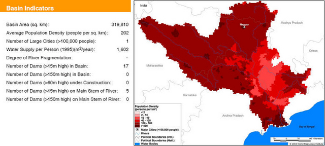
Basin maps of Godavari river showing basin indicators, landcover classes and biodiversity information and indicators
Posted on 17 Apr, 2009 12:42 PM
Basin indicators map of Godavari river basin
Compilation of data for Cauvery basin for river basin planning along with maps of major river basins of India
Posted on 17 Apr, 2009 09:49 AMWater flows without regard to political and administrative boundaries. Water planning with respect to rivers should therefore be done for the river basin (or sub-basin) as a whole. River basin planning also has to look in an integrated way at all the relevant parameters like urban and rural populations, water usage patterns, water pollution, wastewater flows.