Chotanagpur Plateau

Term Path Alias

/regions/chotanagpur-plateau

From suspecting black magic to diagnosing fluorosis: Madhya Pradesh's struggle
Fluorosis was first discovered in Madhya Pradesh in 1997. Since then half the state has been affected. The people involved in combating the spread of this disease in the state share their story. Posted on 02 Oct, 2015 12:08 PM

It was 1995.

The use of borewells in fluoride-affected areas, such as this one in Dhar, is one of the primary reasons for fluorosis. (Source: Chicu Lokgariwar)
Keepers of a complex irrigation system in Bihar
The Ahar Pynes irrigation systems were originally built and managed by the Zamindars of South Bihar. How does the system function today and who is responsible for it? Posted on 02 Mar, 2015 12:28 PM

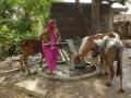
For as long as local records exist, the countryside of  South Bihar has witnessed a lone man striding across the fields night and day. In the past, he was accompanied by a lantern and a lathi. Today, his companions are a bicycle and a mobile phone. He is the Bandhwe, a man charged with overseeing the irrigation channels of the area.

Rameshwar Yadav, Bandhwe of Jamune Dashayan Paine
The pond with a purpose
The residents of Gobariya village built two ponds for livestock rearing and horticulture, but a chance discovery led to them becoming a quicker and better income generator. Posted on 21 Feb, 2015 06:02 PM

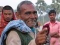
The Bhuiyas, a group of people who belong to the Scheduled Castes in Jharkhand and Bihar, have historically been landless foragers -- a fact reflected in their name which means 'of the earth'.

Celebrating the pond at Gobaria
Tribals in Jharkhand plan for water security
To let people make their own decisions and to understand that the best solution doesn't always work are two big lessons that have come from meetings with Jharkhand's tribals. Posted on 14 Oct, 2014 03:15 PM

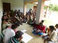
"Clean water", emphasized the woman. "'Close to the house. Whenever it is needed", she added. She was speaking at a village meeting organised to determine what was needed to make the village water secure. The discussions had begun with an attempt to define water security.

A planning meeting in Bhawani Chowki
Development of regional flood frequency relationships using L-moments for South Bihar – A research report by the National Institute of Hydrology
In this study, regional flood frequency relationships have been developed using L-moments for the alluvial plains of Indo-Gangetic basin and Kaimur-Chhotanagpur Santhal Pargana plateau. Posted on 14 Jul, 2010 10:55 PM

In this study, regional flood frequency relationships have been developed using L-moments for South Bihar, in the alluvial plains of Indo-Gangetic basin and Kaimur-Chhotanagpur Santhal Pargana plateau. The annual maximum peak flood data of twenty-two gauging sites whose catchment areas vary from 11.7 to 3171 sqkm have been used. The mean annual peak floods of these sites vary from 29.15 cumec to 1293.2 cumec. Comparative regional flood frequency analysis studies have been carried out using some of the commonly used frequency distributions viz Extreme Value (EV1), General Extreme Value (GEV), Normal, Log Pareto (GPA) and Wakeby based on L-moments approach.

Watershed scale planning- Application of rainwater harvesting techniques
Two examples of a watershed scale application of rainwater harvesting techniques. Posted on 15 Sep, 2009 04:20 PM

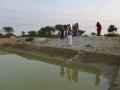
The first project was conducted by the BAIF Development Research Foundation in the Hassan District of Karnataka. They created a linked network of 350 farm ponds covering 700 hectares of the watershed.

Impact of climate change in India: An agro - ecological zone level analysis
A detailed look at the possible impacts of climate change on the different agro - ecological zones demarcated in India Posted on 20 Aug, 2009 06:04 PM

India is gifted with heterogeneous landforms and variety of climatic conditions such as the lofty mountains, the raverine deltas, high altitude forests, peninsular plateaus, variety of geological formations endowed with temperature varying from arctic cold to equatorial hot, and rainfall from extreme aridity with a few cms (<10 cm) to pre humid with world's maxim

Geographic information system (GIS) and groundwater for windows (GWW) helps in creating interactive groundwater information system (GWIS) of Barakar basin in Bihar
The paper discusses the approach adopted for establishing groundwater information system (GWIS) where data from various sources can be stored and analysed in time and space Posted on 20 May, 2009 10:21 AM

This paper on the GIS Development site discusses the approach adopted for establishing ground water information system (GWIS) of the Upper Barakar Basin using geographic informati

Groundwater modeling of unconfined aquifer system of crystalline area - a case study in Lapsiya watershed (Hazaribagh)
The paper concludes that the success of unconfined aquifer system in a hard rock area depend upon the thickness of the aquifer material Posted on 20 May, 2009 10:18 AM

This paper on the GIS Development site discusses the findings of a  modeling exercise that was attempted in Lapasiya watershed, Hazaribagh, India.

Groundwater prospects analysis through hydrogeophysical parameters and hydrogeomorphic zonation - a case study in parts of Kewta watershed - upper Barakar basin - Bihar
The study integrates hydrogeomorphic and hydrogeophysical approach for groundwater exploration for Kewta watershed, upper Barakar basin, Bihar Posted on 19 May, 2009 01:43 PM

 In this paper from the GIS Development site present study, hydrogeomorphic zonation has been carried out through remote sensing technique.

×