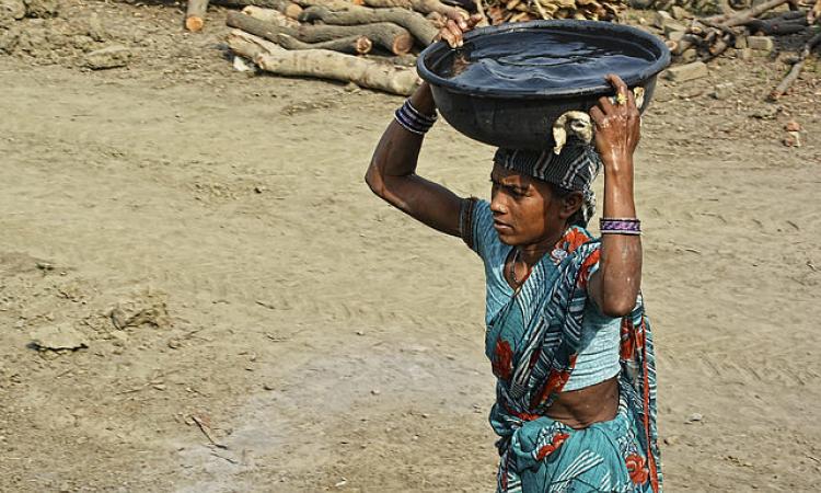
Poverty and water scarcity: The linkages
Water scarcity, exacerbated by climate change, could cost some regions up to 6 percent of their gross domestic product (GDP), trigger migration, and give rise to conflicts. Water scarcity being a multidimensional issue is not only linked to physical availability of resources but also with poverty and it has been realised that there is a link between income poverty and water poverty.
In the Indian context, various studies have explored links between poverty and water scarcity using the Water Poverty Index (WPI), but only a few have analysed it at downscale spatial units argues this paper titled 'Assessing the spatial variation of water poverty determinants in Maharashtra, India' published in Water Policy. This is because water availability can be variable on a spatial and temporal scale and a number of geographical and topographical factors influence water poverty more than income poverty.
Local water infrastructure development also determines water availability and people’s ability to access it calling for the need to design location specific approaches to support water-related livelihoods. For this, water poor areas need to be identified at the local scales. As water is a state subject, measuring water poverty at the district level can help examine how multi-tier governments can address district-level water poverty. However, there is a dearth of studies at the district scale in India.
District level water poverty in Maharashtra
The study constructs district-level water poverty measures (for 33 districts based on available data) and mapping the spatial heterogeneity for Maharashtra in India.
Maharashtra, located in the western part of India occupies a significant portion of the Deccan plateau. Thirty-six state districts are in six revenue divisions: Konkan, Nashik, Pune, Aurangabad, Amravati, and Nagpur. Bounded by the Western Ghats Mountain range, there is a significant climatic divide, and the state has varying climates from tropical wet to semi-arid.
The state receives maximum rainfall during the southwest monsoon (June–September) and intrastate disparities are contrasting. Water supply in the state has improved over the years, but only 50 percent of households have access to tap water. Treated water is available to only 32 percent and less than 42 percent of the rural population gets access to drinking water within their premises. Also access does not guarantee safe and continuous water supply.
Despite substantial rainfall and major rivers flowing through the state, rising population, shrinking surface water bodies due to pollution, declining water quality, and poor water management have accentuated severe water scarcity. In light of the above context, constructing a multidimensional index seems crucial to assess district-level water poverty.
Water Poverty Index
The study considered two sub-components: the physical water availability and seasonal variability (as a measure of reliability). Groundwater (fluctuations from its mean levels) and surface water for 20 years was used as indicators to measure the physical availability of water. The variability of water over space and time was used to measure the reliability of available water resources. Evapotranspiration was another important variable considered for the study.
Water Poverty Index was measured using the following components
- Resources: Variability and quality, the total physical availability of water (surface and ground water)
- Access: Access to the safe water source reflecting the total distance covered and time spent on water collection per household. Also included are access to water for irrigation and industrial purposes
- Capacity: Ability to manage water from improved sources. This represents lobbying capacity for water based on income level, education, health, and infrastructure
- Use: Water consumption by different sectors, i.e., agriculture, industry and domestic
- Environment: Impact of water management on different ecosystems to safeguard ecological integrity
Water quality information was dropped due to lack of data availability at the district scale . Mumbai city and Mumbai suburban were not included due to lack of availability of data for some indicators.
The study found that:
There was a great disparity relating to water poverty across the districts. The overall WPI score for Maharashtra was found to be 0.47, indicating the poor performance of the state across all five components. Out of 33 districts selected, 21 belonged to medium to very high categories indicating the severity of water poverty situation in the state. Eleven districts had very low and low scores, indicating better performance in water poverty across all five components of WPI.
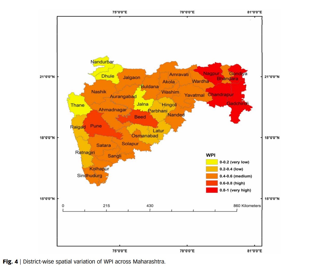
Konkan division: Thane, Ratnagiri, and Raigad performed well in the overall WPI except for Sindhudurg, which displayed medium water poverty. The region has high forest cover, households with improved water services, less use of fertilisers per hectare of land with low variation in the groundwater level, surface water, and rainfall over the years. This has helped the region to maintain better scores in terms of environment, resource, and capacity components. However, there is a need to improve sanitation facilities and better access to irrigation.
Pune division: Had medium to high overall WPI scores indicating medium to high water poverty across the districts. Rainfall varies from very high to low in this region. The Krishna River, along with most of the west-flowing rivers passing through the area are rain dependent. The surface water variation is also very high, leading to variable water availability.
Nashik division: Has tribal-dominated districts with low to medium WPI scores and the region is overall water secure. Major rivers of the state, namely, Godavari and Tapi, flow through this part of the state. But the physical availability of water is similar to the Pune division, with high variation in rainfall and surface water.
Marathwada and Amravati and Nagpur divisions: These fall under the medium to high category of WPI scores indicating the poor water situation of the regions. These are the drought-prone and impoverished regions of the state. Seasonal groundwater deviation is very high and a large population is dependent on cultivation of water-guzzling cash crops such as cotton and sugarcane. The rainfall variation in these regions is excessive, and the dependency on rain-fed rivers to fulfil their water needs escalates the severity of the water situation. Nagpur performs poorly across all five components of WPI, capturing the region’s distressing water problems.
Local-scale policy-making crucial for better water resource management
The study concludes that Maharashtra falls under the unsafe category regarding the WPI and argues that water resource availability is not the only factor in reducing water stress, but appropriate water management is equally necessary. It is important that decision makers focus on the distinct economic, social, and climatic spatial variations across the state and explore ways of managing water based on these variations. Along with the physical abundance and accessibility to water, improvement in the determinants of capacity and environment are essential to tackle water poverty.
The study emphasises the importance of highlighting the intra-district variations among components of water poverty, indicating the importance of local-scale policy-making for better water resource management.
/articles/spatial-variations-water-poverty-determinants-maharashtra