Spending a week on a cramped boat with five strangers may not sound like fun to many but it was a dream come true for me. When I found a note in my inbox that said ”I want to travel down part of the Ganga by boat. Would you know of anyone who is interested”? , I jumped at the chance and set off on an unforgettable journey with five others. We travelled on a little rowboat that was about 20 feet long, cooked our meals in it, and camped at night. Truly unforgettable.
The Ganga's designation is National Waterway 1 (NW-1). A waterway is a river that also functions as a highway - a navigable river, if you will. The Ganga's label then possibly makes it the equivalent of the Grand Trunk Road. One would think that the automatic significance of that would be heavy traffic plying both passengers and cargo continuously but the reality was far from it. Small canoes ferrying villagers across the river and boats laden with sand were our only river-mates. I wondered if it had always been this way. Had the sandy and ever-changing plains that the Ganga flowed through always negated the possibility of heavy traffic? I decided to find out more about this important waterway.
Maintaining our waterways:
The first thing I learnt was about the authority that monitored waterways in India - The Inland Waterways Authority of India (IWAI). It came into existence through an Act of Parliament in 1986 with a mandate to develop and manage designated inland waterways, which are rivers and lakes that can be used for transport. Ocean-travelling ships and the infrastructure required by them are managed by the Ministry of Shipping, but are not under the purview of the Authority.
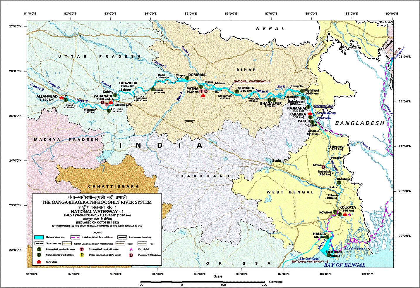
Mr. Surendra Singh of IWAI (Varanasi) equated the Authority’s role in waterways to that of the Public Works Department's in roads. It was responsible for maintaining a particular depth throughout different parts of the river so that boats don't hit the bottom. For NW1, the depth is as follows for these particular areas:
- Allahabad to Ghaziabad - 1.50m
- Ghaziabad to Patna - 2m
- Patna to Haldia- 2.50m
The stretch of the Ganga designated as National Waterway 1 (Source: Inland Waterways Authority of India)
A knee-jerk reaction to maintaining this depth might be to create a neat channel in place of the river by encasing it in concrete. But ‘training’ a river by building concrete walls on its banks isn't always the best option for the river and those who live by it. Blocking off the river banks using man-made structures destroys the partially-submerged edges of the river, which provide a home to many plants and animals. This also affects other animals who eat these creatures. Further, the steep concrete banks also do not allow animals to drink water from the river and may drown them. To its credit, the Authority understands this and doesn't do anything to upset the eco-system. Instead it surveys the river bed, determines the deepest part of the channel over which boats can safely travel and maps this information. These maps are available with them and are crucial for pilots of large boats plying on the river. The Authority also ensures that this deep channel is maintained at the minimum depth mentioned before by regular dredging, which is to move out underwater sediments and soils.
Thanks to these maps, traffic on the waterway is steadily increasing. In 2009-10, NW1 saw 3308 tons carried against 672 tons in 2008-09. That’s almost a five-fold increase. Most of this was in the lower part of the river from Bengal to Bihar. This does not account for the informal cargo transport (largely sand and timber), which makes up the bulk of the traffic on the river, especially in the upper parts bordering areas such as Uttar Pradesh around Allahabad, Varanasi and Garhmukteshwar.
Who are these 'informal' operators?
The bulk of the traffic on the Ganga is not made up of large ships carying industrial cargo such as ores and machinery, but of smaller boats belonging to people who have been using the river for many generations. In the 18th century, most boats carried salt and sand with a few others carrying cotton and other goods. 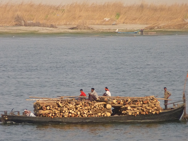
Today, sand and timber make up the bulk of the cargo being transported. Excavation of sand from the river banks for sale to the construction industry is common along the Allahabad-Varanasi stretch. While this is largely mechanised with JCBs doing the heavy digging, the design of the boats used for this purpose has not changed over centuries.
Most villagers who live by the banks of the river also own small boats. These boats are built by crafts persons like Anil, whose family has been building boats in Varanasi for three generations. He explained the process to me while I watched him work.
The photo below shows a 24 foot boat that carries tourists along the ghats. These boats are used for day-to-day tasks like fetching fodder or commuting to the weekly market.
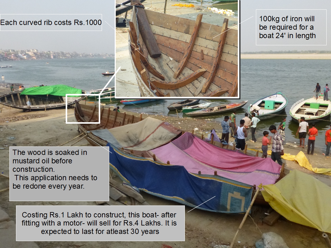
The mechanics and finances of boat building (Photo: Chicu)
Transporting cargo by boat – the advantages
If properly managed, transporting by water is not only cheap but also energy-efficient. This could reduce the load on our national highways as well as the resultant pollution.
Transporting cargo by boat – the disadvantages
While transport by water is cheap, factories and markets are not always situated at ports. This means that cargo needs to be loaded and unloaded much more than while transporting by road or rail. This increases the cost, causes more delays, and even ups the risk of damage.
How will transportation affect the river?
If the river is to be used for transporting cargo, it will need a reliable and predictable depth. In shallow rivers, ships are in danger of running aground, or getting stuck in the mud. This can't happen. The need for reliable depth will prove to be a strong economic argument for increased freshwater flows. But it is dangerous to consider the river as nothing more than a conveyor belt. Rivers have an ebb and flow with occasional floods while boats need a steady, predictable flow. This potential conflict can be detrimental for the river as has happened in the United Stateswith the Columbia. The demand for increasing the 'navigability' of the Columbia transformed a vibrant river full of aquatic fauna into a series of locks and placid stretches. This not only wiped out the salmon population, but also many of the tribes and other communities that had settled by its banks. (For more information, refer to 'A river lost' by Blaine Harden, a superb eulogy and and an urgent lesson)
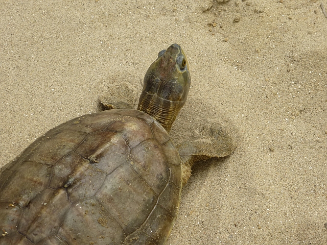 Leaks from ships frequently harm aquatic life. The stretch of the Ganga designated as NW1 has two wildlife sanctuaries, the Ramgarh turtle sanctuary (a 7 km stretch) near Varanasi in Uttar Pradesh and the Vikramshila Dolphin sanctuary (a 50-km stretch between Sultangaj and Kahalgaon) in Bhagalpur district, Bihar. The rules forbid mechanised boats within the sanctuary limits but the Authority does not acknowledge these rules or even the existence of these wildlife areas.
What happens next?
That is a loaded question because both the Ministry of Road Transport & Highways and the Ministry of Shipping (which oversees the Authority), can feign ignorance on each other’s doings or non-doings! Throw in the Ministry of Environment and Forests and the problem becomes even bigger. All this will lead to is a river that is a lot like the rope in a game of tug-of-war; no matter which team wins, the rope loses.
A better option would be to take a negotiated approach, which recognises that everyone stands to gain from a healthy river that has adequate flows that ebbs and flows with the seasons. A river that supports boats and wildlife, farmers and fisher folk. There are many terms for this – an integrated approach, a negotiated approach, a value- based dialogue etc. but what it boils down to is people listening to each other's point of view. This may be a difficult task, but the prize is well worth it.
/articles/navigating-national-waterway-1-or-ganga-we-call-it
