As high as 600 million Indians suffer from high to very high water stress because of insufficient availability of freshwater. Population growth, changing cropping patterns, industrialisation, and urbanisation are not only affecting surface freshwater resources, but also leading to higher rates of withdrawal of groundwater than recharge informs this paper titled 'Mapping of groundwater potential zones in a drought prone Marathwada Region using frequency ratio and statistical index methods, India' in Results in Engineering.
Groundwater, a valuable resource for India
Groundwater is stored in aquifers, bodies of rocks or rock matter, which are capable of storing significant quantities of water and transmitting it to wells. Groundwater supplies can be replenished or recharged through rain and snow melt that seeps down into the cracks and crevices beneath the land’s surface. In some areas of the world, people face serious water shortages because groundwater is used faster than it is naturally replenished. In other areas groundwater is polluted by human activities. Occurrence of groundwater depends on the geomorphological and hydrogeological settings of the region.
Read our FAQs on groundwater to know more
In India, about 90 percent of the rural and 50 percent of the urban population depends on groundwater for domestic purposes. Sixty two percent of groundwater is used for irrigation and 85 percent for rural and 45 percent for urban water supply. Water resources in arid and semi-arid regions of India are more vulnerable because of inadequate rainfall, high temperatures, and evaporation. As high as 60 percent of India’s productive land (94 million ha) depends on the rain, and more than 50 percent of the area experiences droughts every four years.
Marathwada in Maharashtra
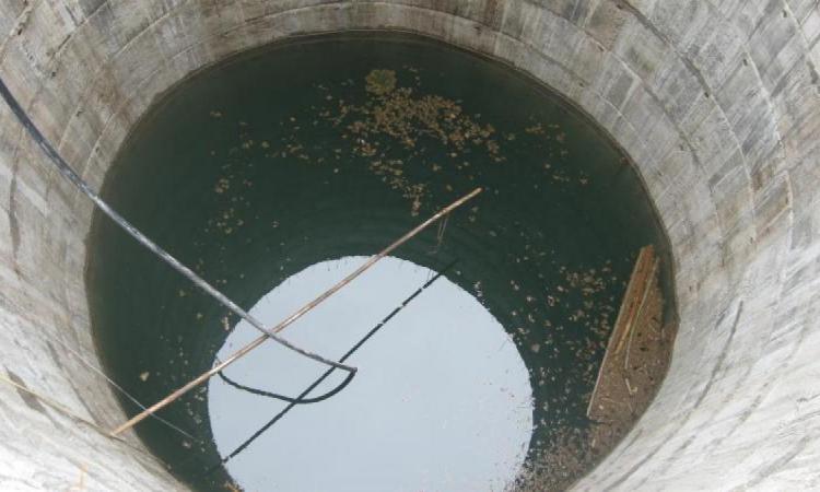
Marathwada region of Maharashtra frequently experiences droughts due to poor rainfall and groundwater is considered an alternative source of water supply for domestic use and irrigation in the region and continues to be overexploited through drilling of deep borewells.
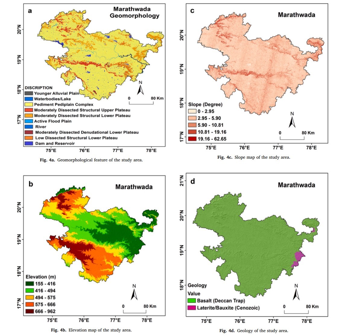
It consists of eight districts specifically, Aurangabad, Jalna, Parbhani, Hingoli, Nanded, Beed, Latur, and Osmanabad. The region is a mostly covered with deep black cotton soil and the main crops in the region include Kharif crops like soybean, cotton, bajra, pulses and maize and Rabi crops like wheat, jowar, and maize.
Groundwater potential zones for groundwater management
Having an idea of the groundwater potential zones (GWPZ) is essential for groundwater management and the construction of recharge structures to manage and improve groundwater resources. The study aims at identifying GWPZ at regional scale in Marathwada using probabilistic models of Frequency Ratio (FR) and Statistical Index (SI) in GIS software and delineate GWPZ in the hard-rock and semi-arid areas of the region.
The study explores the following factors influencing groundwater potential:
- Geomorphology: Affect the rate of percolation and recharging of surface water into the subsurface layers of the earth
- The elevation: Groundwater recharge is inversely correlated to the altitude. Thus, wells located in the lower elevation areas have maximum groundwater potential than that of the wells located in the higher elevation
- Slope: Determines rate of infiltration of rainfall and runoff. A region with higher slope generates more runoff and less infiltration, while lower slope region has more infiltration rate and less runoff, which increase probability of occurrence of groundwater
- Rock types: Rock types and fractures and joints present in the rocks determine groundwater movement and accumulation. Porosity and permeability of rocks control the existence and movement of groundwater in the region. About 86 percent of the area of Marathwada consists of Basalt rock (Deccan Trap), and 14 percent of area is composed of Laterite/Bauxite (Cenozoic) rocks.
- Rainfall: The mean monsoon rainfall of the Marathwada is 636 mm and the annual average rainfall of the region is diverse from 541 mm to 1063 mm and it is one of the major sources of groundwater replenishment in the region.
- Stream density: High stream density in the region causes lower rate of infiltration and higher rate of surface runoff.
- Soil types: Hydraulic characteristics of the soils have significant influence on surface runoff and infiltration rates of water. The soil texture and particle size affect the groundwater infiltration capacity and the vertical and lateral water movement.
- Landuse/landcover (LULC): affects the runoff, evapotranspiration, soil moisture, surface water infiltration, permeability processes and groundwater levels. In Marathwada region, agriculture land areas have high potential for groundwater recharge as compared to other land use areas
Mapping groundwater potential zones
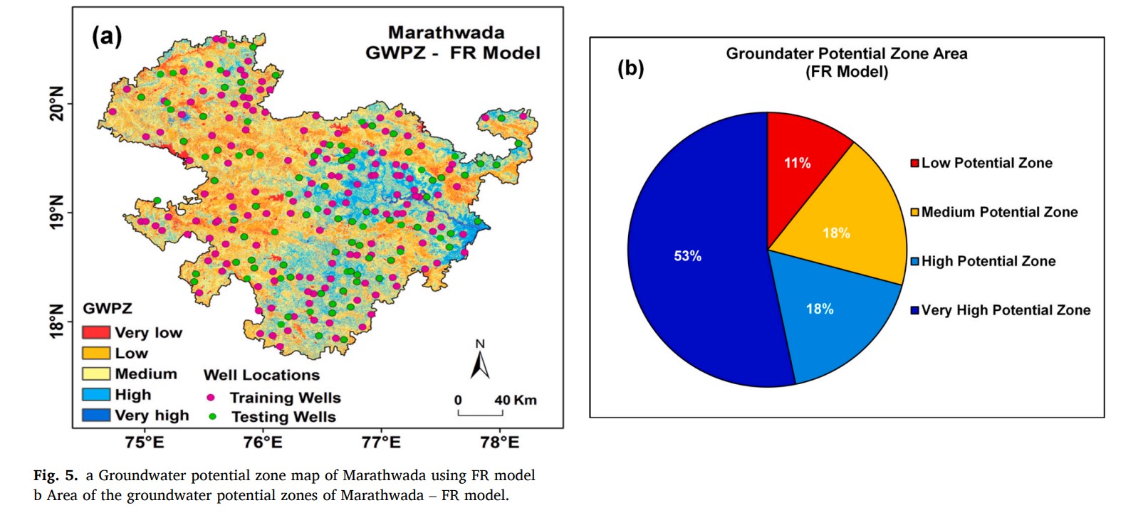
According to the FR model, 53 percent (34,233 Km2 ), 18 percent (11,626 Km2 ), 18 percent (11,626 Km2 ) and 11 percent (7105 Km2 ) of the area in the Marathwada can be categorised as having very high, high, moderate and low potentiality of groundwater respectively.
Conversely, the SI model indicates that 65 percent (41,984 Km2 ), 27 percent (17,439 Km2 ), and 8 percent (5167 Km2 ) of the total area of the region falls in the category of very high, high, and moderate potential of the groundwater respectively.
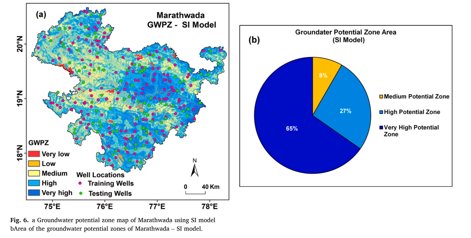
The very high potential zone indicates the maximum possibility for availability of groundwater, while a low zone shows minimum probability of groundwater occurrence. The most substantial GWPZ is observed in central eastern part of the region with low elevation and slope, pediment (gently sloping expanse of rocks) pediplain (flat rock) complex areas with high rainfall covered with Chromic Vertisols (Vc) soil (clay-rich soils that shrink and swell with changes in moisture).
The analysis shows that the SI model is more reliable than FR model to delineate GWPZ in the Marathwada region. The findings can be greatly useful to policy makers for the groundwater management and planning and for farmers to understand fluctuations in the groundwater levels under the influence of changing rainfall patterns, states the paper. It recommends the need to explore fluctuations in groundwater levels by seasons as the next step in gaining an understanding of the behaviour in groundwater levels in Marathwada to identify recharge areas.
/articles/mapping-groundwater-drought-prone-marathwada