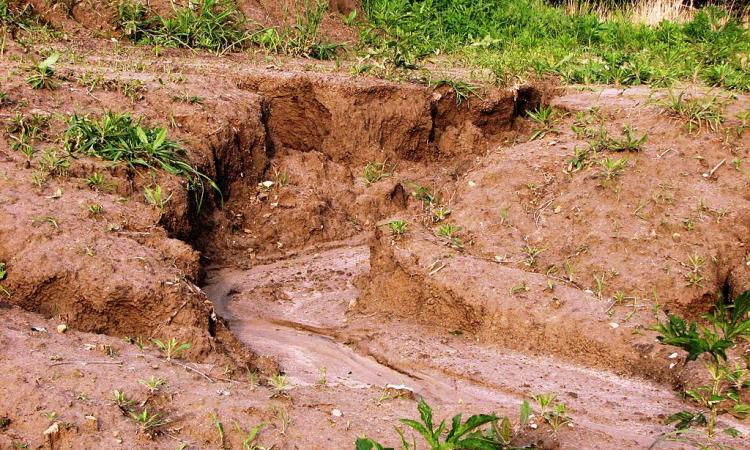
Gully erosion, the most destructive form of soil erosion
Gully erosion is a common form of soil erosion which is caused by flowing of concentrated amounts of surface and /or subsurface runoff which erodes the soil and forms open, unstable channels that have been cut more than 30 centimetres deep into the ground and causes severe land degradation worldwide.
Soil erosion is the process of detachment and transportation of soil particles from the soil mass due to natural factors such as strong winds, heavy rains, flowing rivers, glaciers as well as human activities like deforestation, over grazing, shifting cultivation, over-ploughing of land and other faulty agricultural practices and removal of top soil for industrial or infrastructural purposes.
Read more about soil erosion here
Gully erosion stands out from other types of soil erosion informs this study titled 'India needs a better gully erosion map' published in Current Science. It is deeply erosive as compared to splash (or interrill) erosion, which affects the first few millimetres, and rill erosion, which can erode about half a metre of the topsoil at the maximum. It is much more common than surface erosion and leads to reduced crop yields, deterioration of inland water quality and ecology, and can also pose a threat to human lives and livelihoods.
Precise information of the extent of gully erosion is absent in India
The badlands alongside rivers Yamuna, Chambal, Sabarmati, Mahi, Tapi, Narmada and their tributaries in Central and Western India demonstrate high rates of gully erosion. However, precise information on the real extent of gully erosion continues to be absent in India, inspite of some early attempts.
The Planning Commission published the first figures on the areal extent of gully erosion in India in 1961, which was identified at 41,900 km2 following the National Commission of Agriculture which reported this value at 36,700 km2 in 1976. However, these figures were based on broad observations, rather than mapping or field surveys and were not useful while others that included small-scale maps and broad zonations were insufficient to understand the real extent of the problem.
Presently, India has multiple datasets including an areal map of gully erosion that are included in the land degradation, wasteland and geomorphological atlases. However, all these quote dissimilar figures of the total land area affected by gully erosion in India. The geomorphological map quotes this figure as 24,613 km2, The Land Degradation Atlas at 25,406 km2 and the Wasteland Atlas at 9,953 km2.
The wastelands map has the highest false positive rate followed by that of the geomorphological map, while the land degradation map has a lower false positive rate of 73 percent. The categorical accuracies of the geomorphology map are largely similar, but the two classes of Shallow Ravines and Deep Ravines from the land degradation dataset have appreciably lesser false positive rates than the Gullies class.
Thus, of the 700 features assessed, only 21 percent seem to be mapped accurately. One of the important reasons for this is the poor resolution relative to the dimensions of the features such as gullies. This is because all three atlases were prepared through visual assessment and the chances of misinterpretation were high leading to geomorphic features such as gorges/canyons, first-order (ephemeral) channels and even joints or fractures being mistakenly mapped as gully erosion.
In addition, many areas undergoing gully erosion have not been detected by these atlases while many areas demarcating badlands extend far beyond their current extents due to progressive reclamation, which is not reflected in the existing maps thus overestimating the affected area manifold.
It is important that India deals with gully erosion to achieve land degradation neutrality by 2030. It is thus important to have precise data on the spatial extents of gullies and badlands in the country. Creation of a high resolution map using Google Earth imagery and/or recently released open-source IRS-LISS IV 5.8 m multispectral data is crucial.
/articles/improved-gully-erosion-map-needed-india