Come monsoons and reports of landslide events start appearing from different parts of India including Maharashtra. Indeed, an exponential rise in the occurrence of landslides and mudslides in Western Maharashtra is being reported in recent years. And these can unleash massive destruction, lead to loss of lives and damage infrastructure and property.
The need to develop a vulnerability framework, and an early warning system to deal with potential incidents of landslides in Western Maharashtra is thus crucial argues this rapid field assessment followed by action planning titled ‘Landslides of Western Maharashtra: Rapid appraisal for developing improved preparedness and early warning systems for landslides in Western Maharashtra and Konkan Regions, Maharashtra State’.
A rapid appraisal of landslides was conducted in six talukas from Pune, Satara and Raigad districts of Western Maharashtra and Konkan to identify the triggers for landslides and the reasons for their occurrence. Eighty-four landslides were inventoried and surveyed in detail from Bhor and Velhe talukas in Pune district; Mahabaleshwar and Patan talukas in Satara district; Mahad and Poladpur talukas in Raigad district and Chiplun area of Ratnagiri district over three months.
The assessment aimed at understanding landslides in the context of kind of slope failures, causative factors, triggers for failure and the movement of material following the failure. Factors affecting landslides such as rainfall, slopes, drainage, geology, hydrogeology, ecology and engineering along with social aspects were also explored.
What did the assessment reveal
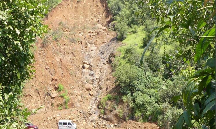
High debris volume increased the threats posed due to landslides
The depth of the excavation at the landslide scar (bare surface of the slope left by removal of earth material from where a landslide started) was found to be variable. The average lengths of the landslide scarps ( a steep surface on the undisturbed ground at the upper edge of a landslide, caused by the movement of the displaced material away from the undisturbed surface) across the 84 landslides was 57.4 m and ranged from 2 m to 600 m. The width of the scarp varied between 2 m and 200 m with an average of 30.3 m.
The length and width of scarps was not always proportionate to each other, but the volume of debris dislodged from the landslide sites was three times larger as compared to the scarp volumes, which led to significant damage.
The thick soil cover and high levels of weathering along the slopes made the area more vulnerable to landslides and led to displacement of large amounts of debris over long distances. This posed as a threat to life and property among the habitations that occupied lower levels of the slopes or those that came in the way of the landslides.
Geological factors determined the vulnerability of the area to landslides
The area falls under the Deccan Volcanic Province (DVP) and two types of bedrock basalts, namely Compact Basalts (CB) and Vesicular Amygdaloidal Basalts (VAB) alternate with each other with variable thickness in the region. These two kinds of rocks respond differently to natural forces that induce weathering or erosion such as wind, water flow, heating due to variations in their porosity and other physical properties.
For example, VABs degrade more easily and have thick zones of weathering as well as soil cover, while CBs do not have soil cover. VABs are relatively impervious and homogeneous, while CBs are the main rocks that have aquifers that store water in the Deccan Volcanic Province. These basaltic flows and flow units are transacted by regional fracture zones that extend across tens of kilometers and dissected by cooling and exfoliation joints, both of which increase the porosity and permeability of the bedrocks.
The assessment found that more than 60 percent of the landslides occurred at the contact between VAB and CB and the failure of the overlying CB in most of these cases was caused due to the removal or instability of the underlying VAB, which got saturated following heavy rainfall thus triggering the event.
Slope failures in 20 percent cases occurred where the bedrock was marked by fracture zones, which made it highly porous and permeable and prone to saturation in cases of heavy rainfall events increasing the pore pressure and subsequent destabilisation of the slope. Twenty percent of the landslides had their scarps occurring along such regional fracture zones transecting the bedrock basalt.
The slope angles played a major role in travel and distribution of the debris material generated from the landslide. Lower angle slopes transported over a shorter distance but had a wider area over which the debris was spread. Higher angle slopes showed longer transport and the debris showed a relatively narrow spread.
Heavy rainfall events were main triggers for landslides
The main triggering point for the landslides was heavy to extremely heavy rainfall when the incoming water into the subsurface was much more than the amount of water that moved out in the in the form of sub-surface drainage, and this led to buildup of large volumes of saturated pore-space in the bedrock, leading to increase in pore-pressure near the slopes, creating instability and triggering landslides.
Water thus had a very important role to play in the form of precipitation, runoff, soil-water and groundwater in landslide occurrences in the region. Water acted in three different phases, first being the massive influx of water, then the build-up of pore-pressure because of continued soil saturation of normally well-drained soils, the rise in the shallow groundwater level in the regolith aquifer (especially in the VABs at the contact zone with the upper CB) and the subsequent transport of the slide due to large volumes of overland flow and surface runoff.
Natural springs were common indicators of a landslide
A number of natural springs were present in the vicinity of many landslides, and there was an increase in the discharge of these existing springs and the emergence of new temporary springs near the landslide just before the landslide event happened.
All landslides were formed by the development of a sustained seepage face at the location of the actual failure zone on account of the water table in the shallow regolith aquifer at the contact of the CB and VAB and the sustained saturation of the overlying soil.
Old growth parts of the forest were found to trigger slope failures
A large percentage of the landslides were found to be on slopes that were forested and especially dominated by old growth trees, although there were other types of land cover that characterised some of the landslides. While the forest cover itself normally acts as a buffer against high runoff, the combination of different water flows, wind and the tall, old-growth part of the forest were found to trigger slope failures.
Landslides damaged public infrastructure in the region
Damage to public infrastructure such as roads, pipelines for draining water, culverts was recorded at many of the locations where landslides occurred, indicating the need for using improved engineering and additional fail-safe mechanisms in landslide susceptible zones.
Preventing landslides
The report argues for the need to make long-term efforts to identify susceptible and vulnerable areas in the larger regions of Western Maharashtra based on the approach followed in the study and for the need to establish an early warning system based on five parameters namely
• Slope movement / soil creep
• Rainfall
• Spring discharge
• Soil piezometric levels (water levels during soil saturation)
• Shallow groundwater levels
These can be used to establish a measurement protocol as the first step in developing the early warning system on landslides in the landslide prone region of Western Maharashtra and the Konkan, while long-term efforts need to involve integrating measurement and mapping-based experiences from the short and interim efforts into a long term plan that can help in establishing robust mechanisms for preparedness and response to landslide events in the region, argues the report.
The authors would like to acknowledge the District Collectors and DDMOs of Satara, Ratnagiri, Pune and Raigad and GSI Pune for their contribution and help in this study.
A copy of the report can be accessed by writing to the authors at Advanced Centre For Water Resources Development and Management here at acwadam@gmail.com.
/articles/how-be-prepared-landslides